 The current tornado watch just missed me, but the action is headed this way and the moisture and shear are already here, additionally, we have had an afternoon of partly cloudy skies, with magnificent cumulus patches coming as an army of clouds, but allowing sufficient breaks in the clouds to allow for daytime heating to destabilize things. The environment is ripe, and it's headed this way.
 3 tornadoes with some scary information about people trapped in homes was reported in Alabama this morning, while I was in CPR training as a continuation of my CERT training.
I don't know what my plans are today.
~Dewdrop
Saturday, February 28, 2009
Tornado watch creeping this way...
Friday, February 27, 2009


John is headed south on highway 82 to intercept a twice tornado warned cell
He's the red dot... winds 30/40mph out of the wnw...
 He is going to head southeast out of Tuscaloosa on 82.
4:35EST:

John Brown is live and headed for tornado warned cell in Tuscaloosa
On the phone with John Brown, who is heading out of Birmingham toward Tuscaloosa, where that cell is getting a pronounced comma look in the reflectivity image...

 Be safe, John!
4:05EST update:
 Alabama Mike is headed out soon.
~Dew
Macon, MS strong supercell!
Ripe cell coming out of Macon, MS. John Brown (Mike's new friend) is going to try to get into position to chase it, as soon as he gets the fax machine working...
Hail in Selma, AL
Janet just shared this shot of the hail in Selma, which was from that cell that Alabama Mike was out in last Wednesday, February 18, 2009. Wow. Thanks, Janet! She says, "This is the hail about 10 minutes after the rain stopped. It hadn't melted much at all because there was so much of it, the ground was cold.
I would guess the hail was between quarter and silver dollar size here, although some reports in the area were of golf ball and tennis ball size hail." Thanks again, Janet!
~Dew
Near miss for Prattville, AL?
 The break that Prattville, Alabama deserves... looks like one going north and one going south of that already once ravages city. Last February, in fact... I really hope that northern one misses them... it looks to be trending south more than the storm track indicates.
2:45EST I hate it when I'm right like that. Tornado warning, headed for Prattville and onto Montgomery.
~Dew
Tornado near Selma and Marion, Alabama
 Again! This is where Mike got caught up in that Hail storm. Looks like a powerful storm, possibly dropping a tornado near Selma and Marion, AL... again. They had accumulating HUGE HAIL last week.
A tornado watch is pending release...
~Dew
Severe weather outbreak today and tomorrow, then snow
Currently, severe weather is making its presence known across portions of the south, with some hail (up to 1 1/4") and wind (trees down) reports already posted on the Storm Prediction Center website.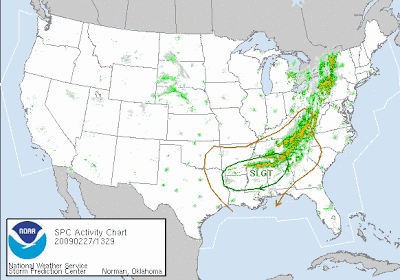 Several cells up in Alabama Mike's neck of the woods are severe warned, and I caught a glimpse of some tornado warned cells feeding in from Mississippi. This is a continuation of yesterday's event, where the plains states reported 60 instances of severe hail (up to 1 3/4") and wind (gusts to 70mph). Here's the thing though, with the moisture and the extremely cold temps, they are talking about snow and some possible accumulation as far south as Atlanta on Sunday. Of course, when you go from 70° weather to accumulations of snow, you've got to have something powerful in between.
  So, severe weather... or as Meso Mike has stated:
 "The ingredients for “severe soup” looks like it made its way into the pot ;-)"
The wording int he outlook isn't powerful, based on some possible inhibiting factors...DURING THE DAY...WARM SECTOR DESTABILIZATION AND A STEADY INFLUX OF BOUNDARY LAYER MOISTURE SHOULD SUPPORT A CONTINUED SEVERE RISK AND A DIURNAL REINVIGORATION OF TSTMS ACROSS SOUTHERN/EASTERN AL INTO GA/FL PANHANDLE. ALTHOUGH STRONG WIND FIELDS/AMPLE SRH WILL CONDITIONALLY SUPPORT A TORNADO RISK. AHEAD OF THE ADVANCING SURFACE LOW/COLD FRONT...STRONG DEEP LAYER WIND FIELDS/AMPLE DIURNAL VEERING WILL SUPPORT POTENTIAL FOR BOTH QUASI-DISCRETE SUPERCELLS /MAINLY DIURNALLY/ AND BOWS WITH MULTI-FACETED SEVERE RISKS OF DAMAGING WINDS/A FEW TORNADOES AND PERHAPS SOME SEVERE HAIL. IF NOT BEFORE...A SQUALL LINE/LINEAR MODE SHOULD BE DOMINANT BY SATURDAY NIGHT ACROSS NORTHERN FL/SOUTHERN GA AS MID LEVEL WINDS BACK/BECOME MORE UNIDIRECTIONAL AHEAD OF THE APPROACHING UPPER LOW.
I'm sure you know that I am not a big fan of the night time squalls... looks like my forecast is leaning that way. Quoting an email from meteorologist, Jeff Rucker in Augusta... An unseasonably strong mid-level trough will drop as far south as northern Florida early Sunday. This brings a severe threat Saturday afternoon and a possibility of flurries or light snow late Sunday night.
So, today, tonight, tomorrow, and tomorrow night, Georgia could see some more action... and then, snow.
Here is our timeline:
Showers move in from west late this afternoon and evening
Heavy rain overnight and in the morning. Rain totals 1 to 2 inches. Heavier rain over north GA and upstate SC.
Chance for severe especially south and east of Augusta Saturday noon to 8pm.
Colder with showers/drizzle Saturday night through most of Sunday
Flurries or light snow showers possible late Sunday night and early Monday.
As with any unusual weather system, the exact track of low pressure will determine where we get the heaviest rain and the highest threat of severe weather.
Weird, weird weather.
11:10EST tornado report... CHELSEA SHELBY COUNTY AL
1:45PMEST:
TREES AND POWER LINES DOWN IN CHELSEA NEAR POST OFFICE ON US HWY 280. CONFIRMED TORNADO.CONCERNING...SEVERE THUNDERSTORM WATCH 37...
~Dewdrop
THE SEVERE WEATHER THREAT FOR SEVERE THUNDERSTORM WATCH 37 CONTINUES.
TRENDS ARE BEING MONITORED FOR THE POSSIBILITY OF INCREASING TORNADIC POTENTIAL...A NEW TORNADO WATCH WILL LIKELY BE ISSUED SOON.
Tornado history, and trying to escape the risk
I had a comment from Kathy in Oklahoma, who said that she would like to live somewhere where there are no tornadoes. I sort of laughed at that since I know that there is not one state in the United States that hasn't had a tornado. In fact, this morning, I learned that on February 11 this year, there was a destructive tornado in Hawaii.  It got me to thinking I should do a post about tornadoes... (like I haven't been doing that already, right?) The graphic above is linked to the Tornado Project website, which is a site dedicated to compiling historic data about tornadoes in the US and Worldwide.
Tornadoes have occurred in every state.~
Actually tornadoes have also occurred on every continent, except Antarctica; however, the United States has the highest tornado incidence of any country, quadrupling Europe's total.~ Yesterday, I posted the fujita scale. The rating determination is based on the level of damage with regard to the quality of structure. As far as the data goes, if a tornado occurs, and no one sees it, and it didn't cause any damage, it does not get recorded (if a tornado happens on open ground, and no one's around to see it, did it really happen???) The doppler, as it is, does not give an image to the ground, which is why storm chasers and spotters are instrumental in letting the National Weather Service know what is actually occurring on the ground.  In the Enhanced Fujita scale, the rating system for tornadoes, the highest and most powerful rating is an EF5. Prior to that, it was an F5, enhanced by the quality of structure analysis built into the rating system. Since 1950, there have been 52 F5/EF5 tornadoes, including the Parkersburg, IA tornado last year, which devastated over half the city. An EF5 is described as causing total destruction. It is a catastrophic tornado.
The deadliest tornado was the Tri-State tornado on March 18, 1925, which took the lives of 695 people. Fortunately, warning systems and weather forecasting technology have improved greatly, and many lives have been spared. In Parkersburg, IA, only 7 perished, which is amazing.
One very interesting tornado story to me in one (well two) that struck in Gainesville, GA, on April 6, 1936, earning the 5th position on the deadliest tornado list, stealing the lives of 203 (with 40 still unaccounted for...) A massive pair of tornadoes moved east-northeast through downtown Gainesville, Georgia, at the start of the work day... after a smaller tornado hit north of town. The course of one of the funnels led into the city from the southwest, just west of the Atlanta highway. The other came in from the west along the Dawsonville highway. These two paths came together west of Grove Street, and a four-block-wide area was laid waste across the entire city, beyond which separate courses of destruction appeared again. The wreckage was astounding, with debris filling the streets up to 10 feet deep. About 750 houses were destroyed and 254 were badly damaged. Damage totalled $12,500,000. The largest death toll in a single building for any US tornado occurred at the Cooper Pants Factory. The multi-story building, crowded with young workers, collapsed and caught fire, killing about 70 people. At the Pacolet Mill, the funnel was seen in the southwest, and the 550 workers ran to the northeast corner of the building, thus averting an even greater tragedy. The wreckage was so deep and swept by fires that it was not possible to determine how many people were killed in which buildings. At the time that the 203 person death toll was listed, 40 persons were still missing. ~source
The tornadoes actually collided in an explosion of catastrophe and then continued in opposite directions, continuing to wreak havoc... The largest outbreak occurred on April 3-4, 1974 (Yikes, the first week in April... I think I know what Mike was talking about when he said that April 4 is a bad storm day!). The SUPER TORNADO OUTBREAK of 1974 was the largest outbreak of tornadoes in a single severe weather event. A total of 148 tornadoes touched in 13 states, including one in Canada.
  As many as 16 tornadoes were on the ground at once during this phenomenal deadly outbreak, which stole the lives of 330 and injured 5,484 people. Six of those tornadoes were rated with an F5 intensity, and twenty-four of them were F4 tornadoes. 48 of those tornadoes were deadly. Amazing.
Back to my point though, Kathy is going to be hard pressed to find a place to live where there are no tornadoes. Granted, she is not doing too well with that objective living in Oklahoma, which is conveniently located in tornado alley. I will cover current weather in a separate post. We are expecting some absolute CRAZINESS!
Have a blessed day.
~Dewdrop
Thursday, February 26, 2009
Tornado powerful enough to rip the bark off a tree
 SKY WATCH FRIDAY time! Please visit Klaus, Sandy, Ivar, Wren, Louise and Fishing Guy, the team for SKY WATCH FRIDAY (click the word to link and participate!) Thanks to Dot and Tom, who were instrumental in the success of this blogging event. You should definitely come fly with us!
Over the past week, I have been discussing the impact of the tornadoes that hit south Georgia on February 19th. Grady and Thomas counties saw a significant amount of damage, first with the long tracked tornado (16.5 mile path) that reached EF2 strength near Thomasville. That tornado lifted, and a second more powerful EF3 tornado dropped no more than 25 miles away from my home.  This picture is of the tree on Salem Road in Boston, Georgia that caused the National Weather Service to elevate the rating of this tornado to an EF3, estimating winds at 140-145 mph.
  You see, the winds in this tornado were so fast and powerful that they were able to rip the bark off of this tree. This same 300-400 yard tornado barely missed a home and caused significant damage to their out-buildings.
It was when my weather radio went off alerting me that something was coming that I checked the radar and saw the monstrous supercell tracking my way. That was when we took shelter in the "safe spot" in our hallway, sitting behind a mattress. This powerful and tornadic supercell tracked for over 4 hours from Alabama, into the Florida panhandle, and into Georgia, where it finally interacted with the moisture boundary and exploded into a powerfully destructive tornado.
Link to Thomasville tornado damage report
Link to Boston tornado damage report
Link to slide show of damage
Link to Examiner articles This was a frightening night for us, but not nearly as frightening as it was for those who actually were directly impacted by the tornado.
All that being said, the Storm Prediction Center has severe weather forecasted for the next 3 days, with Saturday being my big weather day, as well as most of Georgia. It starts in the central plains states today and works its way eastward in the coming days, placing me smack dab in the middle of an area of slight risk for severe weather on Saturday. Given the uncertainties in timing of Saturday's main event, the forecast is very powerfully worded.
 MODELS ARE BEGINNING TO FAVOR POTENTIAL FOR AN OUTBREAK OF SEVERE THUNDERSTORMS...INCLUDING TORNADOES... SATURDAY INTO SATURDAY NIGHT OVER A LARGE PORTION OF THE SOUTHEAST...AND HAVE BEEFED UP (official weather terminology... lol) PROBABILITIES ACCORDINGLY.
A daytime outbreak in my neck of the woods, and I have CPR training and rain-checked Valentine's Day. Plus, my wonderful gtb severely sprained his ankle at work yesterday (I don't even want to get into our 5 hour ER visit...) How do you storm chase on crutches???!
EXPECT ONGOING STRONG/SEVERE ACTIVITY AT BEGINNING OF THE PERIOD. ACTIVITY WILL ALSO LIKELY INTENSIFY NEAR AND AHEAD OF THE FRONT INTO SRN GA/NRN FL AS BOUNDARY LAYER DESTABILIZES BY THE EARLY TO MID AFTERNOON. THREAT SHOULD MANIFEST ITSELF AS BOTH FAST MOVING BOW SEGMENTS AND ISOLATED TORNADIC SUPERCELLS.
The northern half of Georgia needs to keep an eye on Friday night, as the greatest threat there exists during the overnight hours... GA FRI NIGHT/EARLY SAT: CYCLOGENESIS OCCURS OVER NRN LA. SUPPORT OVERNIGHT STRENGTHENING OF STORMS...AND POSSIBLE DEVELOPMENT OF ONE OR TWO CONVECTIVE CLUSTERS. THESE SYSTEMS SHOULD MOVE GENERALLY E...WITH EMBEDDED STORMS POSING A THREAT FOR SVR HAIL...WIND AND ISOLD TORNADOES.
I really hate night time events. Fortunately, you have a little time to run out and get that weather radio!The Armor of God
Finally, be strong in the Lord and in his mighty power. Put on the full armor of God so that you can take your stand against the devil's schemes. For our struggle is not against flesh and blood, but against the rulers, against the authorities, against the powers of this dark world and against the spiritual forces of evil in the heavenly realms. Therefore put on the full armor of God, so that when the day of evil comes, you may be able to stand your ground, and after you have done everything, to stand. Stand firm then, with the belt of truth buckled around your waist, with the breastplate of righteousness in place, and with your feet fitted with the readiness that comes from the gospel of peace. In addition to all this, take up the shield of faith, with which you can extinguish all the flaming arrows of the evil one. Take the helmet of salvation and the sword of the Spirit, which is the word of God. And pray in the Spirit on all occasions with all kinds of prayers and requests. With this in mind, be alert and always keep on praying for all the saints.
~Ephesians 6:10-18
Have a lovely day!
~Dewdrop
Wednesday, February 25, 2009
Weather Radios save lives!!!
 It's been extremely disturbing to me as I have talked with local folks about Wednesday night/Thursday morning, how many were completely oblivious of how bad and how close to home it was. I hear... "There was a tornado?!" Christine mentioned in her comment on my other post, a topic that I was planning to cover in great detail today. Weather Radios, NOAA Weather Radios are an essential life-saving device for every household, as essential as a smoke detector... especially, as is the case with my county, a county without a tornado siren, as ridiculous as that is! (According to my county's emergency manager, plans are in the works to acquire a siren.) **The image is of the weather radio I use**
As Mini-Dew shared with her friends, the story of us hunkered down in the hallway behind a mattress, she talked to many from the same general area, who 1. slept right through it, 2. didn't even know there was a storm and 3. don't have a weather radio! Don't have a weather radio?! Don't have a weather radio?! Why not?!  Anywhere you live in the United States, you need to have a NOAA weather radio. Weather radios are much more advanced than they used to be. EAS tones are loud enough to wake me from a solid sleep, which is not an easy task, but they awaken me, and I treat all weather advisories very seriously. If you get one that is SAME enabled, you can set yours up to only alert you for relevant warnings for the counties of your choosing. On Wednesday night, my radio sounded 5 times. The first was prior to me going to sleep, and it alerted me that the National Weather Service (well, the SPC) had issued a Severe Thunderstorm Watch (remember, that means conditions are present for a good chance of severe thunderstorms, which COULD include tornadoes), which included my county and surrounding counties. I had expected at least that given the approaching frontal boundary moving in from our north, and I actually expected a tornado watch because of the interaction I anticipated with the moisture boundary feeding in off the Gulf. I knew it would happen. I knew it would happen at night. The only thing I didn't know was specifically where that initiation would occur, but I had an uneasy feeling all week to that point that it might be in my neck of the woods, but that depended on the speed of the approaching cold frontal boundary. After falling asleep, my weather radio blared announcing a tornado warning (a tornado warning means that a tornado is likely in the area, seek shelter immediately) in my neighboring county, indicating that this was an actual tornado with significant damage reported in its wake, and that anyone in its path should immediately seek shelter in their safe place (basement or interior room in a STURDY STRUCTURE-- remember the pics of non-sturdy structures...). The exact warning...
 AT 112 AM EST...NATIONAL WEATHER SERVICE DOPPLER RADAR WAS TRACKING A TORNADO (not doppler indicated, but a tornado) 23 MILES WEST OF QUITMAN...OR NEAR THOMASVILLE...MOVING EAST AT 60 MPH.
A very dangerous and life threatening situation... numerous reports of SIGNIFICANT DAMAGE have been received... IF YOU ARE IN THE PATH OF THIS STORM, YOU MUST SEEK SHELTER IN A STURDY SHELTER IMMEDIATELY! THIS IS A LIFE THREATENING SITUATION! Over the past couple of days since the tornado event in south Georgia's, Grady and Thomas Counties, I have covered aspects of the event, from being in the middle of an immediate threat *live* to the significant damage and subsequent aftermath and recovery. This was a serious threat to life and property!!!
* THE TORNADO WILL BE NEAR... QUITMAN BY 135 AM EST...
THIS IS A VERY DANGEROUS AND LIFE THREATENING SITUATION. NUMEROUS REPORTS OF SIGNIFICANT DAMAGE HAVE BEEN RECEIVED ACROSS GRADY AND WESTERN THOMAS COUNTY. IF YOU ARE IN THE PATH OF THIS STORM YOU MUST SEEK SHELTER IN A STURDY SHELTER IMMEDIATELY! THIS IS A LIFE THREATENING SITUATION!
The damage captured in the above slideshow was caused by a very large, dangerous and destructive 400 yard wide EF3 tornado, which touched the ground no more than 25 miles from my home, and the persistent tornadic supercell subsequently raced my way, still showing signs of rotation on the radar, most likely dropping a funnel very close to my home (a spotter reported a tornado, but nothing on the ground can substantiate that report, but given radar signature, the number of visually obstructive trees on the road it was seen, I have no doubt that a funnel was most likely seen.)... and people (not us) were sleeping because they don't have a weather radio and didn't realize there was a threat... because they had gone to sleep after channel 6 weather news had reported that the threat was over... because the weather radio they do happen to have was annoying them with all the EAS tones blaring, and they actually removed the plug and the batteries (jaw dropped, what?!) The threat was real, the threat was right at our back door, and families were sleeping right through it. They were in imminent danger... their children were in imminent danger. The 2nd EAS tone alerted me to go check out the situation and see whether or not our situation was an imminent threat to our lives... radar confirmed, and a courtesy call from Mike confirmed. The cell was ablaze with energy, strong signature, most likely a tornado coming our way. I had just made the decision to get me and my family to our "safe spot" when the 3rd EAS tone came announcing our tornado warning. Exactly my area, we got under a mattress. It was after 2 long tracked tornadoes that the SPC issued a tornado watch, that being the 4th EAS tone with a bit of irony in my eyes as I crouched on my floor, holding tight to my daughter, as she held our dog behind a mattress in my hallway. Man, that was eerie. When I got the all clear from the the Weather Brigade (my storm chasing team), I checked radar, posted an "I'm ok." I crawled back into bed in time to hear the 5th and final EAS tone of the night... a tornado warning for the county to my northeast. Actually, in my grogginess, I think I cut off the radio for a 6th announcing a severe thunderstorm warning or watch for my eastern counties, but I knew that it didn't pertain to me.THIS WAS A LIFE THREATENING SITUATION!
Buy your weather radio today! Seriously.
Check out this article... reverse 911 emergency alert system was not activated before the Thomas County tornado, and the emergency manager is now on unpaid administrative leave.
Have a lovely day,
~Dewdrop
Tuesday, February 24, 2009
Nothing in the forecast
 Wow. How do you come off the adrenalin rush of that kind of experience and arrive in a weatherless void. My pastor talks about life being about living from quiet moment to quiet moment... I somehow think he was not talking specifically about weather and SDS, but that seems to be how that goes. At least, those in the impacted areas are being beautiful weather (except for the freezing cold mornings) to clean up and recover. At much prompting from Rick, I did actually develop a slideshow of our damage assessment in Thomas County.Aside from that, there was a beautiful cirrocumulus stratiformis sky this morning, that I just knew would generate an amazing sunrise, but during the most beautiful part of it, I was busy getting ready and totally missed it, but according to my wonderful gtb, it was a deep purple color. We rarely get the purple colors with sunrise. I hate that I missed it.
.JPG) ... but it was still a cool sky when I was all ready to see it.
... but it was still a cool sky when I was all ready to see it.
Have a terrific day!
~Dewdrop
Monday, February 23, 2009
Tornado in Thomasville, Georgia rated an EF2
 As I mentioned in my previous post covering the Boston, Georgia EF3 tornado that occurred in the wee hours of February 19, 2009, the same cell that we hid from behind a mattress that night, no video or photography can fully prepare you for the human side of a devastating weather event. At least in Boston, the isolated families that were impacted were "spared"... their living structures are still inhabitable. They had insurance to cover damages. They were ok. Nothing, though, can fully prepare you for seeing it first-hand. As I looked around at the faces of the families in Thomasville, expressions of wonderment... confusion... fear... trauma... in a scene of total mayhem in a modular home community, power and cable crews were working hard trying to restore power amidst a web of fallen lines and snapped trees. People whose only place to go, has been destroyed, condemned, totally unfit, unsafe, unihabitable. You could see the complete feeling of helplessness, even as the Red Cross disaster services truck stopped to offer what they could... you got any hope in the back of that truck??? The overwhelming appearance of the scene is staggering. God truly did lift a hand of protection on behalf of these people. This is my summary of the damage as I saw it in Thomasville and the impact of this storm on the people in its wake of destruction.
  No deaths were reported as a 100-400 yard EF2 tornado attacked a path 16.5 miles long.
  As I mentioned in the previous post, Rick, Meso Mike (who doesn't keep up his blog) and I went into Thomas county Saturday afternoon to survey the damage in both Boston, GA and Thomasville, GA. That's right, the south Georgia members of the Southern Weather Brigade met Saturday afternoon in Quitman and rode together to Boston for damage assessment(described in the post below), then on to Thomasville. Although, Boston was the larger, more powerful tornado, Thomasville was the more populated area, and the scene there was one of total mayhem. First, we traveled through several neighborhoods, with a few areas significant tree debris and roof destruction. This is the area we covered... briefly.
 Basically, we came in on 84, headed south on 19, headed west on Old Monticello Road, west on Pine Tree Blvd (note the name there) to 319, noticed Metcalf Road was blocked to traffic, and we headed on down to the modular home neighborhood on Baytree Drive, where the were police standing guard at the entrance to the neighborhood, but since Rick told them "we were with the Southern Weather Brigade here to do some video and photography for damage assessment," we were waved through. Easy as that. It was in this neighborhood that things seemed most dismal... the families were gathered outside with blank stares on their faces, probably so overwhelmed that they were not sure where to start.
  Really, it looks like the tornado mostly bounced over their neighborhood, only touching down for a moment, but in those moments, it wreaked havoc, like you wouldn't believe, traveling first between two of the structures, then traveling behind several of the homes,
  ...blowing out the back side of one,
 ... ripping it off its foundation, and tearing the roof off another and splitting it down the middle while pushing it off of its foundation, rendering them both uninhabitable.

 The owners appeared to be removing all their belongings from one of the houses. Across the street, a large group was gathered in front of a house, where it appears the tornado left the neighborhood, taking with it their roof and leaving a tree in their home.

There were work crews everywhere, which was encouraging.
 The American Red Cross had dispatched their Disaster Services vehicle offering assistance to those impacted.
 There was a significant amount of damaged, and from what I saw, at least 3 homes were destroyed.
We left that neighborhood and drive toward Metcalf Rd., but the police officer posted there was doing a good job of barricading that road, so we went back down Pine Tree Blvd toward Magnolia Road and drove south. We turned in on Crestwood Drive and drove through a neighborhood full of debris and work trucks. It looks like for the most part, the tornado ran parallel with the backs of those houses and tore of the back of one two story house, when it turned into the neighborhood, but besides some trees down, seemed to just skirt the rooves. IT IS ESTIMATED THAT OVER 95 PERCENT OF THE PINE TREES IN THE PATH OF THE TORNADO WERE SNAPPED.
We were not able to get onto Metcalf Road, I would imagine from the number of trees being moved... NEAR METCALF ROAD AND MOVED TOWARD THE SOUTHWEST GEORGIA STATE HOSPITAL LOCATED JUST SOUTH OF PINE TREE BLVD. THE TORNADO SNAPPED MANY PINE TREES ALONG THE PATH THROUGH THIS AREA AND EVEN REMOVED TWO AIR CONDITIONING UNITS FROM THE ROOF OF ONE OF THE BUILDINGS WITHIN THE HOSPITAL COMPLEX. PATH WIDTH OF THE TORNADO AT THIS POINT IS ESTIMATED TO BE NEAR 200 YARDS WITH A MAXIMUM INTENSITY OF 105 MPH...WHICH IS STILL WITHIN THE EF-1 CATEGORY.
It appears they were fortunate not to have experienced the power and size of the the tornado in Boston, there in the residential area of Thomasville.
The report for the storm cell is linked here. As a storm chaser, I am passinate about weather. I am curious to learn as much as I possibly can, but it absolutely tore my heart to see the devastation. I have expressed many times that I hate night time events. God's hand was in this saving lives, but it could have been horrible.
Incidentally, this area was under a severe thunderstorm watch at the time of the tornado. Fortunately, the National Weather Service was very much on the ball and had issued a tornado warning. God bless all of these folks in their recovery. Incidentally, the tornado reports from February 18th(actually ours was on the 19th, but...) increased drastically since first posting to a total of 21 tornadoes, including an EF4.
~Dew
Subscribe to:
Posts (Atom)


