 This morning's weather news is all about the rain... rain, rain, everywhere... except here. We have had rain in the forecast since this past weekend, and I haven't seen a drop. Meanwhile, everywhere else in the country (and even in other countries), there are serious flooding concerns. There really needs to be a way to channel water from locations of over-abundance to drought-stricken areas... Don't you think???
Yesterday, while I was driving home, I noticed several cumulus towers, which I found very exciting. I haven't seen towers in a while, and I am hopeful that it is a sign of chaseability in my near future. Of course, like I said, nothing materialized, but at least some of the elements were present for me. I did get reports from Rick of thunder well to my west... and from Meso Mike (who appears to be on a blogging strike, but I linked him anyhow, just to be nice...) of cloud-top lightning last night well to my northeast... sigh. Anyways, I stopped to snap a few shots, and that's when I saw these pretty flowers (posted above) on the side of the road. Here are my sky shots...
 Onto the weather... it appears that Oklahoma has decided to hog all of the upcoming weather. Weather hogs... At this point, the SPC has outlined an area of slight risk for severe weather today in eastern Oklahoma and western Arkansas, the concern of large hail being the greatest threat... and here, we are expecting some sea breeze interaction with an approaching cold front to fire things up (thunderstorms and such). They mentioned:
 ISOLATED DAMAGING DOWNBURST WINDS AND MARGINALLY SEVERE HAIL IN AN ENVIRONMENT WITH MODERATE INSTABILITY AND WEAK VERTICAL SHEAR.
As a result of this, I have recommended that bf dress the jeep. No fun riding around in a swimming pool. We'll see what happens... since last night and the night before and the entire weekend before were precipitation-less, I am not feeling too convected... 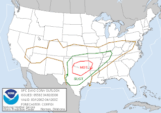 Tomorrow is a big day in the SPC's forecast. They have outlined Oklahoma (again...) and part of Texas to be in an area of moderate risk for severe weather. There is powerful wording with this one, as they show that the environment will be very unstable with an SBCAPE at or around 2500 J per kg!!! Haven't seen that kind of instability forecast since last year, looks like the season has arrived. The cap's as good as busted. Chasers should be abound...
 AN ENVIRONMENT FAVORABLE FOR SUSTAINED SUPERCELLS WITH VERY LARGE (SEVERE) HAIL...HIGH WIND AND TORNADOES
 Bf and I plan to visit family and friends up near Atlanta this weekend. Currently, the SPC has highlighted almost the entire state of Georgia to have severe weather on Saturday... a day 4 severe forecast... chasetunity!!! Yeah, yeah, so it's the squalled out leftovers of the exciting stuff they are playing with in Oklahoma and Texas tomorrow... but we could get a little something, something... you know how those embedded supercells can be.
We'll see what happens...
~Dewdrop
Showing posts with label 4 day outlook severe. Show all posts
Showing posts with label 4 day outlook severe. Show all posts
Wednesday, April 02, 2008
Oh, the weather outside is boring...


Subscribe to:
Posts (Atom)





















