Well, rain poured down in the Atlanta area yesterday causing the flash flooding that everyone feared, falling on already saturated ground, causing the rivers and creeks to crest above flood stage. Unfortunately, that is just an appetizer. 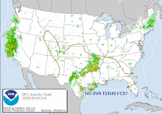 Another dose of flooding rain is rolling in tomorrow, which will put much of north Georgia under water. Now, that area of storms over on the west coast... guess what that is... It's the system formerly known as Super Typhoon Melor. That's right, the remnants of Melor have tracked all the way across the Pacific Ocean and have decided to pummel the west coast of the US with flooding rain. That area is preparing for mudslides. As if they didn't have their share of natural disaster with all the wild fires they endured over the summer.
We've had dreary skies and rain/drizzle in my neck of the woods, which seems to be taking its toll on people, that and the sticky humidity... I think we are ready for some colorful fall-like weather!
Have a superb day!!
~Dewdrop
Tuesday, October 13, 2009
Flooding and the leftovers


Thursday, October 08, 2009
Lenticulars!
 SKY WATCH FRIDAY time! Welcome all sky fans!!! I might not have time to respond to you, but I will try my best to visit!!!
Our hosts: Klaus Sandy Ivar Wren Louise Fishing Guy
Thanks, also,to Dot and Tom, who were instrumental in the success of this blogging event. You should definitely come fly with us! Once again, I am sharing some of the beauty that our great God blessed me with... Psalm 19:1
I have never seen lenticular clouds before, the lens or saucer shaped clouds that generally form over or around mountains. I live in south Georgia. There are no mountains, just trees and farms. I wasn't sure I would ever have the pleasure of experiencing a lenticular altocumulus cloud, but once again, our gracious God showed me...
The heavens declare the glory of God;
the skies proclaim the work of his hands. 
 I shot this lenticular cloud Saturday morning, while my wonderful groom was driving us to an event out of town.
 Lenticular clouds (Lenticularis), also known as "flying saucer clouds," "angelship clouds", "cloudships", "clouds of heaven", are stationary lens-shaped clouds that form at high altitudes, normally aligned perpendicular to the wind direction.
Lenticular clouds are the most common member of an unusual class of clouds that remain stationary while the wind blows through them. They are normally generated by mountains. They form because of two fundamental properties of air and water. First, when air is lifted and expanded, it cools. This is why temperature normally decreases with height. Second, as air cools, the amount of water it can hold decreases. If air that is already holding almost as much water vapor as it can hold is lifted and thus cooled, the water will condense out fairly promptly onto any particles that may be in the air, forming a cloud. If the air is dry to start with, the air has to be lifted much farther before a cloud forms. When the air descends again, it is warmed, and the cloud droplets evaporate.
~source Sometimes the air is forced into a wave pattern, generating what is known as a wave cloud. Wave clouds can look like strings of discs spreading out from the leeward side of the mountain. They can also form miniature waves which sometimes look exactly like a choppy sea. If you look around the cloud, you may see a geographical feature which is creating the conditions which lead to the formation of lenticular clouds. If you don't see a mountain or hill, there is probably a current of air running in the opposite direction to create a wave cloud.
~source
That aside, Melor made its way through Japan while we were sleeping, now just an extratropical depression. Sadly, two deaths are blamed on Typhoon Melor. Meanwhile, in the Atlantic Basin, the now Tropical Depression Henri (On-ree) is losing steam as he drifts through the Atlantic. A tropical wave on his heels shows little likelihood of development in the very hostile environment. Back in the states, we have a line of rain and thunderstorms literally inundating Missouri with torrential rains, leading to extensive flooding.

 Residents within areas of the flood watches and warnings should exercise extreme caution. Water levels can rise suddenly, easily sweeping cars and people away. If there is water over the roadway, Turn Around, Don't Drown™. You never know how deep the water is, or even whether or not the road is still there. Water can easily wash away overpasses. Don't become a rescue mission... or worse.
Have a safe day!
~Dewdrop
Friday, April 03, 2009
Moderate MAJOR Flooding in Lowndes County, Georgia
 (The above is of the same house [across from my wonderful gtb's parents] I captured the other day with the shed in the backyard flooded. The water has risen drastically with all the rain since Saturday.) What a day yesterday was... thunderstorms, literally all day and into the night... tornado warned cells racing toward my county at about 65 mph... and the rain. As it turned out, the only event here was a severe warned squall line that carried 45 mph gust, torrential downpours, and frequent lightning.
  When I arrived home, my power was out, as well as most of the northeast part of the county. I had heard bogus reports of a tornado spotted, but with it dark and as horrendous as the rain was (not to mention the lack of signature on radar), they wouldn't have seen it. I heard unconfirmed reports of trees down. My yard looked like a pond, and I live on a high spot in my neighborhood. Given the time and the fact that I had an errand that had to be taken care of, I took the long way (the road between me and where I was going was closed because of high water at the bridge), and got Mini-Dew some dinner since I can't cook without power. I spoke with the emergency manager, who informed me that the power outage was an open circuit that was being looked at... and headed home. During that 1 1/2 hour period, water rose over the main road leading to my house, causing flash floods. When I drove by this spot, the water level sat halfway up these vehicles.
  I could still see the road clearly... in fact, I hadn't realized it was water over the road until I was right on top of it. If ever you come upon a flooded area, turn around; don't drown.
My office works to collect relevant data to attach to geography. Yesterday, they were working in conjunction with the emergency manager to map the rise in water since the high water marks, all over town where flooding was occurring. The flood forecast, at that time was minor, and we were trying to make the case that the flooding was more significant than minor. Because of CoCoRaHS, I was brought into it...  [This is not a boat ramp... this is the neighbor's driveway and back yard.]
In a collaborative effort between the emergency manager, GIS, CoCoRaHS (that's me) and the Hydrologist at the National Weather Service in Tallahassee, the flood status level raised.  For some reason, initially, the expectation was that yesterday, the water had crested at about 19.5', but after getting 4.06" of rainfall (just here) through yesterday and last night... with the current observed stage at 22.9' (which is almost 10' over flood stage), the expectation is that the Withlacoochee River will crest tomorrow at 24.9', which will put the water level of the river at the bridge height on the road I had to go around; however, some water levels are already above the road...
  Bottom line is, today, the flood warning has been changed from minor to moderate in severity.
....FORECAST FLOODING CHANGED FROM MINOR TO MODERATE SEVERITY FOR THE WITHLACOOCHEE RIVER NEAR VALDOSTA AFFECTING LOWNDES COUNTY ...MODERATE FLOODING IS OCCURRING AND EXPECTED TO CONTINUE...
...THE COLD FRONT HAS MOVED THROUGH THE REGION. SEVERAL INCHES OF RAIN FELL ACROSS THE ENTIRE REGION OVER THE LAST FEW DAYS. THIS RAIN WILL MAKE ITS WAY TO THE RIVERS. THIS WILL CAUSE THE RIVERS TO CONTINUE TO RISE OVER THE NEXT SEVERAL DAYS...
WITHLACOOCHEE RIVER VALDOSTA FL STAGE: 13' OBSERVED STAGE: 22.9' (FRI 05 AM) SATURDAY: 24.9' SUNDAY: 22.9' MONDAY: 22.0' TUESDAY: 20.6'  Mission accomplished.
9:58AM: Flood forecast upgraded to major. 
...FORECAST FLOODING CHANGED FROM MODERATE TO MAJOR SEVERITY FOR THE WITHLACOOCHEE RIVER NEAR VALDOSTA AFFECTING LOWNDES COUNTY ...MODERATE FLOODING IS OCCURRING AND MAJOR FLOODING IS FORECAST...
... and rain forecasted for Sunday!
WITHLACOOCHEE RIVER VALDOSTA FL STAGE: 13' OBSERVED STAGE: 23.6' (FRI 09 AM) SATURDAY: 25.1' SUNDAY: 24.3' MONDAY: 23.4' TUESDAY: 22.5' WEDNESDAY: 21.4'
Have a great day! Stay dry!
~Dewdrop
Tuesday, March 17, 2009
Turn Around Don't Drown™
This week NOAA is promoting flood safety awareness and not a minute too soon. With major flooding along the Illinois River in Missouri, Indiana and Illinois, from the excessive rain, and drastic rise in temperatures causing rapid snow melt, flood safety is a very important topic. The above image links to a map showing the Advanced Hydrologic Prediction Service (AHPS) flood predictions according to gauge measurement. The AHPS works to advance river and flooding forecasts and other water information to work to protect life and property. Yes, it is very important that you know about flood dangers, which are very real and happen to be among the top weather related killers.
  Link to flooding statistics of 2007.
 The above shows the statistics regarding weather related deaths over the 10 year average and the 30 year average. You see that flooding is a great danger! In 30 year statistics, of the weather related deaths recorded (flood, lightning, tornado hurricane) over that period, the annual average is the highest for flooding. One important factor that I want you to notice is that the majority of flooding deaths occurred when people were in a vehicle or in the water. Today, NOAA has highlighted their chief flood related campaign as their flood safety awareness topic, "TURN AROUND, DON'T DROWN™!" Why do flood related deaths occur...?
The main reason is people underestimate the force and power of water.
It takes only six inches of fast flowing water to sweep you off your feet.
Water only two feet deep can float away most automobiles.
~source Here is a link to someTADD resources. It is a serious and real threat. If you see a flood covered road, it is for your own safety and your potential rescuers that you turn around to avoid being trapped in a current and swept away, leading to drowning. Water over roads can hide damage done to roads, where parts of roads have been washed away leaving them completely impassable, hazards left in the roadway, how strong the current is, or how potentially deep the flood water actually is. Floods can destroy roads. Floods can sweep away people and cars. Floods can kill. Over the past 30 years, floods have killed more people than any other recorded weather related threat.
Aside from that......NO TSTM AREAS FORECAST...
The SDS is killing me...
A RATHER QUIET WEATHER PATTERN IS IN PLACE ACROSS THE NATION TODAY WITH RELATIVELY WARM AND DRY CONDITIONS IN MOST AREAS. SCATTERED SHOWERS ARE POSSIBLE TODAY OVER SOUTH FL...AND ACROSS THE NORTHERN PLAINS. HOWEVER...THE THREAT OF LIGHTNING STRIKES IN BOTH AREAS APPEAR TOO LOW TO WARRANT AN OUTLOOK AT THIS TIME.
Have a great day! Sorry for the delay. Trouble getting an image to load.
~Dewdrop
Friday, February 06, 2009
Turn Around Don't Drown™
Well, as you see, much of the country was covered in freezing cold temperatures again this morning, with much of Georgia and Florida dealing with, yet another day of, much colder temperatures than what we are accustomed to...
 What an exceptionally cold winter we have had so far, with too many periods of longer than normal freezing conditions. In fact, on Thursday, some records were broken for low temperatures on that date within the County Warn Area for NWS-Tally. Look at my poor little rain gauge... all covered in frosty twirls. This is not what a rain gauge in south Georgia should look like, but it is pretty indicative of how cold the dew is...
 Fortunately, we are in for a temperature rebound soon. Great googaly moogaly, there is even a small area outlined with a slight risk for severe weather on the day 3 outlook. Way to go, Steve M., TX! Lucky dog.
Speaking of severe weather, it's time for me to discuss the next topic during Georgia's Severe Weather Awareness Week... FLOODING! According to the National Weather Service: Many people do not know this, but flooding kills more people than any other weather hazard.
 Heat is the number one weather-related killer worldwide, but flooding kills more people, here in the United States than any other weather hazard, and is, therefore, a very important topic to be informed about. Sadly, more than half of all those fatalities occur in vehicles. That is why it is so important that if you see flood waters, that you TURN AROUND, DON'T DROWN.
 A mere six inches of fast-moving flood water can knock over an adult. It takes only two feet of rushing water to carry away most vehicles. This includes pickups and SUVs
... and there is no telling how deep it is just looking at it! People have a tendency to underestimate the power and force of moving water.Flash floods are usually caused by slow moving thunderstorms or thunderstorms that move over the same area one after the other. These floods usually occur within 6 hours of heavy rainfall and are usually more life threatening as a result. Areas most prone to floods are mountainous streams and rivers, urban areas, low-lying areas, storm drains, and culverts.
What can you do to protect yourself and your loved ones from Flooding? (Thanks for asking!)
River flooding is caused by the gradual increase in the water level of river or creek. These floods usually occur seasonally with general rains, or with heavy rainfall from tropical systems. A good example of this flooding is the flooding that affected south Georgia after Tropical Storm Alberto in 1994.
1. Know what to listen for.
A Flood Watch or a Flash Flood Watch means that conditions have been detected that could lead to flooding of a certain area. A River Flood Warning or a Flash Flood Warning means that flooding is imminent and you should take action immediately. You can monitor the weather radio or any local radio or TV station to get the latest information.
2. If flooding occurs get to higher ground.
3. Avoid areas already flooding, especially if the water is fast flowing.
Do not attempt to cross flowing streams. Road beds may be washed out due to the flooding. Never try to cross flooded roadways. Turn Around Don't Drown™!!
4. If your vehicle is suddenly caught in rising water, leave it immediately and seek higher ground. Turn Around Don't Drown™!!
5. Be especially cautious at night when it is harder to see flood dangers. Turn Around Don't Drown™!!
6. Turn Around Don't Drown™!!
Yep, that covers it!
Have a great weekend!
~Dewdrop





















