 SKY WATCH FRIDAY time! I am busy busy with stimulus yuck, so I might not get a chance to say hi. Please don't take offense. Our hosts: Klaus Sandy Ivar Wren Louise Fishing Guy
Thanks, also,to Dot and Tom, who were instrumental in the success of this blogging event. You should definitely come fly with us!
In honor of our summertime-like thunderstorms, I give you cloud to cloud lightning at night.
 This morning, I awoke to flashes of lightning, no thunder, just bright flashes of light, lighting up the dawning morning sky. Just moments ago (6:40AM or so), the National Weather Service in Jacksonville issued a severe thunderstorm warning including the county to my east, indicating that hail and wind were a definite threat from the supercell that was pressing southward out of Fargo, Georgia.
Lightning without sound is referred to as "heat lightning". My parents used to tell me that "heat lightning" was caused by extreme heat and it's harmless. Many people actually believe that heat lightning is a "safe lightning", not necessarily true. Well, it is called heat lightning, but that really is a misnomer. Heat lightning is lightning with no audible thunder. It's not because it has no sound, but because it is too far away or changes in densities in the air affect whether or not the sound of the thunder is able to refract to us, so we can hear it. If a lightning strike is a sufficient distance from the observer, sound from the strike will not be heard. These "silent bolts" are called heat lightning.
The movement of sound in the atmosphere depends on the atmospheric properties of the air such as temperature and density. Because temperature and density change with height, the sound of thunder is refracted through the troposphere. This refraction results in spaces of volume in which the thunder does not propagate through.  The sound of thunder often reflects off the earth's surface. The rumbling sound from thunder is partly due to reflections off the earth's surface. This reflection and refraction leaves voids where thunder can not be heard (click here for an applet of this by Tom Whittaker.) Therefore, the Earth's curvature also contributes to people far from the strike from not hearing it. Thunder is more likely to be bounced off the earth's surface before it reaches an observer far from the strike. The reflection and refraction in the troposphere determines who hears the strike and who doesn't.
The term "heat" in heat lighting has little to do with temperature. Since heat lightning is most likely to be seen in association with air mass thunderstorms in the warm season, the term "heat" may have been used because these flashes are often seen when surface temperatures are warm.
~Meteorologist, Jeff Haby As I said though, it is possible for density and temperature to affect whether or not the sound of thunder travels through the air, so potentially dangerous nearby thunderstorms can go unheard (not too common). So, "if you hear thunder, you are close enough to be struck" AND if you see nearby lightning, get inside! Lightning is a real and serious threat, always.
  Lightning strikes can (and do) occur outside of the audible thunder zone. Click on the above image for lightning facts about strikes "out of the clear blue sky". Play it safe. If there is a thunderstorm anywhere nearby, get indoors.
Speaking of thunderstorms, looks like a major concern for hefty severe weather, including a heightened risk for tornadoes. The Storm Prediction Center is expecting the next two days to be among the most active of the year for severe weather. 

Folks in the northern plains, including Wisconsin should be very aware of the weather, and take any warnings seriously, as tornadoes are a serious threat today.SEVERAL ROUNDS OF SEVERE STORMS WILL LIKELY AFFECT THIS AREA... COUPLED WITH STRONG DAYTIME HEATING AND DEWPOINTS IN THE MID 70S WILL YIELD EXTREME INSTABILITY WITH MLCAPE VALUES APPROACHING 5000 J/KG AND LITTLE CAP. FORECAST SOUNDINGS OVER SOUTHERN MN AND NORTHERN IA INDICATE THE RISK OF INTENSE SUPERCELLS FORMING OVER THIS AREA CAPABLE OF VERY LARGE HAIL...DAMAGING WINDS...AND PERHAPS SIGNIFICANT TORNADOES.
Have a safe day... turn on your weather radios! (That includes you, sis!)
12:00pmEDT: Talk about Dewvoid... those watches might has well have been 1000 miles away... I am between them. Alas, the tornado probabilities have been redrawn...
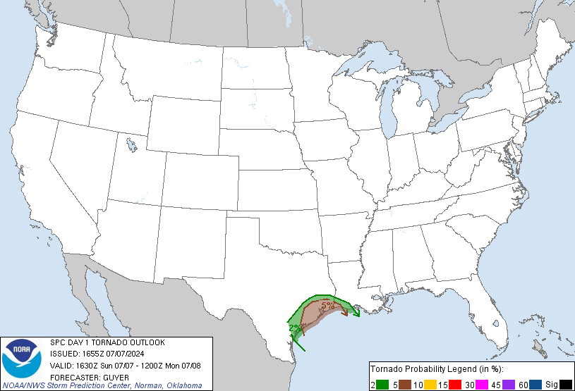 ... and we are within an area with a chance of tornadoes...
Latest update: Apparently, I typed too loudly... Dewvoid, back in action.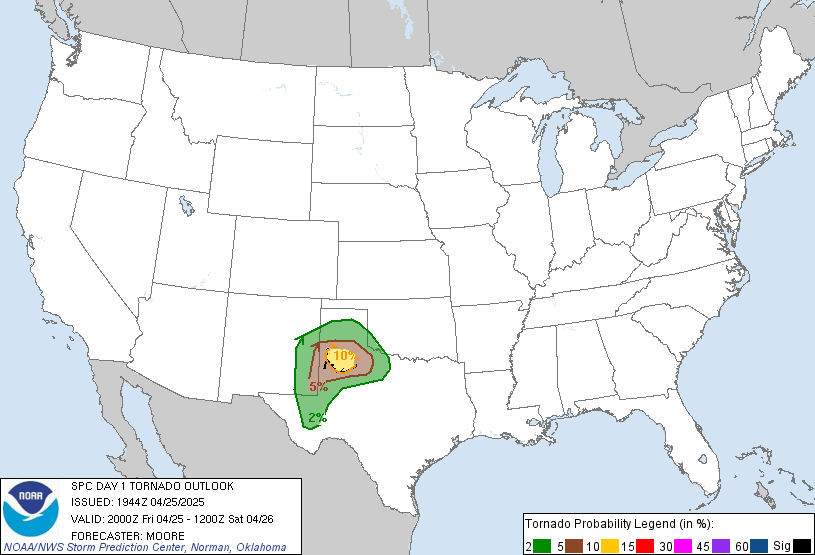 ~Dewdrop
Thursday, June 18, 2009
What is heat lightning???


Sunday, April 05, 2009
Moderate to major flooding in Valdosta continues...
 On account of my wonderful gtb becoming my groom this weekend, I am out of the area, so I don't have current pictures of the flooding in the Valdosta area, but I have gotten a bunch of reports. Many of the roads are already closed, due to moderate to major flooding and concerns about the integrity of the bridges over rushing water. Gornto Road, Troupville Road, Skipper Bridge Road, Highway 84, Highway 133, Shiloh Road, Park Lane, Meadowbrook Lane, Franklin Bridge Road and many, many more are closed. I know a part of I75 was actually covered in water on the way up. Unfortunately, I just got the CodeRED message while on the side of a mountain that water rise is expected to continue and gain another foot or two in water raise... and with upcoming storms this afternoon and evening, they are expecting another inch or two of rain fall... Many, many homes are flooded. People are being told to evacuate to the emergency shelter at Mathis Auditorium before water levels rise to dangerous levels at your home. Do not drive on flooded roads!!!! If you stay in your home past flooding, you endanger rescue crews. People are being advised not to travel if possible. I have never seen it this bad or heard of it ever being this bad. A State of Emergency has been declared by the governor. If you have any information to share, please share it in comments or feel free to email the to me to post at dewdrop_in_sga@yahoo.com.
Link to Flood Warning
Road Closure Article
Overcome by Water article
I'll be posting wedding and waterfall shots soon. Meanwhile, the Dewvoid holds strong presenting tornadoes back home while I am away... and the "severe event" once expected here has fizzled to a baby squall line.TORNADO REPORTS
When Dewdrop's away...
4 E ALAPAHA BERRIEN GA
POSSIBLE BRIEF TORNADO TOUCHDOWN JUST WEST OF WILLACOOCHEE. (TAE)
WILLACOOCHEE ATKINSON GA
A STORM SPOTTER REPORTED A POSSIBLE TORNADO ON THE GROUND NEAR HIGHWAY 90 JUST SOUTH OF WILLACOOCHEE. NO FURTHER CONFIRMATION OR DAMAGE HAS BEEN REPORTED. (JAX)
1 N BLACKSHEAR PIERCE GA
A STORM SPOTTER REPORT OF A POSSIBLE TORNADO IN BLACKSHEAR...60 TO 70 MPH WINDS AND DIME SIZE HAIL. (JAX)
Link to slideshow of flooded areas on VDTimes site (includes descriptions of locations and days)
Link to aerial views of Valdosta area during flood posted in VD Times article.Latest on flooding/recovery info from Lowndes County Emergency Management:
~Dewdrop
From today at the Lowndes County SITREP meeting:
1. Valdosta has created a flood information hotline 671-2400. Personnel
can call to report damage, inquire about school and road closures.
2. Florida State Patrol is expected to close parts of I-10 near the Suwannee
River as the crest moves south. Personnel traveling west of I-75 on I-10
should call the flood information center before committing to any travel.
3. Roll off dumpsters have been placed in flooded areas for home owner use.
If there are no dumpster, personnel should move trash to the right of way
for disposal.
4. Gornto Road remains closed, but Cat Creek and Skipper Bridge are expected
to reopen today.
5. Media Comm is flooded out and many customers are without cable, internet
and phone service. Service should be out through the Phase I exercise.
6. Valdosta Emergency Managers have asked that personnel do not
"self-deploy" to aid in the cleanup efforts. All volunteers should call the
information hotline to sign up for coordinated recovery teams.
7. As flood waters recede more bridges and roads will reopen as they are
inspected. Please continue to observe the posted closing and DO NOT drive
around any barricades.
8. Free water testing is available from the city of Valdosta for personnel
with wells. Call the information center for further instructions. The city
water is safe as the aquifer is over 200' deep and the water is continually
being monitored

Friday, April 03, 2009
Moderate MAJOR Flooding in Lowndes County, Georgia
 (The above is of the same house [across from my wonderful gtb's parents] I captured the other day with the shed in the backyard flooded. The water has risen drastically with all the rain since Saturday.) What a day yesterday was... thunderstorms, literally all day and into the night... tornado warned cells racing toward my county at about 65 mph... and the rain. As it turned out, the only event here was a severe warned squall line that carried 45 mph gust, torrential downpours, and frequent lightning.
  When I arrived home, my power was out, as well as most of the northeast part of the county. I had heard bogus reports of a tornado spotted, but with it dark and as horrendous as the rain was (not to mention the lack of signature on radar), they wouldn't have seen it. I heard unconfirmed reports of trees down. My yard looked like a pond, and I live on a high spot in my neighborhood. Given the time and the fact that I had an errand that had to be taken care of, I took the long way (the road between me and where I was going was closed because of high water at the bridge), and got Mini-Dew some dinner since I can't cook without power. I spoke with the emergency manager, who informed me that the power outage was an open circuit that was being looked at... and headed home. During that 1 1/2 hour period, water rose over the main road leading to my house, causing flash floods. When I drove by this spot, the water level sat halfway up these vehicles.
  I could still see the road clearly... in fact, I hadn't realized it was water over the road until I was right on top of it. If ever you come upon a flooded area, turn around; don't drown.
My office works to collect relevant data to attach to geography. Yesterday, they were working in conjunction with the emergency manager to map the rise in water since the high water marks, all over town where flooding was occurring. The flood forecast, at that time was minor, and we were trying to make the case that the flooding was more significant than minor. Because of CoCoRaHS, I was brought into it...  [This is not a boat ramp... this is the neighbor's driveway and back yard.]
In a collaborative effort between the emergency manager, GIS, CoCoRaHS (that's me) and the Hydrologist at the National Weather Service in Tallahassee, the flood status level raised.  For some reason, initially, the expectation was that yesterday, the water had crested at about 19.5', but after getting 4.06" of rainfall (just here) through yesterday and last night... with the current observed stage at 22.9' (which is almost 10' over flood stage), the expectation is that the Withlacoochee River will crest tomorrow at 24.9', which will put the water level of the river at the bridge height on the road I had to go around; however, some water levels are already above the road...
  Bottom line is, today, the flood warning has been changed from minor to moderate in severity.
....FORECAST FLOODING CHANGED FROM MINOR TO MODERATE SEVERITY FOR THE WITHLACOOCHEE RIVER NEAR VALDOSTA AFFECTING LOWNDES COUNTY ...MODERATE FLOODING IS OCCURRING AND EXPECTED TO CONTINUE...
...THE COLD FRONT HAS MOVED THROUGH THE REGION. SEVERAL INCHES OF RAIN FELL ACROSS THE ENTIRE REGION OVER THE LAST FEW DAYS. THIS RAIN WILL MAKE ITS WAY TO THE RIVERS. THIS WILL CAUSE THE RIVERS TO CONTINUE TO RISE OVER THE NEXT SEVERAL DAYS...
WITHLACOOCHEE RIVER VALDOSTA FL STAGE: 13' OBSERVED STAGE: 22.9' (FRI 05 AM) SATURDAY: 24.9' SUNDAY: 22.9' MONDAY: 22.0' TUESDAY: 20.6'  Mission accomplished.
9:58AM: Flood forecast upgraded to major. 
...FORECAST FLOODING CHANGED FROM MODERATE TO MAJOR SEVERITY FOR THE WITHLACOOCHEE RIVER NEAR VALDOSTA AFFECTING LOWNDES COUNTY ...MODERATE FLOODING IS OCCURRING AND MAJOR FLOODING IS FORECAST...
... and rain forecasted for Sunday!
WITHLACOOCHEE RIVER VALDOSTA FL STAGE: 13' OBSERVED STAGE: 23.6' (FRI 09 AM) SATURDAY: 25.1' SUNDAY: 24.3' MONDAY: 23.4' TUESDAY: 22.5' WEDNESDAY: 21.4'
Have a great day! Stay dry!
~Dewdrop





















