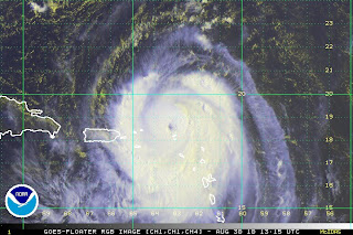
My, oh my… Hurricane Danielle did take the turn and is now headed out to sea, where she will only impact the Titanic expedition and other ship traffic. She passed far away from the US, leaving us with strong rip currents, which resulted in numerous water rescues and at least one death, as a swimmer was carried out in the current. At the strongest, Hurricane Danielle was a category 4 hurricane, and she is now losing her tropical characteristics as she soars into the frigid northern Atlantic.  Hot on her heels though, with must less impactful patterns, is now Hurricane Earl. Already Hurricane Earl, a strengthening (though already strong) category 2 storm, is forecast to strengthen after leaving its impact on the Lesser Antilles.
  The concerns now are for the east coast of the United States. Apparently, each model run puts Earl further and further west, making an east coast landfall more and more likely. I know TWC has plans to be in Boston. Unfortunately, hot on the heels of Hurricane Earl, is yet another tropical wave with a 90% certainty of development into something over the next 48 hours, and behind that, yet another wave.
  It’s a parade of tropical action.
Have a beautiful day!
~Dewdrop
Monday, August 30, 2010
Next up, Hurricane Earl takes center stage!
Subscribe to:
Post Comments (Atom)


No comments:
Post a Comment
Dew comment, please...