 Hurricane Earl, now a very powerful category 4 storm, refused the dry air that infused earlier this morning, and came through it just a strong. I am concerned for the impact that Hurricane Earl will have on the coast. The good news is that right now, he is a fast moving storm, so the impact won’t last for a long time, but the size, the power and the proximity to land will impact interests along the east coast, whether he comes ashore or not. Already States of Emergency have been declared from North Carolina, up into Maryland. They are still not ruling out a landfall. We’ve seen storms do very unpredictable things as they approach land. A forecast is just an expectation. It is imperative that people prepare for the unexpected. Only 11 mph distinguish between what Earl is now and a catastrophic category 5 hurricane. Sadly, I think some level of devastation might be unavoidable. I pray that people are heeding the evacuation orders, that they have rushed preparations to completion and that impact is less than expected. Go east, Earl!
Fortunately, it looks like Tropical Storm Fiona is too caught up in the outflow of Earl to make much of an impact. The expectation there is that Fiona will quickly move eastward, possibly moving over Bermuda, but she should not pose a threat to the US coastline.  The one many have a hard eye on is Tropical Storm Gaston. He is currently just hanging out in the Atlantic, but models are doing some scary things with that system, potentially even moving him into the warm waters of the Gulf of Mexico. That is far from ideal. He is already forecast to become a hurricane before reaching the Lesser Antilles. Everyone has an eye on Gaston… that is while keeping the other on Earl.
 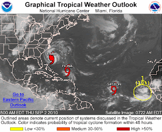 I’m not even going to get into the next wave that has rolled off the coast of Africa. Could we have Hermine???
Have a beautiful day.
~Dewdrop
Thursday, September 02, 2010
Africa just keeps waving at us!!
Wednesday, September 01, 2010
Busy season...
As Hurricane Earl breezes by the Bahamas, leaving everyone along the east coast wonder what type of impact he will have on their Labor Day plans, Tropical Storm Fiona starts to intensify.  Having placed some distance between herself and the powerful category 3, Fiona has had an opportunity to strengthen slightly. The forecast does not have her reaching hurricane strength, but they do have YET ANOTHER problem area highlighted for another wave that has rolled off the African coast, where they are giving that one an 80% likelihood of development into a tropical system. We could see the beginnings of Gaston.
 Back to Earl though, Hurricane Earl, a powerful category 3 storm, just downgraded to a category 3 storm after losing a bit of his bite through an eye-wall replacement cycle. Unfortunately, it appears that Hurricane Earl has regrouped and the eye-wall looks as strong as ever, which would lend to some likely intensification, but that is a typical ongoing process for major hurricanes, fluctuations in strength.
  All eyes are on Earl as he races across the Atlantic, the cone of possibilities slowly creeping westward with each model run, which places a more imminent threat on interests along the coast. Anyway you look at it, the east coast (and much of it) will be impacted by Hurricane Earl, just how badly is yet to be seen.
Have a great day!
~Dewdrop
Tuesday, August 31, 2010
Hurricane Earl, a powerful hurricane!
 Earl is a very powerful category 4 hurricane, with an intensely low pressure. Hurricane Earl is a force, and people all up and down the east coast should be on guard and ready just in case his course moves westward. Even in the best case scenario, impact from Hurricane Earl will be felt with waves, winds and rip currents. It is possible that Hurricane Earl will move over the Outer Banks as a major hurricane. Then, there is a chance he could move over Massachusetts. Be watchful and vigilant.
 Incidentally, we also have Tropical Storm Fiona, and another wave behind her that could become something. I think Fiona will suffer in Earl's wake, but who knows for sure?
Stay tuned!
~Dewdrop
Monday, August 30, 2010
Next up, Hurricane Earl takes center stage!
My, oh my… Hurricane Danielle did take the turn and is now headed out to sea, where she will only impact the Titanic expedition and other ship traffic. She passed far away from the US, leaving us with strong rip currents, which resulted in numerous water rescues and at least one death, as a swimmer was carried out in the current. At the strongest, Hurricane Danielle was a category 4 hurricane, and she is now losing her tropical characteristics as she soars into the frigid northern Atlantic. Hot on her heels though, with must less impactful patterns, is now Hurricane Earl. Already Hurricane Earl, a strengthening (though already strong) category 2 storm, is forecast to strengthen after leaving its impact on the Lesser Antilles.  The concerns now are for the east coast of the United States. Apparently, each model run puts Earl further and further west, making an east coast landfall more and more likely. I know TWC has plans to be in Boston. Unfortunately, hot on the heels of Hurricane Earl, is yet another tropical wave with a 90% certainty of development into something over the next 48 hours, and behind that, yet another wave.
  It’s a parade of tropical action.
Have a beautiful day!
~Dewdrop


