 SKY WATCH FRIDAY time! Thanks to Dot and Tom, never forgotten founders of this great event. Come on, come fly with us!
Thanks to hosts: Klaus Sandy Sylvia Wren Louise Fishing Guy Monday, scrubbed – mechanical (gas leaks). Tuesday, scrubbed – electrical. Wednesday, scrubbed – residual electrical. Thursday, scrubbed – wet weather. Friday, most likely scrubbed – windy weather. Saturday… I can’t go!!! Sunday – window closes… So, then, I pull up my Yahoo! to check messages and you may or may not know, but the sign on screen usually has some big image, usually of some interesting geeky person. This time, with the people at Yahoo! no doubt, mocking me, this was their welcome screen:
 How rude! In all honesty, when the Wednesday launch (which was our 2nd best opportunity to experience it) was scrubbed, I knew that today’s weather would be a barrier, and even after NASA’s lengthy meeting yesterday, I knew that weather would prevent a launch today.
  One, they have 100% chance of showers and thunderstorms… Two, the clouds are there regardless. There’s no way they would launch that thing in those conditions. Problem is, it’s a cold front working its way in. That means on the other side of this much needed rain, we will see crisp, beautiful, blue skies… and wind. Wind played a role in the Challenger disaster (Beginning at about T+37, the shuttle experienced a series of wind shear events over the next 27 seconds that were the strongest recorded to date in the shuttle program. ~Wikipedia)… so they will not launch on Friday. 70% chance of a go, per this article, but NASA puts it at 60% - link. I just want to see a launch up close, is that so wrong???
Let us remember to pray for Haiti, as yet another natural disaster threatens to steal lives in that depressed country, as the potential Hurricane Tomas makes his way toward them. Earthquake, Cholera, now potential mudslide inducing rain... with Tomas. God be with them...
~Dewdrop
Thursday, November 04, 2010
Scrubbed... again.
Tuesday, November 02, 2010
Spooky...
So, we had yet another terrific Halloween. It was a little cram packed full, and NASA knocked the wind out of my sails by rescheduling the launch of the Space Shuttle Discovery, but we had a terrific time. We covered the traditionals, complete with trip to pumpkin patch and carving. 
 We had a terrific Halloween party packed with great fun and yummy food, and my wonderful groom and I got to show our true colors as I portrayed (get this) a weather geek and my wonderful groom portrayed a nerd. I know, so far out of character for us. It was so much fun!
 Tomorrow, we hope, the shuttle is expected to launch. Unfortunately, where the PERFECT forecast prevailed on Monday (not to mention the timing was PERFECT, but I’m not bitter), it looks like the launch will be contending with some cloudiness and chance showers. I dread the thought of going all the way down there to have the blasted (punny) thing cancelled. This is an item on my "Must-Dew-before-I-die" list, and with our much esteemed (cough cough) president swiping funds from this beloved program, I am running out of chances. Somehow privatizing the space program will save money, per President Obama; yet, public health is a good idea. It’s a shame they perform lobotomies on all politicians before they take office. I digress...
My heart aches for Haitians as they face yet another wave of potential disaster, with the potential Hurricane Tomas breathing down their necks.  A voluntary evacuation has been put out there… where are they supposed to go… and pray tell, how are they supposed to get there?? I think I'm grumpy. I blame NASA.
Have a bright day.
~Dewdrop
Thursday, October 21, 2010
Seasonal Fog
SKY WATCH FRIDAY time! Thanks to Dot and Tom, never forgotten founders of this great event. Come on, come fly with us!
Thanks to hosts: Klaus Sandy Sylvia Wren Louise Fishing Guy The fog has been dense each morning, as we are entering into the fall season. I love the way the sunlight tries to pierce the fog, creating dramatic scenes on my way to the office. Don't be surprised if you pass me along the road from time to time with the camera hanging out the window capturing a breath-taking shot. Most people look at me like I have two heads. Nope... just revelling in God's creation. I do that a lot. This was the view I had the other morning, while I was leaving my neighborhood. What a great way to start the day!
Though I've been keeping an eye on Typhoon Megi over by China (I have a dear friend over there in Hong Kong - she is not worried.), my heart is usually in the Atlantic Basin with regard to tropical activity.  As of the 11AM advisory, we have Tropical Storm Richard. Tropical Storm Richard is our 17th named storm of the season, and it is one that has a slight chance of hitting the U.S. The models are sort of all over the place with him, but the general consensus is that he will strengthen. Time will tell. Keep an eye on him if you live near water... how's that?
Have a bright sunshine-y day!
~Dewdrop
Thursday, October 14, 2010
Blue skies...
SKY WATCH FRIDAY time! Thanks to Dot and Tom, never forgotten founders of this great event. Come on, come fly with us!
Thanks to hosts: Klaus Sandy Sylvia Wren Louise Fishing Guy
My wonderful groom and I took a wonderful butterfly flight inspired adventure over the weekend. We had a great time just chasing life and laughter. We saw so much, but here are a couple of the skies from that trip that I want to share (in light of the monotonous blue skies we've been experiencing here-I wanted to get a little creative with what's in the sky.)
 There was also just some nice scenery and stuff to enjoy along the way. Here are a couple of my favorites.

I'd talk about weather, but I don't want to get people all riled up about nothing. The once strong little Hurricane Paula is now just a tropical storm over Cuba... no worries, Florida.
Have a brilliant day!
~Dewdrop
Thursday, September 30, 2010
Have a bright, SUNflowery day!
SKY WATCH FRIDAY time! Thanks to Dot and Tom, never forgotten founders of this great event. Come on, come fly with us!
Thanks to hosts: Klaus Sandy Sylvia Wren Louise Fishing Guy
For Skywatch Friday, I want to post a few inspirational skies and one interesting sky. The first was just a powerful homecoming sky! What a beautiful way for the Lord to welcome me “home” after a dreary day. I snapped this shot driving into my neighborhood!
The next is just an amazing sky on fire shot, one summer evening. I love it when that happens!
The last one, I took Monday. We had some crazy weather with severe potential throughout the day, and I looked around to notice this eerie yellow/green sky after a hard rain. Of course, me and my optimism were seeking out some slight sign of rotation to no avail, but the sky was notable to the point where people talked about the eerie yellow/green sky all day, even kids.
What a tropical mess! Tropical Storm Nicole was such for a matter of hours, but between her and the non-tropical low over the east coast, rain has been and will be unrelenting. We had a line of storms trained over us for the ENTIRE day yesterday! It was some obscure little lost line of storms that literally started before work and didn’t stop until after I left. The low pressure system over the east coast was sucking all the moisture out of Nicole and just inundating everybody. We survived it. It was actually nice to have such rain after such a long spell without. My thoughts turn to the central coast though. They just had that frontal system pass through which offered up record rainfall 10+” in a day. Now, they are experiencing a steady stream of drenching rain… they are facing 20+” in 3-4 days time. That is deadly flooding potential.  Incidentally, flooding is the leading cause of weather-related deaths in the U.S., with approximately 93 deaths per year (the 30 year average). It is so important that if you see water over a road, you do NOT attempt to drive in it. Turn Around, Don’t Drown™. I can assure you that some of the infrastructure of those areas cannot support that much rain, in that short of a time. This is a deadly recipe…
  I know it’s totally off the subject, but I wanted to share with you that my wonderful groom surprised me with a beautiful (weather-related… SUNflowers) bouquet of flowers yesterday, in celebration of our 3-year Date-iversary. I am so blessed to have him to share my life with!! Definitely a heart smile...
Have a glorious day!
~Dewdrop
Thursday, September 23, 2010
Could we have the beginnings of Matthew???
SKY WATCH FRIDAY time! Thanks to Dot and Tom, never forgotten founders of this great event. Come on, come fly with us!
Thanks to hosts: Klaus Sandy Sylvia Wren Louise Fishing Guy
 Well, here we are facing the highly likely development of Matthew in the southeastern Caribbean. This is one that has piqued the interest of many, as many models have brought this disturbance into the Gulf of Mexico. Tropical Depression Lisa is barely churning in the far eastern Atlantic.
  The remnants of Julia are trying to act organized, but it’s the low pressure in the Caribbean that has everyone in a tizzy. Tropical Depression 15 will likely take center stage as a US media hog by the end of the day.
Here is a sky shot for your soul… A sunset not too long ago...
Have a great day!
~Dewdrop
Friday, September 10, 2010
Here I am...
OK, so I've been out of the loop for the last week. I had a tonsillectomy on Tuesday, which really sucked the life out of me. I am just now starting to feel somewhat like myself, so I figured I would pop in and say hello. During my absence, we had two more named storms pop up. Tropical Storm Hermine was actually a remnant of Pacific storm 11E, but it crossed over into the Gulf before being named, so it earned the name Hermine and inundated Texas with way too much rain, causing devastatingly deadly flooding. It also spawned some tornadoes. Now, we have Tropical Depression Igor way out in the Atlantic, expected to regain strength. ... then, there is the area in the Caribbean, which has a slight chance of development. When that season kicked in, it kicked in with a bang.
I'm going back to bed.
~Dewdrop
Thursday, September 02, 2010
Africa just keeps waving at us!!
 Hurricane Earl, now a very powerful category 4 storm, refused the dry air that infused earlier this morning, and came through it just a strong. I am concerned for the impact that Hurricane Earl will have on the coast. The good news is that right now, he is a fast moving storm, so the impact won’t last for a long time, but the size, the power and the proximity to land will impact interests along the east coast, whether he comes ashore or not. Already States of Emergency have been declared from North Carolina, up into Maryland. They are still not ruling out a landfall. We’ve seen storms do very unpredictable things as they approach land. A forecast is just an expectation. It is imperative that people prepare for the unexpected. Only 11 mph distinguish between what Earl is now and a catastrophic category 5 hurricane. Sadly, I think some level of devastation might be unavoidable. I pray that people are heeding the evacuation orders, that they have rushed preparations to completion and that impact is less than expected. Go east, Earl!
Fortunately, it looks like Tropical Storm Fiona is too caught up in the outflow of Earl to make much of an impact. The expectation there is that Fiona will quickly move eastward, possibly moving over Bermuda, but she should not pose a threat to the US coastline.  The one many have a hard eye on is Tropical Storm Gaston. He is currently just hanging out in the Atlantic, but models are doing some scary things with that system, potentially even moving him into the warm waters of the Gulf of Mexico. That is far from ideal. He is already forecast to become a hurricane before reaching the Lesser Antilles. Everyone has an eye on Gaston… that is while keeping the other on Earl.
 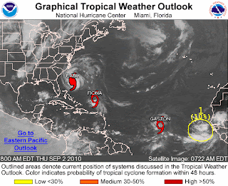 I’m not even going to get into the next wave that has rolled off the coast of Africa. Could we have Hermine???
Have a beautiful day.
~Dewdrop
Wednesday, September 01, 2010
Busy season...
As Hurricane Earl breezes by the Bahamas, leaving everyone along the east coast wonder what type of impact he will have on their Labor Day plans, Tropical Storm Fiona starts to intensify.  Having placed some distance between herself and the powerful category 3, Fiona has had an opportunity to strengthen slightly. The forecast does not have her reaching hurricane strength, but they do have YET ANOTHER problem area highlighted for another wave that has rolled off the African coast, where they are giving that one an 80% likelihood of development into a tropical system. We could see the beginnings of Gaston.
 Back to Earl though, Hurricane Earl, a powerful category 3 storm, just downgraded to a category 3 storm after losing a bit of his bite through an eye-wall replacement cycle. Unfortunately, it appears that Hurricane Earl has regrouped and the eye-wall looks as strong as ever, which would lend to some likely intensification, but that is a typical ongoing process for major hurricanes, fluctuations in strength.
  All eyes are on Earl as he races across the Atlantic, the cone of possibilities slowly creeping westward with each model run, which places a more imminent threat on interests along the coast. Anyway you look at it, the east coast (and much of it) will be impacted by Hurricane Earl, just how badly is yet to be seen.
Have a great day!
~Dewdrop
Tuesday, August 31, 2010
Hurricane Earl, a powerful hurricane!
 Earl is a very powerful category 4 hurricane, with an intensely low pressure. Hurricane Earl is a force, and people all up and down the east coast should be on guard and ready just in case his course moves westward. Even in the best case scenario, impact from Hurricane Earl will be felt with waves, winds and rip currents. It is possible that Hurricane Earl will move over the Outer Banks as a major hurricane. Then, there is a chance he could move over Massachusetts. Be watchful and vigilant.
 Incidentally, we also have Tropical Storm Fiona, and another wave behind her that could become something. I think Fiona will suffer in Earl's wake, but who knows for sure?
Stay tuned!
~Dewdrop
Monday, August 30, 2010
Next up, Hurricane Earl takes center stage!
My, oh my… Hurricane Danielle did take the turn and is now headed out to sea, where she will only impact the Titanic expedition and other ship traffic. She passed far away from the US, leaving us with strong rip currents, which resulted in numerous water rescues and at least one death, as a swimmer was carried out in the current. At the strongest, Hurricane Danielle was a category 4 hurricane, and she is now losing her tropical characteristics as she soars into the frigid northern Atlantic. Hot on her heels though, with must less impactful patterns, is now Hurricane Earl. Already Hurricane Earl, a strengthening (though already strong) category 2 storm, is forecast to strengthen after leaving its impact on the Lesser Antilles.  The concerns now are for the east coast of the United States. Apparently, each model run puts Earl further and further west, making an east coast landfall more and more likely. I know TWC has plans to be in Boston. Unfortunately, hot on the heels of Hurricane Earl, is yet another tropical wave with a 90% certainty of development into something over the next 48 hours, and behind that, yet another wave.
  It’s a parade of tropical action.
Have a beautiful day!
~Dewdrop
Thursday, August 26, 2010
The Majesty of His Power
SKY WATCH FRIDAY time! Thanks to Dot and Tom, never forgotten founders of this great event. Come on, come fly with us!
Thanks to hosts: Klaus Sandy Sylvia Wren Louise Fishing Guy
As I was saying, hurricane season is not over till it's over. We've now got a 1,2,3 line up of tropical action, all siblings off the coast of Africa barreling across the Atlantic Ocean. 
 Hurricane Danielle, now, once again a category 2 hurricane after some interaction with dry air has rebounded to be quite a storm, now showing indications of eyewall development. She is actually forecast to become a major hurricane, but I would expect her to become a fish storm, staying out to sea. Unfortunately, her little brother, Tropical Storm Earl, hot on her heels, is also forecast to get close to major hurricane strength, but he is expected to take a more southern track, which makes him a contender for some US action. I can almost hear the headlines... "Goodbye Earl!" "Earl's Gotta Die!" What a storm to impact the US... sigh. The third system, still just is wave (an impressive wave!), is hot off the coast of Africa, but some are already talking Fiona...
 It looks pretty impressive to me!
Tuesday was a crazy day for me. I had a wonderful afternoon excursion over lunch with my wonderful groom, and we went and explored in the jeep some! It was yet another great adventure for the two of us. We saw some really interesting things along the way including crews working to break down some rail cars that had de-railed. 
 I had never seen that before, so it was really neat.
  Then, I went to the doctor’s and got some icky news about a test he wants to run. I’ll survive it, but I am not excited about it. As I was leaving from Wally World, someone backed into my van… bumped in the side door. It’s only cosmetic… no one was injured and the mechanics of the door were unaffected, but seriously… what a day!
  I had a great meeting at church after that, but then, when I went to pick up Mini-Dew from practice, the sky had a hint of mammatus clouds popping. Of course, I stuck around out there, shooting a few pics until they were no longer visible. The pretty much fizzled out, just in time for sunset. Doesn’t that figure? I went in to get Mini-Dew and when I came out… KAPLOW!
 ... and then it followed me home!!! What a spectacular demonstration of God's awesomeness. He has a beautiful way of encouraging me, in the perfect way. I love my little love letters from God! Wasn’t it sensational?!
Have a mammatus-ful day!
~Dewdrop
Wednesday, August 18, 2010
It ain't over, till it's over!
I have heard much ho-humness regarding this year’s hurricane season. TWC is acting like it’s a lost season. Some chaser friends are reminiscing about days gone-by.
We are just now entering the peak of hurricane season. It is not terribly common to have significant activity in June and July. Unfortunately, our memories return to 2004 and 2005 and use that as a the basis for comparison and judge that the season is virtually over. The season is not over folks, and please realize that ANYTHING can happen. So, we’ve had a couple of years with no real US impact… what a blessing!!! The people of the Atlantic and Gulf Coasts should breathe a sigh of relief and use that money saved to prepare for the ones that don’t end up missing them.
Do you realize that Hurricane Andrew, the third most powerful hurricane to make landfall in the US, formed in mid-August?! That’s right, you know, where we are right now… major hurricane, catastrophic hurricane, which made landfall in the US and devastated that region. It only takes one.  Let’s consider last year, 2009, we had 9 named storms that year. At this time last year, we were on Hurricane Bill, which thanks to God, missed the United States. That doesn’t mean it wasn’t a very powerful category 4 hurricane because it very much was. Unfortunately, we did still have a US death related to Hurricane Bill up in Maine, closer to where landfall did occur. We are already looking at 3 named storms this season. At this point, we are looking to the tropics, and some are thinking “What a boring hurricane season!”… “Boy, were those forecasters off their rockers or what?!”… “El nino? HA!” Well, I say, it ain’t over till it’s over. Stay tuned.
  As I type a nice big wave is about to eject into the Atlantic off the coast of Africa. I think we might just have ourselves Danielle, and anyone’s guess where she might be headed.
Have a great day!
~Dewdrop


