IT APPEARS THE MOST FAVORABLE AREA FOR SEVERE STORMS WILL BE SOUTHEAST ALABAMA AND INLAND PORTIONS OF THE PANHANDLE AS WELL AS SOUTHWEST GEORGIA. THE STORMS ARE EXPECTED TO DIMINISH IN INTENSITY AS THEY MOVE EAST. HOWEVER SEVERE STORMS WILL STILL BE POSSIBLE IN SOUTH CENTRAL GEORGIA AND THE FLORIDA BIG BEND. THE MAIN THREAT FROM THESE STORMS WILL BE LARGE HAIL... BUT DAMAGING WIND GUSTS WILL ALSO BE POSSIBLE. AN ISOLATED TORNADO WILL BE POSSIBLE EARLY ON IN THE EVENT DURING THE AFTERNOON. SPOTTER ACTIVATION IS NOT REQUESTED AT THIS TIME...BUT MAY BE REQUIRED ON TUESDAY. Wait and see. That's all that can be done. 
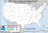
Looking at my GR, I am noticing several meso's with the storm cutting across the southern states, some wind damage and flash flooding reported in Texas and lightning all over the place. 29 flashes in 2-10 minutes. 87 in 10-30... wow... impressive. Scary part is the fact that it's nighttime, and most people probably aren't listening to their weather radios. I can't tell you how much I hate nighttime storms like this. It's a sneak attack. People are sleeping, not paying attention to the weather... except crazy people like me. This one is a hefty squall line cutting across. My prayers go out to those people in the areas being hit tonight. The good news is that it's a quick mover.
More tomorrow.
Good night!
~Dewdrop
Monday, February 12, 2007
Mesos and lightning and hail, oh my!
Subscribe to:
Post Comments (Atom)


No comments:
Post a Comment
Dew comment, please...