A crisp winter's morning. Frost kisses the grass where the dew once lay. High cirrus clouds, waftingly painted across a pale blue sky as the brilliant sun rises introducing hues of red, orange and pink.... current conditions... I thought it would be nice to tell it the way that I see it.
A little bird at the NWS told me that it looks like the severe weather threat is dwindling for Tuesday that the energy will probably be to our north, our part of the system void of deep moisture... Tim, you heart breaker, you. We will see. Of course, I will continue to watch. This is the official word: THIS MOISTURE INCREASE (dewpoints drastically increasing) MAY PLAY A SIGNIFICANT ROLE IN HOW MUCH ATMOSPHERIC DESTABILIZATION OCCURS AHEAD OF THE NEXT LOW PRESSURE SYSTEM ON TUESDAY. RECENT MODEL TRENDS...HOWEVER...HAVE BACKED OFF SUBSTANTIALLY ON THE SEVERE WX THREAT FOR TUESDAY...AS THE SFC LOW MAY NOW BE WEAKER INITIALLY AND TAKE A MORE NORTHWARD TRACK BEFORE SIGNIFICANTLY DEEPENING...WHICH MAY TAKE THE BULK OF THE SHOWERS AND ANY STORMS OFF TO OUR NORTH AS WELL. THUS...THIS MAY ALSO REQUIRE SOME DOWNWARD ADJUSTMENT TO THE POPS...BUT STILL PLAN ON KEEPING THEM IN THE CHANCE
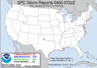
CATEGORY AT THIS TIME. They sure know how to burst my weather balloon. At least we made it into the slight risk category... see?
Have a great day!
~Dewdrop
Sunday, February 11, 2007
Sigh... north.
Subscribe to:
Post Comments (Atom)


No comments:
Post a Comment
Dew comment, please...