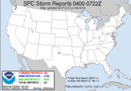
 It was amazing to me to see that there were 387 reports of hail during yesterday's event, hail as large as 4 1/4". That is some huge doggone hail... I can't imagine what it would be like to expereience that... Yes, yes, I know. We don't chase hail. As you see, there were a few tornado reports worked in there, but it appears to have mostly been a hail event... and large hail at that.
The SPC has dropped off the slight risk potential (that was over portions of NC) for today as the MCS has really lost its umph (is that spelled right?) as it tracked across the eastern plains, unloading barrels of hail. The line has definitely lost it's pizazz overnight, and we have thick cloud cover here, so I am not optimistic that we will get enough daytime heating to create anything too significant at all. At this point, all there is left to do is hope that we get at least some rain out of this system. We definitely need rain! Of course, given dry conditions, we are now under a fire weather watch, so I guess we could do without lightning (this time)... as much as I'd like to photograph it... it's just not a good thing right now for us... just rain, that's all we need is rain. We are in a 50% chance for tstms... I guess we'll just see what happens.  SHOWERS AND THUNDERSTORMS WILL MOVE ACROSS THE AREA TODAY AHEAD OF AN APPROACHING COLD FRONT. SOME OF THE STORMS THIS MORNING COULD BE STRONG WITH WIND GUSTS UP TO 45 MPH AND SMALL HAIL. THE SHOWERS AND STORMS WILL BE EXITING THE AREA TO THE SOUTH BY THIS EVENING. That squall line mentioned in the AFD at 5:00AM is looking pretty sad now, though, so I'm thinking they might back off POPS in this morning's update. It looks like there is some convergence trying to take place with the less than impressive line that remains. As heating takes place through the day (what it can given the thick cloud cover) and the afternoon MLCAPES projected to be over 1500j/kg... we could get some strong storms, so I will monitor things and post as things develop... scratch that... if things develop.
That's all I have, folks.
Toodaloo,
~Dewdrop
Wednesday, April 04, 2007
A hail of a storm!
Subscribe to:
Post Comments (Atom)


No comments:
Post a Comment
Dew comment, please...