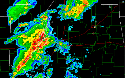
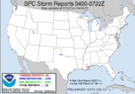
Wait a minute, is this spring or fall? Amazing. I cannot get over this forecast. The SPC has issued a Public Severe Weather Outlook for today in the central plains. (Reminds me of my chasecation where the Dewvoid was able to single-handedly destroy a high risk described as a potentially dangerous situation. Rest assured folks, I am far from the action... actually saw the stars this morning...) I chatted with my friend, David, who is getting into position in Oklahoma for this big chasetunity. While I was chatting with him this morning, he expressed concern over the storm speed. He has blogged about his feelings regarding today's storms. Check it out. Looks like a very dangerous day out there: ..POTENTIALLY SIGNIFICANT SEVERE WEATHER EPISODE POSSIBLE THIS AFTERNOON AND TONIGHT...WITH A THREAT FOR A FEW STRONG AND/OR LONG-TRACK TORNADOES...


 So... a tornado-fest in October??!! I am interested to see what happens today. I am already seeing reports of hail and some wind damage. I see that the moderate risk area has been shifted east some from yesterday's forecast. Fast mover...
This is what got me going this morning though... even though tomorrow's slight risk area has moved further away from me (which doesn't matter because I can't chase either way...), the slight risk for Friday...  includes ME (that's a reference to me, not Maine, though Maine is almost included...), even where I will be... there is even a mention of tornadoes in the discussion (granted more in Carolina Mike's neck of the woods, but...)
 SHEAR WILL ONCE AGAIN DRIVE ORGANIZED/ROTATING STORMS. ALONG WITH STRONG/DAMAGING WINDS AND HAIL...A FEW TORNADOES ARE ALSO EXPECTED -- PARTICULARLY ACROSS THE NORTHEAST WHERE BACKED/SELY BOUNDARY-LAYER FLOW IS ANTICIPATED INVOF A WARM FRONT SHIFTING NEWD ACROSS THIS REGION.
 Fortunately, Friday, my schedule at my conference is light (no dewlemma there), so I may be able to get some chasing in... how cool would that be?! I will definitely be carrying my brand-spanking-new-handy-dandy weather radio with me. I am drooling over this forecast. Even the guys are excited...
 SHOWERS AND THUNDERSTORMS WILL PRECEDE THE FRONT AND IT LOOKS LIKE WE MAY BE IN FOR SOME SEVERE WEATHER. SHEAR PROFILES ARE IMPRESSIVE AHEAD OF THE FRONT. SPC HAS VIRTUALLY THE ENTIRE ERN 1/4 OF THE NATION IN A SLIGHT RISK FOR SEVERE STORMS.
Happy secondary chase season! Isn't it lovely?
Toodaloo,
~Dewdrop
Wednesday, October 17, 2007
Public Severe Weather Outlook... in the plains...
Subscribe to:
Post Comments (Atom)


They keep pushing the Day One Moderate Risk area ever so slowly southward. Maybe they will do the same tomorrow....
ReplyDeleteI am thinking you have a chasetunity coming right up, Mike. Is that a cough I hear? ;-) Gosh I hope you're not coming down with anything... perhaps just a little SDS. Take two mesos and call me in the morning.
ReplyDeleteReally....well, I am so well known as a wx geek, that it wouldn't fool anyone. Problem is that the storms will roll through here after dark tomorrow night...
ReplyDeleteWhat? Wx geeks can't happen to get sick during a huge fall severe wx outbreak... come on, it could happen... of course, then reading your chase account on the blog the next day would be sort of telling... huh? Sounds to me, though, that you don't have to play hookie... I am NOT a fan of night events. People need to keep those NOAA weather radios on!
ReplyDelete