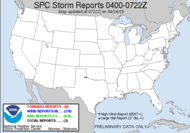
Looks like a break in the monotonous cold/warm up/cold/warm up cycle is in store for my neck of the woods. The SPC has for today dumped a slight risk for severe weather that almost includes Alabama Mike.  It looks like the bulk of it is capped and instability will be limited by some low clouds that have set up there, but tonight in the east northeast area of the slight risk, they are expecting more action with...
SLIGHTLY ELEVATED ROTATING STRUCTURES AND BOWS WILL POSE A THREAT FOR SVR HAIL...AND...ESPECIALLY TOWARD 12Z...POSSIBLY DMGG WIND.
I hate night events. Hate them.
The exciting part of the forecast arrives on Wednesday... I think that for the first time since last year, I am solidly within the slight risk area.
 Here's what they are saying...
 THE STORMS WILL SHIFT EAST DURING THE DAY (toward me)...BUT IN THEIR WAKE...WIDESPREAD CLOUDS WILL LIKELY PERSIST OVER MUCH OF WARM SECTOR (here) WHICH WILL TEND TO LIMIT INSTABILITY (can't go severe without instability). (HOWEVER...) VEERING OF THE LOW LEVEL FLOW TO WLY DURING THE DAY MAY HELP TO MIX OUT THE LOW CLOUDS FROM THE WEST JUST AHEAD OF THE FRONT (if this happens far enough ahead, enough daytime heating will occur that will offer the instability we need for some action).
 With the right convective set-up, things could very possibly explode (storm-wise) right over my head... which would actually be bad because it would be that "out of nowhere" scenario, which is one of the the worst for preparing non-weather geeks. They "didn't see it coming", so to speak.
 ACTIVITY WILL BE EMBEDDED WITHIN VERY STRONG KINEMATIC PROFILES WHICH WOULD SUPPORT AN ORGANIZED SEVERE THREAT INCLUDING SUPERCELLS AND BOWING STRUCTURES WITH ANY SURFACE BASED DEEP CONVECTION.
If not for the limiting factors and uncertainties discussed, probabilities would be much higher, as everything else supports a big event. Basically, for such an event, clouds would have to break up just ahead and moisture would have to move in... all at just the right time... but, it could happen. Here's the catch... I have SKYWARN® spotter training scheduled tomorrow. I joked with the Emergency Manager who scheduled the training that it was nice of him to schedule severe weather for our training. He joked that he just wanted to "be a hands on class". LOL! That would be awesome if we could do some on-the-job training for our spotter class! Click on the SKYWARN® logo to link to information about spotter training in your area. I think everyone stands to benefit from spotter training. Even if you don't plan to call into the National Weather Service, you will be better educated about the weather around you and, therefore, better prepared for what may come, to more adequately prepare for inclement circumstances. Did I mention that I attended "Chase School" (thanks, Alabama Mike for pointing that out), I have found and am fulfilling my destiny. When it comes to storms, you can never know too much! Thanks to all my training, I've graduated from this...
  ... to this...
Updated outlook: A CLUSTER OF STORMS COULD EVOLVE WITH THIS FORCING ACROSS NORTHERN/CENTRAL ALABAMA THROUGH CENTRAL/SOUTHERN GEORGIA DURING THE MID TO LATE AFTERNOON INTO EVENING HOURS. WHILE THE RISK FOR DAMAGING WINDS/HAIL MAY BECOME THE MOST PROMINENT SEVERE THREATS...SIZABLE CLOCKWISE CURVED LOW-LEVEL HODOGRAPHS MAY BE SUPPORTIVE OF TORNADO POTENTIAL WITH THE INITIAL MORE DISCRETE STORMS.
Holy guacamole...
Have a great day!
~Dewdrop
Tuesday, February 17, 2009
Severe weather... finally, a cure for SDS!
Subscribe to:
Post Comments (Atom)


Your kick'in with the cool hat! Watching the setup for tomorrow to see if it's worth the fuel.
ReplyDeleteI love my storm chasing hat!!!
ReplyDeleteIf you head up here, let me know! We can grab a bite or something. :O)
Tomorrow will be an interesting day.
ReplyDelete