 SKY WATCH FRIDAY time! Our hosts: Klaus Sandy Ivar Wren Louise Fishing Guy
Thanks, also,to Dot and Tom, who were instrumental in the success of this blogging event. You should definitely come fly with us!
Mammatus are pouch-like cloud structures and a rare example of clouds in sinking air. Sometimes very ominous in appearance, mammatus clouds are harmless and do not mean that a tornado is about to form; a commonly held misconception. In fact, mammatus are usually seen after the worst of a thunderstorm has passed.

In other weather news, the Atlantic Basin Hurricane Season 2009 has started with a blah... no tropical activity is detected or forecasted. 
 With nothing for us to look at in the tropics, we (the collective weather geeks) look toward the plains, where storm chasers are getting into position for an exciting round of severe weather, which will offer some tornado potential. With the great amount of money and time invested in the Vortex2 project, I know those scientists... and the producers... are eager to finally have a chance at some action. Incidentally, the tornadic risk in the plains is equivalent to the risk here, and we didn't even rate a slight risk...
  Hmmm... For tomorrow, the set-up that storm chasers everywhere have been literally drooling over is running into some limiting parameters. Apparently, instability is over expected in moderation and thermodynamics are threatening to keep a lid on things; however, where the deep shear can interact with greater instability, we might just have ourselves a ball game.
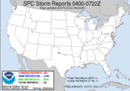
THE GREATEST THREAT FOR SUPERCELLS CAPABLE OF LARGE HAIL...DAMAGING WINDS AND PERHAPS TORNADOES WILL EXIST FROM THE VICINITY OF THE CHEYENNE RIDGE ESEWD INTO SWRN NEB/NWRN KS. FARTHER S ALONG DRYLINE... STORM INITIATION IS MUCH MORE CONDITIONAL OWING TO THE PRESENCE OF A STRONG CAP.
Our afternoon and evening thunderstorm summer-like pattern will continue as fronts collide with sea breeze. Our storm the night before last, incidentally, was never warned as severe. I bet the folks with a tree in their apartment would disagree.
ahh... but they have issued this discussion...
Yes, it says damaging wind/tornado potential is limited... but not negligible... yet, no slight risk for severe weather... no severe thunderstorm watch is expected. My guess is that someone will get in big trouble today. Protect life and property guys... with warnings... I bet you'll see local storm reports in south Georgia/north Florida, even though once again, no watch has been issued. AREAS AFFECTED...PARTS OF NRN FL/THE FL PANHANDLE INTO S CNTRL GA
CONCERNING...SEVERE POTENTIAL...WATCH UNLIKELY
THE NEED FOR A WW IS NOT CURRENTLY ANTICIPATED...BUT THE SEVERE THREAT MAY NOT BE COMPLETELY NEGLIGIBLE THROUGH THE MID/LATE AFTERNOON HOURS. WITH CAPE OF 1000-2000 J/KG ... MAY CONTRIBUTE TO LARGE ENOUGH LOW-LEVEL HODOGRAPHS FOR VIGOROUS UPDRAFTS WITH SUSTAINED ROTATION. AN ISOLATED... GENERALLY BRIEF... TORNADO IS NOT OUT OF THE QUESTION... WITH LOCALIZED DOWNBURSTS ALSO POSSIBLE. Am I the only one who sees this???
There you go: WIND DAMAGE REPORT
E TALLAHASSEE LEON FL
MINOR METAL ROOF DAMAGE TO APALACHEE ELEMENTARY SCHOOL. TIME ESTIMATED FROM RADAR.
Have a lovely day!
~Dewdrop
Thursday, June 04, 2009
I am a mammatus magnet!!!
Subscribe to:
Post Comments (Atom)


It's my weekly drop in cloud lessons to go. I keep forgetting the information I get from reading your blog. Ok this too is my fave cloud formation, now I know what it's called.
ReplyDeleteEnjoy the weekend.
a happy thursday to you...so enjoy your weekly report. we're having rain at the moment and supposedly heavy rain in the forecast for later today (central virginia).
ReplyDeletehave a wonderful weekend. and as always enjoy...
It's raining, it's pouring... but since you live where I live, you know that!
ReplyDeleteI have friends driving from here to the Florida panhandle tomorrow. Perhaps I should tell them to stay home?
Love your November shot, too!
Beautiful photo's!! Very informative.
ReplyDeleteYou are already listed on Mr. Linky! #48 right under Klaus..
ReplyDeleteWow, awesome picture and great information. I always learn so much from your posts!
ReplyDeleteAwesome shot and as always a unique informative post!
ReplyDeleteIt's rained here for days. :(
My post is here: Carletta’s Captures.
What fantastic cloud you have shown us. Thank you.
ReplyDeleteI did not know its name and would have said that the sky was boiling or roiling.
Thanks for sharing.
At least, with the way we are producing CO2 etc, you will be able to do quite a bit more of storm-chasing!
ReplyDeleteMammatus clouds certainly are lovely, especially in your top photo. I'm glad they are not dangerous but actually occur after the danger is over. ;-)
ReplyDeleteI love it that the changing skies make you so excited!
I love learning what clouds are called on your blog. Little did I know that the clouds I lose so are mammantus clouds. I am also thrilled when I spot them but didn't know the name. Your first shot is so spectacular but the more recent one is also beautiful.
ReplyDeleteThat first photo is so lovely. A wonderful capture.
ReplyDeleteAmazing clouds with a beautiful color!
ReplyDeleteGreat shot!
Gr.
P-TER
Just beautiful! I think I saw clouds like this up here recently. Nice to have the name now.
ReplyDeleteWow...your first photo is a fantastic photo!Great shot!Thank you for your very interesting posts every week!
ReplyDeleteI love the sunrise. It looks very dramatic.
ReplyDeleteFascinating post, thank you.
ReplyDeleteI'll definitely pay more attention to mammatus clouds in the future. These are lovely.
ReplyDeleteYou really have the knack for seeing those lovely clouds!
ReplyDeleteIn the first image the Mammatus clouds look like the sky is ready to fall! EEKS!
ReplyDeleteThe second photo it looks like whipped cream!YUM!
Great information with your images!
I hope I don't forget what these are called. All I can think is WOW! Those clouds are as beautiful as they are scary looking.
ReplyDeleteWow, gorgeous sky....I don't know if I've ever seen these clouds...I love all your weather info...
ReplyDeleteExcellent post. Very informative.
ReplyDeleteBeautiful indeed.
ReplyDeleteWowser! Yes, I remember that this is your fave cloud structure. Lucky you to have captured it then! When I've seen them, it's rare and has been from inside a car or our house, after a T-storm has passed.
ReplyDeleteOh my, I just read you saw your 3rd patch in only 5 days! Lucky you.
Those are also rich colours you captured in this formation. I hope it was a routine dr visit and you're feeling fine.
That first photo is magnificent...
ReplyDeleteVery informative post...I need to check back more often !!