 SKY WATCH FRIDAY time! Thanks to Dot and Tom, never forgotten founders of this great event. Come on, come fly with us!
Thanks to hosts: Klaus Sandy Sylvia Wren Louise Fishing Guy
As I was saying, hurricane season is not over till it's over. We've now got a 1,2,3 line up of tropical action, all siblings off the coast of Africa barreling across the Atlantic Ocean. 
 Hurricane Danielle, now, once again a category 2 hurricane after some interaction with dry air has rebounded to be quite a storm, now showing indications of eyewall development. She is actually forecast to become a major hurricane, but I would expect her to become a fish storm, staying out to sea. Unfortunately, her little brother, Tropical Storm Earl, hot on her heels, is also forecast to get close to major hurricane strength, but he is expected to take a more southern track, which makes him a contender for some US action. I can almost hear the headlines... "Goodbye Earl!" "Earl's Gotta Die!" What a storm to impact the US... sigh. The third system, still just is wave (an impressive wave!), is hot off the coast of Africa, but some are already talking Fiona...
 It looks pretty impressive to me!
Tuesday was a crazy day for me. I had a wonderful afternoon excursion over lunch with my wonderful groom, and we went and explored in the jeep some! It was yet another great adventure for the two of us. We saw some really interesting things along the way including crews working to break down some rail cars that had de-railed. 
 I had never seen that before, so it was really neat.
  Then, I went to the doctor’s and got some icky news about a test he wants to run. I’ll survive it, but I am not excited about it. As I was leaving from Wally World, someone backed into my van… bumped in the side door. It’s only cosmetic… no one was injured and the mechanics of the door were unaffected, but seriously… what a day!
  I had a great meeting at church after that, but then, when I went to pick up Mini-Dew from practice, the sky had a hint of mammatus clouds popping. Of course, I stuck around out there, shooting a few pics until they were no longer visible. The pretty much fizzled out, just in time for sunset. Doesn’t that figure? I went in to get Mini-Dew and when I came out… KAPLOW!
 ... and then it followed me home!!! What a spectacular demonstration of God's awesomeness. He has a beautiful way of encouraging me, in the perfect way. I love my little love letters from God! Wasn’t it sensational?!
Have a mammatus-ful day!
~Dewdrop
Thursday, August 26, 2010
The Majesty of His Power


Thursday, March 04, 2010
Another love note from God...
SKY WATCH FRIDAY time! Welcome all sky fans!!! I truly appreciate your visit and comments. I might not have time to respond to you, but I will try my best to visit!!!
Our hosts: Klaus Sandy Sylvia Wren Louise Fishing Guy
Thanks, also,to Dot and Tom, who were instrumental in the success of this blogging event. You should definitely come fly with us! With severe weather season just around the corner... I am reminiscing about some of my more enjoyable and photographable storm encounters. The pictures below capture an exciting day back in June 2008. It started with wonderful towers going up all over the place. The clouds were barely moving, except climbing up into the sky. We had a brilliant rainbow for a time, but then, there was this... a wonderfully sunset-lit tower rising to my southeast, catching the light brilliantly and radiating with a glow of pink and salmon.  I stood in awe of the beauty for some time before I noticed just above my head was an amazing patch of mammatus (my FAVORITE!!), which were also carrying the colors of the glorious sunset. After being drawn to that for some time... and taking a bunch of pictures, I went in to eat.
 After dinner, I came out to discover that this beautiful tower of splendor was still there, but now it was firing every few seconds with a magnificent lavender electrical storm... all seemingly contained within the confines of this beautiful structure.
 Speak Lord, your servant is listening.
~Dewdrop
Thursday, October 15, 2009
He speaks to me through the sky
SKY WATCH FRIDAY time! Welcome all sky fans!!! I might not have time to respond to you, but I will try my best to visit!!!
Our hosts: Klaus Sandy Sylvia Wren Louise Fishing Guy
Thanks, also,to Dot and Tom, who were instrumental in the success of this blogging event. You should definitely come fly with us!

God romances us in the sunsets and falling stars; moonlight on lakes and cricket symphonies; warm wind, swaying trees, lush gardens and fierce devotion, as if scripted to your heart. God delights in revealing himself to those who will seek him with all their hearts.
It's no mystery that God reaches me through the sky. I am captivated by the shows God seems to put on... just for me. He knows the song of my heart, and He plays it for me with a breathtaking sunrise, an unforgettable sunset, a brilliant double rainbow, an astonishing solar 22° halo (complete with upper tangent arc), beaming crepuscular rays, an exciting dust devil, a dancing funnel cloud, or in one quite memorable case, an unbelievable field of mammatus clouds perfectly timed with sunrise.
Captivating, John and Stasi Eldredge
When I stepped outside and was greeted with a complete sky full of mammatus clouds (my absolute favorite, but at that point never realized) on that incredibly special November morning, it was truly as if God personally reached down, gently took my hands and said... "Hey there, my precious daughter, take a look at what I made especially for you." It was better than the finest work of art I had ever seen. I was driven to my knees, awestruck at the splendor of His precious gift. That gift from our great and glorious God spoke directly to the deeper part of my heart, it danced on my soul. Through that glorious experience and encounter with the Holy Spirit, I knew, with no uncertainty, that God, our great and magnificent God, loves me. I am precious to Him.
How does He speak to you?
Cooler weather, mudslides in California, another potential typhoon headed for the northern Philippines. "Don't tell God how big your storm is; tell the storm how big your God is."
Have a blessed day! May all your skies be mammatus filled...
~Dewdrop
Thursday, June 04, 2009
I am a mammatus magnet!!!
SKY WATCH FRIDAY time! Our hosts: Klaus Sandy Ivar Wren Louise Fishing Guy
Thanks, also,to Dot and Tom, who were instrumental in the success of this blogging event. You should definitely come fly with us! Well, it happened again! That's 4 times in one year... I was leaving the doctor's office yesterday, and I looked up to see a small patch of mammatus clouds! Mammatus clouds, you know if you've been around me, are my absolute FAVORITE cloud structure! OK, so the pic above is not from yesterday's encounter. I was truly blessed to experience that amazing sky full of mammatus sunrise last November, but I did look up to see my 3rd patch of mammatus in 5 days!!!
 Mammatus are pouch-like cloud structures and a rare example of clouds in sinking air. Sometimes very ominous in appearance, mammatus clouds are harmless and do not mean that a tornado is about to form; a commonly held misconception. In fact, mammatus are usually seen after the worst of a thunderstorm has passed.
 So, this is what I actually saw yesterday. No, you're right, it's not nearly as impressive as my wonderful November encounter, nor is it as impressive even as the Friday afternoon show... or the Friday sunset show... but it was mammatus, so I am NOT complaining. My wonderful groom called me a mammatus-magnet. Hey, I'll take that title, gladly.
In other weather news, the Atlantic Basin Hurricane Season 2009 has started with a blah... no tropical activity is detected or forecasted. 
 With nothing for us to look at in the tropics, we (the collective weather geeks) look toward the plains, where storm chasers are getting into position for an exciting round of severe weather, which will offer some tornado potential. With the great amount of money and time invested in the Vortex2 project, I know those scientists... and the producers... are eager to finally have a chance at some action. Incidentally, the tornadic risk in the plains is equivalent to the risk here, and we didn't even rate a slight risk...
  Hmmm... For tomorrow, the set-up that storm chasers everywhere have been literally drooling over is running into some limiting parameters. Apparently, instability is over expected in moderation and thermodynamics are threatening to keep a lid on things; however, where the deep shear can interact with greater instability, we might just have ourselves a ball game.
THE GREATEST THREAT FOR SUPERCELLS CAPABLE OF LARGE HAIL...DAMAGING WINDS AND PERHAPS TORNADOES WILL EXIST FROM THE VICINITY OF THE CHEYENNE RIDGE ESEWD INTO SWRN NEB/NWRN KS. FARTHER S ALONG DRYLINE... STORM INITIATION IS MUCH MORE CONDITIONAL OWING TO THE PRESENCE OF A STRONG CAP.
Our afternoon and evening thunderstorm summer-like pattern will continue as fronts collide with sea breeze. Our storm the night before last, incidentally, was never warned as severe. I bet the folks with a tree in their apartment would disagree.
ahh... but they have issued this discussion...
Yes, it says damaging wind/tornado potential is limited... but not negligible... yet, no slight risk for severe weather... no severe thunderstorm watch is expected. My guess is that someone will get in big trouble today. Protect life and property guys... with warnings... I bet you'll see local storm reports in south Georgia/north Florida, even though once again, no watch has been issued. AREAS AFFECTED...PARTS OF NRN FL/THE FL PANHANDLE INTO S CNTRL GA
CONCERNING...SEVERE POTENTIAL...WATCH UNLIKELY
THE NEED FOR A WW IS NOT CURRENTLY ANTICIPATED...BUT THE SEVERE THREAT MAY NOT BE COMPLETELY NEGLIGIBLE THROUGH THE MID/LATE AFTERNOON HOURS. WITH CAPE OF 1000-2000 J/KG ... MAY CONTRIBUTE TO LARGE ENOUGH LOW-LEVEL HODOGRAPHS FOR VIGOROUS UPDRAFTS WITH SUSTAINED ROTATION. AN ISOLATED... GENERALLY BRIEF... TORNADO IS NOT OUT OF THE QUESTION... WITH LOCALIZED DOWNBURSTS ALSO POSSIBLE. Am I the only one who sees this???
There you go: WIND DAMAGE REPORT
E TALLAHASSEE LEON FL
MINOR METAL ROOF DAMAGE TO APALACHEE ELEMENTARY SCHOOL. TIME ESTIMATED FROM RADAR.
Have a lovely day!
~Dewdrop
Friday, May 29, 2009
Ma ma ma more mammatus!
So, after I enjoyed the thunderstorm and post pics of what I thought was an amazing sky, I walked out of the office a little later than I had planned because I wanted to get that posted... and this is what I was blessed with:


 Another spectacular mammatus show. I saw my first mammatus show last November, and it was an incredibly powerful and emotional experience. This one wasn't as spectacular as the first, but it grew into the sky, getting more and more defined as it moved in from the south southwest. It was gorgeous in that grey stormy sky, and I was once again mesmerized by God's awesomeness!
 Revelation Song
I must have stayed there 20 minutes shooting the amazing mammatus sky...
Holy, holy, holy is the Lord God Almighty
Who was and is and is to come
With all creation I sing praise to the King of kings
You are my everything, and I will adore You
Clothed in rainbows of living color
Flashes of lightning, rolls of thunder
Blessing and honor, strength and glory and power be
To You, the only wise King
Filled with wonder, awestruck wonder
At the mention of Your Name
Jesus, Your Name is power, breath and living water, such a marvelous mystery
Holy, holy, holy is the Lord God Almighty
Who was and is and is to come
With all creation I sing praise to the King of kings
You are my everything, and I will adore You
The day progressed and we ran to Wally World to pick up a few things, but upon leaving, we were graced with a multi-dimensional sky, with a palette of colors and depths of clouds. It was phenomenal. No matter which direction we looked, the view of the sky was absolutely spectacular.  Then, a quick look to my obscured west suggested that we might get an amazing show with what was left of the sunset, so I asked my wonderful groom to drive around into a better position to see the remnants... you're not going to believe this, but...
 ... the mammatus made an encore appearance for sunset!!!
How great is our God?
~Dew
Thursday, January 29, 2009
More Mammatus...
Hey there! Thanks for stopping by for this week's installment of SKY WATCH FRIDAY! Please visit Klaus, Sandy, Ivar, Wren, Louise and Fishing Guy's SKY WATCH BLOG to participate in Sky Watch Fridays, which is WELL WORTH YOUR WHILE!! Thanks to Dot, the momma of this fabulous blogging event, and to my dear friend, Tom, who brought it to full blossom. I, personally, love visiting the skies all over the world!!! You should definitely come fly with us! I have decided to post another picture from my November 14, 2008, Mammatus Spectacle!
 Mammatus (also known as mammatocumulus, meaning "bumpy clouds") is a meteorological term applied to a cellular pattern of pouches hanging underneath the base of a cloud.
This photograph demonstrates the magnitude of this splendid experience. The pic that I posted last week showed the view behind my house, facing due east toward the rising sun. This is the view in front of my house at about the same time, facing west southwest. The entire sky was covered in this amazing, miraculous, glorious phenomena for hours that day. In fact, there are what they looked like an hour later when I left for work... spectacular!
~Wikipedia
Glory and praise to our God,
who alone gives light to our days.
Many are the blessings He bears
to those who trust in his ways.
~Dan Shutte, "Glory and Praise to Our God"
Unfortunately, the death toll from the horrendous winter ice storm has risen to 23, and with power still out for hundreds of thousands of people and a fear that the status won't change soon, the likelihood that the number may rise is frightening. Inches of ice piled up on everything is created traffic nightmares, tree breakage, and power line breakage and failure. It's a nightmare to many. May God bless them. Unfortunately here, today, the temperatures have capped out in the 50's... I can't really complain though...
I never did talk about the US Airways Flight 1549 that made an emergency landing on January 15th in the Hudson River. That day was in the middle of that horrible Arctic blast, where New York saw some of the coldest temps of the season. The water of the Hudson at the time of the crash was in the high 30's, and the air temperature was in the 20's! Despite that, all 155 passengers and crew were safely evacuated within 5 minutes of the crash, which was an amazing landing by the veteran pilot and co-pilot. Well, a cartoonist Rex Babin drew this image to capture the "miracle on Hudson River": [Rex Babin]
WOW! Thanks to my dear friend for sharing that.
Have a GLORIOUS day!
~Dewdrop
Thursday, November 20, 2008
I'm dreaming of a white... Thanksgiving...?!
 Howdy Dew, folks!!! Once again, it's time for a Sky Watch "Friday" post! Please visit Klaus, Sandy, Ivar, Wren, Louise and Fishing Guy's SKY WATCH BLOG to participate in Sky Watch Fridays, which I HIGHLY RECOMMEND!! Dot, the mother of this fabulous blogging event, was really onto something when she brainstormed this baby!!! And last, but certainly not least to the "retired" Tom, the one who brought the concept to full bloom. It is so fascinating to see skies from all over the world!!! You should definitely climb aboard the SWF Express! For this week's Sky Watch post, I am going to share one of the mammatus cloud shots that I took last week when God blessed me with the amazing spectacle.
 mammatus clouds are my all time favorite cloud structure!
 Mammatus (also known as mammatocumulus, meaning "bumpy clouds") is a meteorological term applied to a cellular pattern of pouches hanging underneath the base of a cloud. The name "mammatus" is derived from the Latin mamma (breast), due to the resemblance between the shape of these clouds and human female breasts. Mammatus are most often associated with the anvil cloud that extends from a cumulonimbus, but may also be found under altocumulus, altostratus, stratocumulus, and cirrus clouds, as well as contrails and volcanic ash clouds. When occurring in cumulonimbus, mammatus are often indicative of a particularly strong storm or maybe even a tornadic storm.
I love their amazing uniqueness! The lobe-shaped under belly of the clouds offer an amazingly distinct ceiling to the sky, and I was blessed to have a full sky of them during SUNRISE! God truly is an AMAZING artist with PERFECT timing!
Aside from that, the big story is the unseasonably COLD weather that has embedded itself in the southeast! The mercury has dipped. The temperatures have plunged, and the Dewdrop is NOT HAPPY about it. Due to my geographical misplacement, most of the severe weather completely misses me or presents itself in nasty heavily precipitated squall line events. The advantage of this unpleasant geographic placement is supposed to be the MILD fall weather. Where is that?! Where is the beautiful seasonable south Georgia fall weather that I have grown to know and love and really appreciate. I'll tell you where it is, it's in the Texas panhandle with Steve Miller, you doggone autumn hog! We are on day 3 of freezing temps, with low and high temperatures dipping down way below the average for this time of year!  It feels more like our hardest part of winter, what we might expect in January or February, but this is certainly not our typical November weather. Though temperatures are expected to tease us today by climbing to near 70's, the bottom is about to fall out as the clipper system breezing by to our north bears down on a low pressure system with a trailing cold front, which will bring about another round of Jack Frost nipping at our noses. Gosh, I hate it when the whole map is blue and purple. I hope it doesn't s#@w! Is it spring yet?
Have a lovely day... try to stay warm.
~Dewdrop
Friday, November 14, 2008
MA, MA, MA, MY MAMMATUS!!!!
 I don't even know where to begin talking about today... I have been blown away by God's awesomeness! I think I've mentioned several times that my favorite cloud type is mammatus... well, I had only ever seen them locally and in person about 3 or 4 times... prior to today, but I had seen other's captures of those amazing clouds, and I absolutely LOVE them. Yesterday, while I was trying to find a suitable SWF picture of the sky to post, I thought... I sure would love to have some great mammatus pictures to share (seriously, I thought that, with a frustrated edge). You see, they aren't all that common here. I've seen them a few times, fairly randomly and much appreciated them, but I have never had an opportunity to capture how truly beautiful and magnificent they can be... until today. Sometimes, the turnaround time on God's blessings blow me away. This morning, as I was walking outside to wait for Mini-Dew's bus, I caught a glimpse of the edge (therefore hadn't even seen the splendor behind me of a mammatus field. Me, being who I am, ran back into the house for my camera. When I turned around, I was just about knocked off my feet with what I saw, a mass of mammatus clouds filled my sky! I mean, well defined mammatus plastered the sky! Better yet, it was just before sunrise, so God was about to show His amazing glory! (I am tearing up just remembering how wonderful it was...) I have cried all morning, praise God. God is awesome! Without further a-dew, allow me to just share with you, the show (unaltered photos except sizing, all God's work)...


 How awesome is He?! I sat and watched the sky this morning for half an hour as the colors from the rising sun did their work against the mamma textured sky, all the while feeling God's unhindered, unbroken, unconditional love for me. This sky was a vision of hope, peace and love. What a precious gift from God that it was! The pictures reenforce my memory, but you really had to be there to get the full affect of this amazing spiritual encounter.
4:45PM Update: James Spann posted my pics!! Check it out!! He also sent me an email telling me they are "really good"! :O) Thanks, Mike!
Now... I am going to look at things a little more scientifically and tell you what it means weather-wise...Mammatus (also known as mammatocumulus, meaning "bumpy clouds") is a meteorological term applied to a cellular pattern of pouches hanging underneath the base of a cloud. The name "mammatus" is derived from the Latin mamma (breast), due to the resemblance between the shape of these clouds and human female breasts.
Check out the link there for lots of hypothesized formation mechanisms.
Mammatus are most often associated with the anvil cloud that extends from a cumulonimbus, but may also be found under altocumulus, altostratus, stratocumulus, and cirrus clouds, as well as contrails and volcanic ash clouds. When occurring in cumulonimbus, mammatus are often indicative of a particularly strong storm or maybe even a tornadic storm. These tend to form more often during warm months and over the midwest and eastern portions of the United States (it's in the 70's today).
Mammatus may appear as smooth, ragged or lumpy lobes and may be opaque or semitransparent. Because mammatus occur as a grouping of lobes, the way they clump together can vary from an isolated cluster to a field of mamma that spread over hundreds of kilometers to being organized along a line, and may be composed of unequal- or similarly-sized lobes. A lobe can last an average of 10 minutes, but a whole cluster of mamma can range from 15 minutes to a few hours (ours lasted at least 2 hours this morning!!!). Their composition is usually mostly ice, but can be a mixture of ice and liquid water or almost entirely liquid water.
~source
Here's the kicker... it's been months since we have seen a slight risk, and lo and behold... 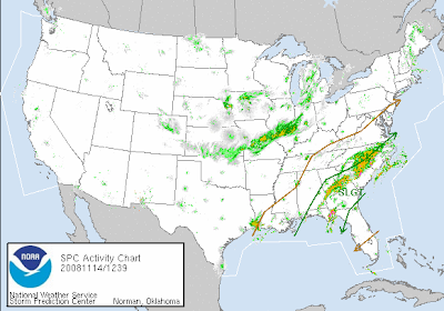 SLIGHT RISK, right slap dab on top of me! With this wording...
 SOUTHERN/CENTRAL GA TODAY... MODEL FORECAST SOUNDINGS SUGGEST THAT DEEP LAYER VERTICAL SHEAR IS FAVORABLE FOR SUPERCELLS... WITH SUFFICIENT LOW LEVEL SHEAR FOR ISOLATED TORNADOES ALONG PRE-EXISTING BOUNDARIES THIS AFTERNOON.
I've got a feeling, today is the day. If we get a break in the stratus cloud deck that has (since the mammatus) moved in, which would allow for some daytime heating to break through and destabilize things, it might be showtime.
Aside from all that... I have been asked to publish for the Examiner, as a paid author. I am the official Georgia Weather Examiner. Check me out at this link. Go me! please check out my link!
4:30PM Update from AL Mike... This just in from Spann...The air is rather unstable over South Alabama and the southern two-thirds of Georgia; surface based CAPE values are near 2,500 j/kg (great googaly moogaly!!!)near the Alabama/Florida border around Geneva with surface temperatures hovering around 80 degrees. Strong to severe thunderstorms are possible across the region during the next 6 to 8 hours, and SPC indicates they might pull the trigger on a severe thunderstorm watch for much of Central and South Georgia.
Stay tuned!
~Dewdrop





















