 SKY WATCH FRIDAY time! Welcome all sky fans!!! I might not have time to respond to you, but I will try my best to visit!!!
Our hosts: Klaus Sandy Sylvia Wren Louise Fishing Guy
Thanks, also,to Dot and Tom, who were instrumental in the success of this blogging event. You should definitely come fly with us!
Oh boy, have I got a treat for you! I actually shot it this morning. It was such a joy to catch a glimpse once again of yet another fairly uncommon phenomena. I have researched cloud iridescence in the past, but I have never witnessed it first-hand, that I can recall. Cloud iridescence occurs when light (generally it occurs in the clouds close to the sun's location in the sky) hits small individual water droplets or even small ice crystals and the iridescence (like a smudged rainbow in the clouds)is a diffraction phenomenon, where light is apparently bending around the small water droplets and spreading out its waves past small openings, not to be confused with the refraction phenomenon, where light's direction is changed due to a change in velocity, such as when light encounters a large impenetrable area, creating an almost angled reflection. Such refraction occurs when light hits larger quantities of water and will tend to generate a halo, arcs or perhaps a rainbow. Those are different effects. Diffraction is almost a smudging of light, where refraction displaces its original path.

Cloud iridescence or irisation is the occurrence of colors in a cloud not dissimilar to those seen in oil films on puddles. It is fairly uncommon phenomena and is usually observed in altocumulus, cirrocumulus and lenticular clouds but very rarely in Cirrus clouds.
In my case, the cloud iridescence occurred in cirrocumulus clouds. To read more about cloud iridescence, feel free to check out this link. These little love letters from God thrill my heart. In weather, a storm system that dropped feet of snow (I hate that word) in some places in and around Colorado, has now created a severe weather scenario in the plains. The front has turned into a squall line of severe weather for some, as it races across the country as a virtual wall of wind and rain.
Have a beautiful day!
~Dewdrop
Thursday, October 29, 2009
Iridescence in the sky
Wednesday, October 28, 2009
Updated Halloween forecast
 With the snowstorm in the midwest and the battle between summer and winter ensuing, we are expecting some severe weather in the plains. Of course, as it makes its way toward the Dewvoid (see post below), it should diminish. What does that mean for Halloween??? Well, this is the precipitation forecast for Halloween, as it stands...
 So, the northeast... the Rockies... and Dewville. Of course, rain on Halloween night, while we have all those kids over, trapped inside my house, or riding on wet hay... figures. Some are surprised to learn that I am not a big fan of rain. Rain is good in moderation, occasionally falling to ward off drought, but as a general rule, rain inhibits instability which is necessary for thunderstorms and severe weather, which is really what interests me. It's no fun chasing rain. 1. You get wet. 2. Your gear gets wet. 3. The pictures aren't good at all. So, you see, though I am a storm chaser, and I am extremely passionate about weather, I am not a big fan of the wet stuff, and before you ask, I don't even generally spell the word s#@w. I only used it as a part of a better compound word.
So, you see the green... where it is green on the map, the current expectation is that trick or treating could be washed up.
Have a blessed day!
~Dewdrop
Tuesday, October 27, 2009
The Dewvoid strikes again...
Well, the Dewvoid appears to be prevailing. As I mentioned, our solid stratus deck has done its work to prevent the necessary instability to get things rolling in these parts. In these parts, we refer to that effect as the DEWVOID. The DEWVOID is loosely defined as the apparent weatherlessness that chases storm chaser, Dewdrop. The DEWVOID effect can single handedly kill a high risk PDS threat and render it nothingness.
Check out the wording in the mesoscale discussion just issued for my neck of the woods, and allow me to translate... Feel free to click on the image above if you don't believe me.
MAIN CONVECTIVE BAND CONTINUES MOVING EWD ACROSS THE ERN GULF/SERN CONUS (toward the area of apparent Dewvoidness)...WITH SOMEWHAT STRONGER/MORE CELLULAR CONVECTION FROM SWRN GA SWD (in other words, it is strong to severe away from here). EVEN ACROSS THIS REGION (the Dewvoid region) HOWEVER... WEAK INSTABILITY (what did I tell you?)-- AS INDICATED BY THE LACK OF INLAND LIGHTNING ATTM (and the presence of Dewdrop)-- CONTINUES TO
Ugh.
HINDER THE DEVELOPMENT OF ISOLATED/STRONGER STORMS. LIKEWISE...A DECREASE IN INTENSITY WITHIN THE ONGOING CONVECTION HAS BEEN NOTED OVER THE PAST COUPLE OF HOURS (as the system approaches Dew -- gasp, what a surprise!).
WHILE SHEAR PROFILES REMAIN FAVORABLE FOR ROTATION WITHIN ANY SUSTAINED/STRONGER UPDRAFT (as if!)... A CONTINUED DECREASE IN CONVECTIVE INTENSITY IS FORECAST GIVEN THE LACK OF INSTABILITY (Dewvoid effect expected)... AND GIVEN THE STRONGER LARGE-SCALE FORCING CONTINUING ITS NEWD SHIFT AWAY FROM THIS REGION (The Dewvoid will actually be driving the storm away!). WHILE AN ISOLATED/BRIEF TORNADO REMAINS POSSIBLE (HA!) OVER THE NEXT COUPLE OF HOURS...THREAT SHOULD CONTINUE TO SLOWLY DIMINISH THIS AFTERNOON (as it continues to approach Dew).
~Dew
Tornado watch in the south
Well, there I was about to give a more current (since yesterday) update about Halloween weather, when Rick mentions tornado watch... WHAT?! TORNADO WATCH!!! HERE?! NOW?! Yes.  Yes, folks, until 6PM for a small area of the southeast, including my very own county. Remember that a tornado watch means that conditions favor the development of tornadoes, and you should be mindful of rapidly changing conditions.
DISCUSSION...TSTMS EXPECTED TO CONTINUE DEVELOPING IN MOIST...STRONGLY-SHEARED LOW LVL WAA ZONE ALONG CONFLUENCE AXIS OVER THE NERN GULF OF MEXICO AS REGION IS GLANCED BY RED RVR VLY SHORTWAVE IMPULSE. POTENTIAL WILL EXIST FOR SCTD STORMS WITH LOW LVL ROTATION AND POSSIBLE TORNADOES AS W/E FRONT NOW ALONG THE CST OF THE FL PANHANDLE MOVES SLOWLY NWD.
Be ready to seek shelter. At this time, we have a solid deck of status clouds and a persistent drizzle, which will prevent necessary heating for instability, but if we get a break in this cloud deck... and it's timed enough before the arrival of this front, we could have an explosion of weather. You see that currently, the slight risk for severe weather exists right on top of me. Feel free to click on the below graphic for a current look. The tornado potential stands at 5% for my area. That means that this first wave is expected to clear up and the big one behind it could drop a few naders. Remember, the watch continues until 6PM, so do not let your guard down, especially once it clears here in the south. Below is a map of the tornadic threat.
 Have a safe day! I'll have one eye on weather.
~Dewdrop
Monday, October 26, 2009
Halloween weather
 Hope everyone had a great weekend! I know ours was nice and relaxing, catching up on some missed shows... enjoying the great fall weather we had and still have. Things are definitely falling into that fall weather pattern, with cold fronts blasting in wind and rain (and potential for severity), the crisp cool air and gentle breeze follows. As that fades, and temperatures start to rise again, the scene sets itself up for another round, as another cold front presses in... That cycle generally repeats until winter takes hold. Our fall is a series of battles between summer and winter. Fortunately, down in my neck of the woods, being cold weather adverse, winter never really wins the war down here. We might have a few downright miserable days, but it rarely sticks.
Now, the big question is probably people wondering about Saturday... Well, it's still a little far out, but there is another one of those blasted cold fronts creeping along the south leading up to that.
 This covers Thursday (Day 4) and Friday (Day 5), and places a chance for severe weather in the indicated areas. Day 6, Saturday will be the leftovers of that system and depending on the speed of the system, we will know where it will be and when. It looks like it will eject hard to the north, leaving just an early trail of precipitation for the south, but it looks like some could have a very wet time of Trick or Treating.
  In light of our planned festivities, I am hopeful that we will escape the worst of it.
Have a great day!
~Dewdrop
Thursday, October 22, 2009
We want the weather!!!
SKY WATCH FRIDAY time! Welcome all sky fans!!! I might not have time to respond to you, but I will try my best to visit!!!
Our hosts: Klaus Sandy Sylvia Wren Louise Fishing Guy
Thanks, also,to Dot and Tom, who were instrumental in the success of this blogging event. You should definitely come fly with us! In honor of our secondary severe weather season, which occurs in fall here, I have posted one of the better and more ominous looking shelf clouds that I have experienced here. I was leaving work one day, when I spotted this very low to the ground cloud structure approaching my location. This is a shelf cloud, and generally their bark is worse than their bite, as was the case with this one. They can carry with them downburst potential and outflow winds which could actually result in straight line wind damage, but they are not typically an area where we would see tornadoes, gustnadoes, yes, tornadoes... no. They do, however, warn of the potential danger. If you see such a feature, you should take it as your warning to seek shelter indoors. Wind, rain, lightning, hail and tornadoes could follow.
Locally, we have already had one round of severe weather this season, but as the season wears on, and the battle between summer and winter becomes more intense, we should see more.  Today, the slight risk for severe weather exists in Louisiana and Mississippi with a tornado watch already presenting itself covering most of Louisiana (feel free to click on the graphic here for updates). It should mostly only amount to some thunderstorms by the time it makes its way over here. Interestingly, the storm working its way across the southern states are, in part, the remnants of once category 5 Hurricane Rick from the eastern Pacific. Tropical Storm Rick made landfall in Mexico and traveled across Texas dropping buckets of rain on the now quite water-logged areas.
Of course, moisture feed off the Gulf of Mexico has now merged with the now remnant low to make a severe weather event in the south. Incidentally, there are two areas being watched in the Atlantic basin with a low likelihood of development. Hurricane season is not over yet, folks.
Aside from all that, I would like to briefly get on my soapbox (once again) regarding the ridiculousness of the Weather Channel (TWC). TWC has decided that they need to break from their dying traditional of simply showing (GASP!) the weather, and have decided that for some reason their viewing are tuning in for weather movies. They have decided to start airing Friday night movies.... link. I am outraged by the continued effort to turn TWC into "just another stupid station", because at this time it is one of the only channels I watch. I like the quick look at what's going on with the "Local on the 8's". I like the weather updates round the clock. I love the "Tropical Updates". I enjoy their radar, their tornado warning notices... the stories about weather related events, impact and recovery... but their increasing "need" to expand the length of programming with their "When Weather Changed History" or "Storm Stories"... or worse yet, the preposterous "Wake Up With Al" morning TALK SHOW!!! What are these programmers thinking?! Weather people! We are tuning in for weather, and if that goes away, SO DO WE! Get your heads out of the money tree and back into the clouds where they belong!
Off soapbox,
~Dewdrop
Wednesday, October 21, 2009
More SKYWARN® Spotter training
 Yesterday, I did something very exciting. I participated in the first National Weather Service - Tallahassee online spotter training session. Yes, I realize that I have been through online training, and I have sat through 6 or 7 live spotter training classes. I have covered both beginner and advanced level training, inside and out. I have traveled near and far, chasing an unquenchable thirst for more knowledge. This was a live webinar though. I didn't have to go anywhere.
  Please click on the link above to see about becoming a SKYWARN® Spotter. I strongly encourage it, even if you're not as coo-coo for weather as I am. As Mini-Dew has told me time and time again, I'm "a nerd". I know that. I accept that. I could probably teach the spotter classes at this point, but I love sitting through the classes. I have earned yet another certificate of training as a SKYWARN® Spotter, this time in my new name, by taking a test at this link. Fortunately, I knew better than to say that the most common storm type in our area is the Common Southeastern Frog-strangler... though they do occur... LOL!! Laugh as you may, I always walk away from those training sessions with new information, and this one was no different. I learned more about RFD (rear flank downdraft) and the implications of possible tornadic activity, and I had only a limited knowledge of those before. I learned about the implications of pileus clouds, which I actually could have figured out, but hadn't thought about it.
 Pileus clouds are the fibrous lid over cumulus congestus clouds caused by heavy upper level shear. I don't have any great pics of pileus clouds, but I hope to soon. This is more of a dissipating storm.
I found the wind rating chart to be an effective resource tool, and it was especially jazzed up with the capture by my friend, Mike Umscheid.  Then there was the other pic shared that was taken by one of my other friends to the wall cloud section. I'm not sure which Steve Miller captured this shot, but it was cool to see it taken by one of my friends.
 I really need to start being more assertive in submitting my own pics to the NWS for possible inclusion in their training slideshow. They say they want my stuff.
  I should start sending my stuff in, huh? Then, I could get all excited when I see my stuff...
Have a spotterific day!
~Dewdrop
Tuesday, October 20, 2009
Before the storm and the rest of the weekend!
So, in my last post, I shared with you, some of the strong to severe storm action we experienced in my region on Thursday night/Friday morning. One of the members of our regional storm chasing team, the Southern Weather Brigade, Mike, deployed into the area, trying to capture lightning and anything else that might "spin up" along the way. Some mesocyclonical spin-ups were being reported, and he actually deployed into a tornado warned area. In the morning (dark and early), at 5am, we were graced with a severe thunderstorm warning of our own, which didn't blare on my weather radio???, but it did come through on our phones with the county CodeRED weather warning system. I immediately jumped into action checking GR radar to see if any rotation was noted. Nope, but the size of the cell was amazing. HUGE! Well, I am telling you all this to show you what it was like before the storms broke loose in the south that night. We had a break in the cloud cover of the day, which made for an amazingly striking sunset, which I had no choice but to capture.

 Aside from that, we had a lovely albeit COLD weekend! On Saturday, we woke up and headed out to the pumpkin patch, where we strolled through piles of pumpkins, trying to find one that suited us perfectly. The "kids" (all of them!!) had a great time, teeth chattering and all.

 After that, we headed out to the local amusement park to enjoy a fun family day of riding rides and all that goes with it. Oops... revenue hounds might want to fix that...
  We especially had fun in the Lorikeet feeding exhibit, where the kids had lorikeets all over them.


 When our fingers were sufficiently numb, we returned home for some pumpkin carving and thawing out. It was great fun carving into our chosen pumpkins and gumpkins and seeing where our imaginations carried us... We had a great time exploring our creativity and really letting the juices flow...
  ... and the pumpkin seeds and the guts... Mini-Dew even took to cloning...
 We had so much fun!!! Introducing... Dew's odd pumpkin family:
  It was a truly great weekend.
The high pressure system, which has firmly planted itself over the southeastern US has offered plentiful clear skies and cold, windy weather. It is nice to finally have a season change, but did we have to skip fall???
Stay warm!
~Dewdrop
Thursday, October 15, 2009
Action in South Georgia
 Meso Mike has deployed to the red dot. We just got the EAS for the rapidly approaching cell. There is still some opportunity for blow up with continued gulf feed interaction with the front.
0715 PM CDT THU OCT 15 2009
Mike is going to the southeast to try to get ahead of it.
AREAS AFFECTED...SRN GA
CONCERNING...SEVERE POTENTIAL...WATCH UNLIKELY
THE THREAT FOR ISOLATED SEVERE STORMS CAPABLE OF LOCALLY STRONG WIND GUSTS AND PERHAPS A BRIEF TORNADO IS EXPECTED TO CONTINUE ACROSS PARTS OF SRN GA TONIGHT. A WW IS NOT ANTICIPATED.
Significant weather alert...
1014 PM EDT THU OCT 15 2009
...A SIGNIFICANT WEATHER ALERT IS IN EFFECT FOR BERRIEN...COOK...~Dew
LANIER AND LOWNDES COUNTIES...
* UNTIL 1100 PM EDT
AT 1013 PM EDT...NATIONAL WEATHER SERVICE DOPPLER RADAR INDICATED A
STRONG THUNDERSTORM NEAR RAY CITY...OR 5 MILES SOUTHEAST OF
NASHVILLE...MOVING EAST AT 30 MPH.
THIS STORM WILL BE NEAR...
LAKELAND BY 1035 PM EDT.
WINDS AROUND 50 MPH ARE EXPECTED WITH THIS STORM.
THIS STORM IS CAPABLE OF PRODUCING TORRENTIAL DOWNPOURS WHICH MAY CAUSE LOCALIZED FLOODING OF STREETS AND LOW LYING AREAS...AND IS ALSO PRODUCING NEARLY CONTINUOUS CLOUD TO GROUND LIGHTNING. MOVE INDOORS IMMEDIATELY! LIGHTNING IS ONE OF NATURES NUMBER ONE KILLERS. REMEMBER...IF YOU CAN HEAR THUNDER...YOU ARE CLOSE ENOUGH TO BE
STRUCK BY LIGHTNING.
He speaks to me through the sky
SKY WATCH FRIDAY time! Welcome all sky fans!!! I might not have time to respond to you, but I will try my best to visit!!!
Our hosts: Klaus Sandy Sylvia Wren Louise Fishing Guy
Thanks, also,to Dot and Tom, who were instrumental in the success of this blogging event. You should definitely come fly with us!

God romances us in the sunsets and falling stars; moonlight on lakes and cricket symphonies; warm wind, swaying trees, lush gardens and fierce devotion, as if scripted to your heart. God delights in revealing himself to those who will seek him with all their hearts.
It's no mystery that God reaches me through the sky. I am captivated by the shows God seems to put on... just for me. He knows the song of my heart, and He plays it for me with a breathtaking sunrise, an unforgettable sunset, a brilliant double rainbow, an astonishing solar 22° halo (complete with upper tangent arc), beaming crepuscular rays, an exciting dust devil, a dancing funnel cloud, or in one quite memorable case, an unbelievable field of mammatus clouds perfectly timed with sunrise.
Captivating, John and Stasi Eldredge
When I stepped outside and was greeted with a complete sky full of mammatus clouds (my absolute favorite, but at that point never realized) on that incredibly special November morning, it was truly as if God personally reached down, gently took my hands and said... "Hey there, my precious daughter, take a look at what I made especially for you." It was better than the finest work of art I had ever seen. I was driven to my knees, awestruck at the splendor of His precious gift. That gift from our great and glorious God spoke directly to the deeper part of my heart, it danced on my soul. Through that glorious experience and encounter with the Holy Spirit, I knew, with no uncertainty, that God, our great and magnificent God, loves me. I am precious to Him.
How does He speak to you?
Cooler weather, mudslides in California, another potential typhoon headed for the northern Philippines. "Don't tell God how big your storm is; tell the storm how big your God is."
Have a blessed day! May all your skies be mammatus filled...
~Dewdrop
Wednesday, October 14, 2009
Some may be severe
Well, I talked about the expected rain in the southeast today several days ago, and here we are. It appears that much of the front has already passed through the Atlanta area this morning, dropping more rain on already saturated and overflowing rivers. Another round of rain is in the forecast this afternoon, with much less rain expected than originally expected... thankfully.
Yes, lovely, a rainy mess with a few brief/weak (no doubt rain-wrapped) tornadoes. VERTICAL SHEAR WILL REMAIN SUFFICIENT FOR ORGANIZED BOWING SEGMENTS AND/OR EMBEDDED SUPERCELLS TODAY. POOR LAPSE RATES AND WARM/MOIST PROFILES ALOFT WILL REDUCE THE POTENTIAL FOR BOTH INTENSE UPDRAFTS AND DOWNDRAFTS...LEAVING ONLY A MARGINAL THREAT FOR STRONG WINDS AND A BRIEF/WEAK TORNADO.
Actually, it looks like Kentucky is getting hammered right now with some strong storms. They are still recovering from their summer flooding. At least it's fast moving. If you're anywhere east of the Mississippi, be vigilant about rapidly changing conditions.
Have a blessed day!
~Dewdrop
Tuesday, October 13, 2009
Flooding and the leftovers
Well, rain poured down in the Atlanta area yesterday causing the flash flooding that everyone feared, falling on already saturated ground, causing the rivers and creeks to crest above flood stage. Unfortunately, that is just an appetizer. 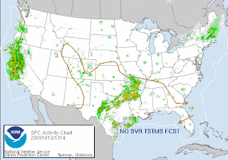 Another dose of flooding rain is rolling in tomorrow, which will put much of north Georgia under water. Now, that area of storms over on the west coast... guess what that is... It's the system formerly known as Super Typhoon Melor. That's right, the remnants of Melor have tracked all the way across the Pacific Ocean and have decided to pummel the west coast of the US with flooding rain. That area is preparing for mudslides. As if they didn't have their share of natural disaster with all the wild fires they endured over the summer.
We've had dreary skies and rain/drizzle in my neck of the woods, which seems to be taking its toll on people, that and the sticky humidity... I think we are ready for some colorful fall-like weather!
Have a superb day!!
~Dewdrop
Monday, October 12, 2009
Cooking up a storm, literally...
Well, with no weather brewing in my neck of the woods, my wonderful groom and I opted to cook up a storm in the kitchen. It was really a wonderfully relaxing weekend. We had so much fun together, but it all started with our own rendition of "Chopped". If you don't happen to watch that show, it's similar to many of the elimination reality shows out there today, except on this one, there are only 4 contestants. They are given mystery ingredients (usually off the wall and unrelated) and asked to prepare an appetizer.  The chef of the least liked appetizer is eliminated and the remaining chefs prepare an entree and a dessert through the same pattern, until a single winner remains and is awarded $10,000. Nice, huh? Well, for us, that show is appointment TV. When we see the ingredients, I will often ask my wonderful groom what he would make. I don't know what it is about the show, but we love it. Well, on Friday, I picked up a few ingredient choices of my own, and he was challenged with preparing our 3 courses from those.
So, what was on the secret ingredient list???
Appetizer: Puff Pastry, Avocado, Artichoke Hearts and Ginger Root. I would describe his avocado-artichoke pâté w/ balsamic braised ginger puff pastry towers as... scrumdiddlyuptious! Even the presentation was pretty cool. He was so cute whipping up stuff in the kitchen. Where I thrive around weather, he thrives in the kitchen. I love all the passion he has for creating in the kitchen, especially since I am not a huge fan of cooking.
After we devoured that yumminess, I presented the next round of mystery ingredients, which were still a secret to him.  Entree Ingredients: Skinless Chicken Breast, Turmeric (which stains the counter horribly, but it's nothing bleach can't handle), Chanterelle Mushrooms, and Banana Chips. :D He knocked it out of the ball park!! Yummy! You see those banana chips rehydrating...? Drowning their sorrows more like... He added apple jelly to make a wonderfully flavored jelly to eat with the chicken.
  In the end, he had created drunken chanterelle chicken rolls with tipsy banana puree'. Yes, we were getting a little silly after this round. The chanterelles had bathed in a pool of whiskey, while the banana chips rehydrated with some vodka. The flavors though... yummy, yummy.
 Then, the final round was dessert, where I brought out Pomegranate, Ricotta Cheese, Pepperidge Farm Milanoes, and a Milky Way. Seriously, how can you go wrong melting heavy cream and milky way together??? My theory on life, "You can never go wrong with a Milky Way." So the Milky Way melt was just a covering for the yummy Kahlua Milano brownie. The bits of Milano added bursts of explosive yum throughout the dessert:
Milano Way brownie and pomegranate cream... for mature tastes... It may not have been the most appetizing looking dessert, but oh my!!! Ta da!
Of course, I mentioned cooking up a storm, I somehow missed capturing the tornado that blasted through our kitchen...  He sure is excellent chef, but he can also wreak havoc in a kitchen.
 I know you're not here to hear about our kitchen escapades, so let me share this... Tropical Storm Parma (remember that one? The storm that has killed 600 or so, so far in the Philippines) has made its 3rd landfall, this time in China. It is devastating the impact that Parma (the storm that wouldn't end) has had on that region. Fortunately, Parma should be downgraded before making landfall again.
 In addition to that, back in the states, while the higher elevations are battling snow storms and ice on the roads, here in the south where we are battling humid and warm weather, the Atlanta area is being pummeled once again with gobs of rain, causing flash flooding and reigniting the fears of those who have just endured serious flooding in that region. After years of drought... they are now dealing with a scary surplus that is literally washing them away. Unfortunately, what they are experiencing today is nothing compared to what's in the forecast. Turn Around, Don't Drown.™
Apparently, the storm brewing at our house, brewed up a little something-something. 3:00PM radar.
AREAS AFFECTED...PARTS OF S CNTRL GA INTO EXTREME SRN SOUTH CAROLINA
Have a great day!
CONCERNING...SEVERE POTENTIAL...WATCH UNLIKELY
SEVERAL LOW AMPLITUDE MID-LEVEL WAVES ARE APPARENT WITHIN THE WEST SOUTHWESTERLY FLOW ON THE NORTHERN FRINGE OF SUBTROPICAL RIDGING CENTERED OVER THE FLORIDA PENINSULA. PERHAPS THE MOST SIGNIFICANT OF THESE MAY BE CURRENTLY ACCELERATING EASTWARD THROUGH THE CAROLINAS. IN ITS WAKE...A SURFACE COLD FRONT HAS BEEN ADVANCING SOUTHWARD THROUGH SOUTH CENTRAL GEORGIA AND SOUTHERN SOUTH CAROLINA...UNDERCUTTING DISCRETE CONVECTIVE CELLS FORMING IN THE WARM AND VERY MOIST TO ITS SOUTH...AND AHEAD OF THE NEXT MID-LEVEL WAVE. WHILE THE PRE-FRONTAL BOUNDARY LAYER AIR MASS IS CHARACTERIZED BY WEAK TO MODERATE POTENTIAL INSTABILITY... LOW-LEVEL FLOW FIELDS IN THIS ENVIRONMENT HAVE BEEN SLOWLY WEAKENING...CONFINING STRONG LOW-LEVEL SHEAR TO AREAS IMMEDIATELY ALONG AND TO THE NORTH OF THE FRONT. GIVEN THE STABILITY OF THE POST-FRONTAL BOUNDARY LAYER...ANY RISK FOR TORNADOES SEEMS CONFINED
TO THE IMMEDIATE VICINITY OF THE FRONT...AND LIKELY SHORT-LIVED...WITH THE POSSIBLE LOW PROBABILITY EXCEPTION OF ANY CELL ABLE TO PROPAGATE ALONG IT FOR A SUSTAINED TIME PERIOD. OTHERWISE...LOCALIZED STRONG WIND GUSTS AND PERHAPS SOME HAIL SEEM
TO THE BE PRIMARY SEVERE THREATS SOUTH/EAST OF MACON INTO THE SAVANNAH AREA THROUGH 22-23Z.
~Dewdrop


