 SKY WATCH FRIDAY time! Welcome all sky fans!!! I truly appreciate your visit and comments. I might not have time to respond to you, but I will try my best to visit!!!
Our hosts: Klaus Sandy Sylvia Wren Louise Fishing Guy
Thanks, also,to Dot and Tom, who were instrumental in the success of this blogging event. You should definitely come fly with us! HAPPY NEW YEAR!!
Ahh, another year is about to pass us by. What a year it's been!! Blizzards and floods and fires, oh my. Many records were set this year regarding rainfall and flooding. Then, some records were set for early snowfall and cold temps. Tropically and tornadically, we were generally below the average, but I wouldn't try to tell that to the person who lost their child off the coast of Maine to Hurricane Bill, nor would I tell it to the little south Georgia community of Thomasville, who lost their homes to the tornado that ravaged their area in February. Here's how the year compares though. Granted, the average was slightly skewed by the overactive years of 2008 and 2004. As for hurricane season, it came and went without much fanfare (unless you look at the far east where typhoons tore apart much of the Philippines and surrounding areas), but the Atlantic Basin hurricane season was the least active one since 1997 (source).
![]()
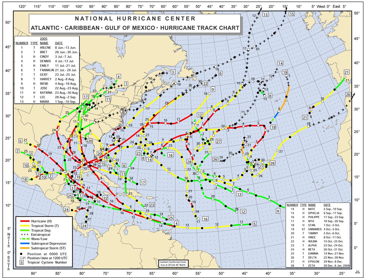 I've seen maps (such as 2005) where you couldn't even easily distinguish which track went where, but this year's map of activity is rather easy to make out. Incidentally, this is the one from the 2005 season, where we went well into the Greek alphabet with naming, which is a rare thing. We had named storms into JANUARY that year! That year actually set the record for the most named storms.
Many blessings for a safe and prosperous New Year!
~Dewdrop
Thursday, December 31, 2009
HAPPY NEW YEAR
Tuesday, December 29, 2009
It's COLD!
A cold air mass has inundated the whole country and there is apparently more to come as the week passes by. A snow storm in Texas (jeepers, they've had lots of snow storms this year!) will work its way across to the east bringing another round of snow to the northeast and COLD to the southeast. Ick! Here is a look at what we are expecting tonight. The forecast for this morning had called for temperatures to dip down to 26°. Thank goodness, they were wrong on that one. My last look before leaving was 32°, and the sun was up. It's possible that it crept down a few more degrees, but unlikely that it dropped that much after sunrise. Fortunately, they are only expected it to drop to 34° tonight... still horrendous, but I don't plan on spending any time out in it. Dewdrops don't do well in freezings temps.
Stay warm,
~D-d-d-dewdrop
Monday, December 28, 2009
Ho, ho, hi!!
 Merry Christmas to everyone. I hope your Christmas was blessed, and that it was a nice enjoyable break, full of rest and fun. I know it was for us. Except for my wonderful groom leaving to pick up his dear children, we were home relaxing all day long.
  We had a terrific time opening (way toooooooo many!!!!) presents, and then, it was time to play with (and eat) all the new goodies. We are truly blessed to have so much love surrounding us. Don't miss the before and after shots... insanity at its best.
One gift, in particular, was a gift that Mini-Dew gave to her dear step-brother; it was a big hit with everyone, a 7' inflatable, water-launched rocket, which soared about 100' into the air. Even the neighbors enjoyed this one. I mean, look at it!! My wonderful groom stands over 6', and my dear son is 5'11". It towers over them...  ...and then, with just a pint of water and some pressure....
 KA-BLEWY!! To the moon!!! In this case, it was divinely timed. When I looked up to shoot a picture of the gigantic rocket soaring through the air, I noticed a sky phenomenon, a special love note from God... a Circumzenithal arc, truly a rare treat! It was short-lived after noticing it, but perfectly timed for an intercept.
 So, it's back to the grind for me now... belly full of... CHOCOLATE, and I am ready to work. Glad it's a short week!
 Good tidings...
~Dewdrop
Monday, December 21, 2009
Objects in mirror ARE closer than they appear!
Friday for the south was buckets and buckets of rain. Fortunately, we escaped the brunt of it, but upstream and downstream was inundated with inches upon inches of rain. There was talk of some possible severe cells embedded within the system producing the gusher. The most exciting this that I experienced was driving under a significant flanking line. While I was under it, it looked like this... ... all rough, rugged and ominous under its underbelly... When I got away from it though, I was blown away by the magnificence of the swelling towers stealing against the brilliant blue sky.
  Note: Objects in mirror ARE closer than they appear.
The weekend was a chaotic one full of Christmas programs, activities and baked goods. While we were out visiting the house that my dear son is in the process of buying, Santa came by on his big red "sleigh" delivering goody bags to all the good little boys and girls. It was quite a treat... only in Ray City. Honestly, I love that they take the time and do this for all the little boys and girls.
This morning, after what seemed like a typically dreadful start to yet another manic Monday, I was blessed with this brilliant 22° solar halo. What a special Christmas treat! I took a moment to praise God and thank Him for reminding me to smile because He loves me. In case I don't get back around to my blog before then, I would like to wish everyone a blessed Christmas, from my home to yours.
2:45PM driving back from Christmas party, full solar halo.
God bless.
~Dewdrop
Thursday, December 17, 2009
Feeling wet, wet, wet
SKY WATCH FRIDAY time! Welcome all sky fans!!! I truly appreciate your visit and comments. I might not have time to respond to you, but I will try my best to visit!!!
Our hosts: Klaus Sandy Sylvia Wren Louise Fishing Guy
Thanks, also,to Dot and Tom, who were instrumental in the success of this blogging event. You should definitely come fly with us!
I have a funny story for you today. As a storm chaser, any movie with weather fascinates me, either as I pick it apart, pointing out the errors resulting from the production company's limited weather knowledge, or as I appreciate the awesomeness, power and fury of nature. Last night, when I finished taking care of getting Mini-Dew to finish her make-up work from missing a day of school and off to bed, I went into our room to find my wonderful groom watching (of all things) "Twister". Stop me in my tracks! I love that movie(!)... but, of couse. So, I plopped down in front of the TV and started watching along with him. It was a scene where Helen Hunt (Jo) and Bill Paxton (Bill) were examining the sky before a tornado developed talking about cloud heights... and something I hadn't noticed before until last night was that the clouds in that scene were my most absolute favorite clouds ever! MAMMATUS CLOUDS! Granted, it was just a flash of them on the screen, and they weren't the most magnificent display, but... HOW HAVE I MISSED THAT BEFORE?! I have seen the movie about 40,000 times (sadly not too terribly far from exaggeration). How did I miss my favorite clouds?! Anyways, in case you have no clue what I am talking about when I say mammatus clouds. I had a wonderfully powerful display a year ago. 
Mammatus (also known as mammatocumulus, meaning "bumpy clouds") is a meteorological term applied to a cellular pattern of pouches hanging underneath the base of a cloud. The name "mammatus" is derived from the Latin mamma (breast), due to the resemblance between the shape of these clouds and human female breasts.As for everything else, the Gulf Coast has been experiencing the wettest December on record, thanks, in large part, to el niño. Unfortunately, that spells flooding and lots of it widespread. Check out this gusher.
~source

 This area of low pressure off the Gulf of Mexico is a source of way too much precipitation in Texas and Louisiana, but rain bands are expected to stretch out as far as Georgia during the course of the day. Flood watches, flash flood watches and flood warnings have been plastered across much of the southeast. If you encounter water over a road, Turn Around, Don't Drown™!! Do not try to drive in flood waters.
Have a blessed (and dry) day!
~Dewdrop
Wednesday, December 16, 2009
Cool clouds and fall's arrival!
Up and down, up and down... that's how our temperatures have been lately. If you don't like the weather, just wait a minute. I shouldn't complain. The weather here today is generally mild, a little cooler than I like, but at least it's not frigid with horrendous wind.  At least with the cooler weather comes fascinating skies. This morning's sky was a blanket of striking altocumulus, slightly obscuring the rising sun. Since that time, the sun has been buried under a layer of stratocumulus clouds. At least the altocumulus clouds were pretty. Now, it's just grey and dreary. One thing that is fairly interesting is that our leaves changed color over the weekend. Yes, yes, I realize that the remainder of the country has long since peaked out and shed leaves, but we are just now getting our ocean of golds, reds and oranges. Autumn has finally arrived in south Georgia.
 Have a blessed day!!
~Dewdrop
Monday, December 14, 2009
Tornado warnings in Alabama and Georgia

 Damage, trees down, and people trapped in a home in Americus, Georgia with a line of storms currently barreling through southeast Alabama and southwest Georgia. People in the path of this dangerous storm system should be ready to get into a safe spot. It is tornadic and has produced damage. Turn on your weather radios (if they aren't already on, and take any warnings seriously.

TORNADOES~Dew
2220 7 SW ARITON, COFFEE COUNTY, AL
TRAINED SPOTTER REPORTED A TORNADO SOUTHWEST OF ARITON, AL ALONG COUNTY ROAD 51.
2225 ROCKY HEAD, DALE COUNTY, AL
EMERGENCY MANAGER REPORTED DAMAGE IN ROCKY HEAD WITH DOWNED TREES.
WIND REPORTS
2245 UNK SPEED AMERICUS, SUMTER COUNTY, GA
TREE DOWN ON A HOUSE ON OGLETHORPE STREET WITH PEOPLE TRAPPED INSIDE. SEVERAL REPORTS OF FUNNEL CLOUDS.
Fog so thick, you can slice it with a knife
The big weather news story today is the blanket of fog that was (and still is) draped across the nation from Washington D.C., all the way to Texas, down into Florida, cutting visibility in some parts to as low as 1/10th of a mile. So, what causes fog?
Well, fog is basically clouds on the ground. It is formed in the same way that clouds in the sky are formed.  Moisture in the atmosphere condenses when the temperature and the dewpoint temperature collide, generating a close to, if not 100% relative humidity. In this case, radiation fog is what we see across the country. The surface was warmed throughout the day. Then, as the cooler air quickly moved in with the night and high pressure, fog formed.
Fog cuts visibility causing travel nightmares. You want to make certain and use low beams when facing fog, as high beams, reflect off the fog and actually hurt visibility. Also, it causes delays at airports for the sake of traffic management. Exercise extra caution during periods of dense fog.
Dense Fog Advisory
The warning from the National Weather Service, which has issued dense fog advisories for many areas is that during periods of dense fog, meaning fog in some areas cuts visibility to less than 1/4 of a mile, is that you should:
A DENSE FOG ADVISORY MEANS VISIBILITIES WILL FREQUENTLY BE REDUCED TO LESS THAN ONE QUARTER MILE. IF DRIVING...SLOW DOWN...USE YOUR HEADLIGHTS...AND LEAVE PLENTY OF DISTANCE AHEAD OF YOU.For details about your area, click on your region after following this map to the link.
 The dark grey areas denote areas with dense fog advisories issued by the National Weather Service.
Have a great day!
~Dewdrop
Thursday, December 10, 2009
Tornado confirmed in Gardi, Georgia
SKY WATCH FRIDAY time! Welcome all sky fans!!! I truly appreciate your visit and comments. I might not have time to respond to you, but I will try my best to visit!!!
Our hosts: Klaus Sandy Sylvia Wren Louise Fishing Guy
Thanks, also,to Dot and Tom, who were instrumental in the success of this blogging event. You should definitely come fly with us!

 Yesterday brought some thunderstorm yumminess to our region, as the low pressure system containing blizzard-like conditions on its northern end produced severe weather down in the south. We didn't have any beautiful structure, such as what is pictured above, and it certainly wasn't the set-up that should be chased. The rain was coming down in buckets, which makes visibility a challenge. One storm cell that passed through my actual city was showing signs of rotation prior to arrival. In fact, it was actually tornado warned for a little while as it tracked northward. All that green, yellow and especially red, indicates rain... the red is especially heavy. When it's raining like that, seeing rotation in the clouds becomes especially difficult, if not impossible. We were actually experiencing the tail of that low pressure, in the form of a squall line of storm activity. It sort of whips around a wall of wind and rain, which can have some hail and tornadoes in the mix.
  There are some storm reports from yesterdays weather, mostly in the form of wind reports; however, there is talk of the damage actually being caused by a possible tornado. There is actually now a report of one confirmed EF0 tornado with an injury, which occurred in Gardi, GA.
5 MILES NW GARDI in WAYNE COUNTY, GA... which piggy-backs off this report of wind damage in the same city.
*** 1 INJ *** A NWS STORM SURVEY CONFIRMED AN EF0 TOUCHDOWN AT 632 LONGFORD ROAD. ONE MOBILE HOME WAS DESTROYED, AND THE INHABITANT WAS INJURED. SEVERAL BARNS WERE DAMA (JAX)
4 MILES NNW GARDI in WAYNE COUNTY, GAThere was a similar report out of Tallahassee, but no tornado has been confirmed yet.
*** 1 INJ *** POSSIBLE TORNADO. ONE TRAILER DAMAGED AND ONE TRAILER COMPLETELY DESTROYED. ONE PERSON INJURED BUT AMBULATORY. EMPTY SCHOOL BUS TOSSED INTO A DITCH. (JAX)
7 MILES NW OF TALLAHASSEE IN LEON COUNTY, FLIt was a rough day for some, while others were snowed in...
POSSIBLE TORNADO. HOMES DAMAGED...TREES DOWN IN VICINITY OF BRILL ROAD AND MILLERS LANDING ROAD ON NORTH SIDE OF LAKE JACKSON. (TAE)
Have a safe day!
~Dewdrop
Wednesday, December 09, 2009
Tornado warning headed my way

LINGERING THREAT FOR MARGINAL SEVERE STORMS OR EVEN AN ISOLATED TORNADO MAY PERSIST THROUGH THE AFTERNOON ACROSS THE DISCUSSION AREA. WW -- WHILE NOT IMMINENT -- COULD BECOME NECESSARY AHEAD OF ONGOING/BROKEN CONVECTIVE LINE.

 It's headed this way. Not showing rotation though. Looks like hail.
Tornado watch close to home
 When they said this system would likely "squall out", they meant it! The tail of this monstrous blizzard forming low spans from Massachusetts into the Gulf of Mexico. It's a thin shred of a line, but embedded within it are ferocious winds, heavy rain, lightning, and a potential for tornadoes. Currently, there is a wild couple of tornado watch boxes covering portions of the southeastern US,specifically, Georgia and South Carolina.
 The one closest to my proximity is an oddly shaped watch box, which stops just to my north. We did have some clearing this morning, where I actually saw the moon, and the temps started out in the 70's. That gives the much needed heated to offer up the instability. The squall breaks apart just to our west, but I think potential might exist for isolated supercells ahead of the line. People located within the general vicinity of the red boxes need to be mindful of rapidly changing conditions and be ready to get into a safe spot, should the need arise.
Have a safe day!
~Dewdrop
Tuesday, December 08, 2009
From blizzards to tornadoes
 Well, there is major snow storm in the midwest... severe weather in the south as a low pressure system makes its way across the country. The snowfall in some areas is reaching record daily snowfall totals.
 Advisory about Dangerous Winter Storm
The Upper Mississippi River Valley Region will be impacted by a dangerous winter storm today through Wednesday. Significant snow, blowing and drifting of the snow, and the potential for white-out conditions all appear likely for this period. Winter storm or blizzard warnings are in effect for much of the region this afternoon through Wednesday evening.Now, on the southern end of this crazy winter storm, there is potential for severe weather. A threat for tornadoes exists in the south for today.
The storm will strengthen over Oklahoma today, moving northeast to the southern tip of Lake Michigan by Wednesday morning. Snow has already spread into northeast Iowa, southwest and central Wisconsin this morning, and will continue to spread northward through the day today. Snow will continue to fall across the region through most of Wednesday, gradually diminishing Wednesday evening as the storm system moves off to the northeast. Accumulations across the region will be in excess of 6 inches. Amounts of 12 inches or greater are possible across portions of eastern Iowa into southern Wisconsin.
In addition to the snow, the winds will become strong and gusty later tonight, increasing into the 20 to 30 mph range...with gusts as high as 40 mph. This will lead to blowing and drifting of the falling and fallen snow. Poor visibilities will result, with white-out conditions possible. In the open and unsheltered areas of southeast Minnesota and northeast Iowa, where the winds will be strongest, blizzard or near blizzard conditions could develop overnight tonight through the day on Wednesday.
This early season winter storm will cause significant impacts on travel, especially during the morning commute on Wednesday. Be prepared for school closings and event cancellations on Wednesday. Roads will become very treacherous, possibly impassable at times. Stay abreast of the latest information on this developing winter storm via the links below.
Winter Monitor
Winter Storm/Blizzard Warning
Hazardous Weather Outlook
Expected local snowfall totals for the event
Graphic Weather Story
Winter Storm Safety and Preparedness Information
EXPECT INCREASE IN TSTMS...SOME ROTATING... THROUGH THE AFTERNOON ALONG THE LOWER MS RIVER VALLEY WITH DIURNAL HEATING.
 Regardless of your location, looks like you have some sort of extreme weather happening or about to happen. Exercise extreme caution if you head out into any of it.
Have a great safe day!
~Dewdrop
Monday, December 07, 2009
Adventures in exploration
 We had a whirlwind weekend (about the only way my wind whirls in my life is just by the shear force my schedule generates...) I was a weather consultant for an event downtown that they almost cancelled because it was raining, until I said... "No, no, the rain is done.
  Sun is coming out. The show must go on." She trusted me, and lo and behold... sun! Whew. After that frantic preparations for the Christmas parade, which of course, had to coincide with THE COLDEST NIGHT OF THE SEASON! Fortunately, we were early in the line-up, so the warmth from the setting sun was still with us. We didn't completely freeze our tooties off. The long-johns helped. Woke up to 35° in my neck of the woods. YUCK! Dew turns into frost when we start getting those temps... yuck. With much of the country being inundated with snow, it's hard for me to complain too much about our chilly temps, but for south Georgia, it did get awfully cold over the weekend.
  My wonderful groom and I did have a wonderful time on an impromptu exploration adventure.
  Of course, I have some pics from that. We found a lovely trail along a creek (river?) complete with a fascinating stone church in construction. It was so charming. Actually, yesterday was a great sky day.
 The day started with an amazing fiery sunrise, perfectly textured.
 During our outdoor adventure, we saw a solar halo, and then the evening presented a sunset which rivaled the morning's sunrise.
 One thing my wonderful groom pointed out to me was the level of water rise during those September floods in Atlanta. You can see the pile of creek/river debris way up in the tree, well above the normal surface level.
Have a beautiful day!
~Dewdrop


