Yesterday's near sunset was amazing. What a powerful display it was! I was struck by the dynamic colors and the sensational crepuscular rays that reached up to heaven! Spectacular!  I love the special little love letters God sends me.
~Dew
Friday, May 28, 2010
Sensational Skies!
Thursday, May 27, 2010
Sky watch...

Thanks to Klaus for allowing me to share my post with everyone. Unfortunately, I am still impeded from visiting everyone by the annoying pursuits of the IT Nazis.
I want to share a picture of what our moon looked like last night. Picture this... a speckled cirrocumulus/altocumulus strewn sky, that resembles a scattering of cotton balls across the sky... Imagine, poking though that, a brilliant golden, nearly full moon, around it layers of a multi-colored corona radiating with a brilliant, reddish amber color. I didn't grab a picture because we were saying goodbye to my dear son and grabbing the kids to catch a glance, but I've seen it before. It was better last night, though...
Have a beautiful day!
~Dewdrop
Wednesday, May 26, 2010
Sensational skies


OK, so no, I haven't seen any real storm action in 10,000 forevers, but I have had some great clouds, and I'll take that. We are actually getting into a more summer-like pattern of afternoon and evening, scattered showers and thunderstorms.
On Saturday, though, my wonderful groom and I had a fantastic light show, coming back from a friends house. There was a nice cloud-to-cloud show going on, but given how late it was, we just hit the sack rather than chase it down. The above shots are some sample skies from the past few days.
Have a great day!
~Dewdrop
P.S. Alex didn't ever happen... nothing in the hopper either. So much for a pre-season appetizer.
Monday, May 24, 2010
First blip of the year in the tropics

Well, it looks like we have a decent shot at the first named storm earning its name before the official start of the 2010 Atlantic Basin Hurricane Season, which starts June 1. There is a significant wave in the Atlantic that they have given a 30% chance of developing into a tropical or subtropical cyclone during the next couple of days. If this system rates a name, it will be called Alex.
Aside from that, the plains are still very much alive with severe weather with tornado reports every day for the past 6 days. One wedge over the weekend in South Dakota was on the ground for 24 minutes. Crazy.
Have a beautiful day!
~Dewdrop
Thursday, May 20, 2010
Sky Watch Friday brought to you by Dewdrop

Unfortunately, the IT Nazis still have their noose held tightly around my neck. I am still held prisoner in my cement block office, and I still cannot visit blogs, sign up for Sky Watch Friday or even update my own blog in conventional ways without a tremendous amount of hassle and grief, so I am going to just share a sky shot today that makes me happy for this beloved Sky Watch Friday event.
Yep, the crawler shot with the magnificent purple sky definitely brings a smile to my face. Hopefully it will do the same for you!
Hope your day is grande.
~Dewdrop
Wednesday, May 19, 2010

Tornado warnings in Oklahoma

Two cells in OK have already been tornado warned. They were the first two to develop this afternoon.

Resources and information for people in the OKC area


Dangerous Storms expected in Oklahoma today!
What You Can Do To Be Prepared
It is important to review safety information before the threat of severe weather materializes. Have a plan and know how to react.
- Severe Weather Safety Checklist
- Tips on Receiving Severe Weather Warnings
- Tips on Developing a Severe Weather Safety Plan
- Monitor the latest weather forecasts
- Know where you will be Monday afternoon and evening, and be prepared to react to warnings in those situations.
- If you have a severe weather safety plan, now is the time to review that.
- Learn more about "the cap" and the concept of instability by watching this briefing.
Elevated to a high risk over central Oklahoma
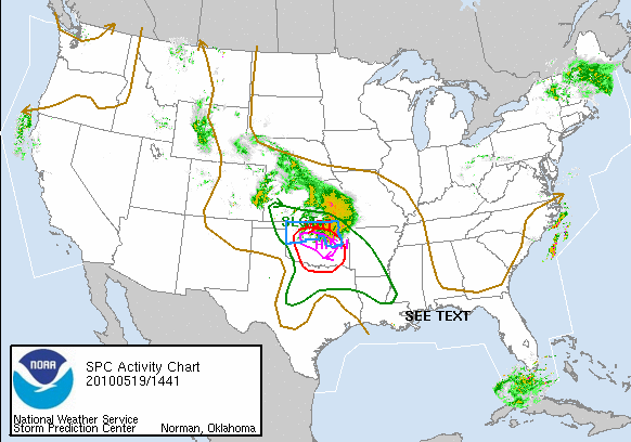

The SPC has elevated the risk for Central to a High Risk, now warning that there is a 30% chance of EF2 or greater tornadoes within 25 miles of the points included in the outlined area.
NWS STORM PREDICTION CENTER IN NORMAN OK IS FORECASTING THE DEVELOPMENT OF A FEW STRONG TORNADOES OVER PARTS OF OKLAHOMA LATER THIS AFTERNOON AND EARLY TONIGHT. SUPERCELLS WILL BE LIKELY WITH TORNADOES...VERY LARGE HAIL AND DAMAGING WIND GUSTS. A FEW OF THE TORNADOES MAY BE STRONG
I would expect a PDS(Particularly Dangerous Situation) Tornado Watch soon. The very hard part of this is that the target is over a highly populated metropolitan area. If tornadoes form, they are more likely to have an impact on lives and property.
~Dew
It's like De'ja vous


Watching TWC this morning, and hearing the banter leading up to today, I see that Oklahoma (the same area pummeled with a massive tornado outbreak a week and a half ago) is facing a moderate risk for today. There is a 90% chance according to TWC's Tor:Con index. According to SPC, there is only a 15% chance today that an EF2 or greater tornado will occur in their hatched area.
A Public Severe Weather Outlook has been issued and conditions are favorable for a significant outbreak again today and tonight.
NWS STORM PREDICTION CENTER IN NORMAN OK IS FORECASTING THE DEVELOPMENT OF TORNADOES...LARGE HAIL AND DAMAGING WINDS OVER PRIMARILY OKLAHOMA THIS AFTERNOON AND TONIGHT.
THE AREAS MOST LIKELY TO EXPERIENCE THIS ACTIVITY INCLUDE
PARTS OF WESTERN ARKANSAS
MUCH OF OKLAHOMA
SMALL PART OF NORTHERN TEXASSTORM DEVELOPMENT IS EXPECTED TO INCREASE ACROSS NORTHERN AND WESTERN OKLAHOMA BY MID AFTERNOON AND QUICKLY BECOME SEVERE. CONDITIONS WILL BE FAVORABLE FOR LARGE SUPERCELL THUNDERSTORMS WHICH WILL INCLUDE A THREAT OF NOT ONLY TORNADOES BUT VERY LARGE HAIL AND DAMAGING WINDS.
We have seen reports of softball sized hail in parts of these areas with recent storms. I can't even imagine an updraft required to generate hail the size of softballs. That is amazing. I mean think about the weight of a 4.5" diameter chunk of ice. Imagine air strong enough to lift that up into a cloud to refreeze a layer of rain on it. Hard to imagine...
People in the highlighted areas should be mindful of the weather, especially in light of the fact that these storms will likely turn severe quickly. Be ready to get into your safe spot.
I read a note from my sis, quoting her daughter while they were watching TWC. She said, "Yay, they are making my Saturday beautiful for me..."
Have a beautiful day!
~Dewdrop
Monday, May 17, 2010
Big skies
I got a call from my wonderful groom about a magnificent cell to our south. He was driving home from work, and I was inside cooking dinner, so I ran outside with my camera in hand... he wondered what radar on it would be.  As it turns out, it was the top of a cell that was about 30 miles away, and I was looking at it just in time for show time. That's right, sunset.
Oh, and this one boomed for me on Sunday! :D Have a great night!
~Dewdrop

Sunday, May 16, 2010

Saturday, May 15, 2010

Thursday, May 13, 2010
The Promise

Unfortunately, the IT Nazis are prevailing. Not only am I not able to update my blog the conventional way, I am not able to list my blog on
... which is a definite source of frustration and dissappointment in my life, but Klaus (one of the hard working members of the Sky Watch team) has graciously agreed to link my blog when he posts his link. Unfortunately, I am not able to visit any blogs anymore, which sort of breaks my heart because it's a wonderful escape to be able to see skies around the world each week. It gets me out of my concrete block prison cell for just a few moments and know that God has placed this beauty around the world to encourage and uplift us. I will not be discouraged. I know that God is still there making beautiful skies. Our God is just that awesome.
Have a brilliant day!
~Dewdrop
Tuesday, May 11, 2010
The 2010 Oklahoma Outbreak


Sometimes, I get the feeling like I know too much about the weather. I watch the radar, and I see signatures on the radar that suggest immediately to me that devastation is imminent, and it breaks my heart in two. I hate to see a powerful supercell racing toward a city, and area I know is populated, knowing that people's lives are about to be changed forever or stolen by a vicious beast of a storm. I am saddened to the core. I see it clearly; I see that a cell has strong rotation, is likely on the ground, all indications point to a powerful tornado, and a city lies in wait as it races toward it... Five lives were stolen in yesterday's tornado outbreak, which was referred to by the Storm Prediction Center as a high risk, with a Particularly Dangerous Situation (PDS) tornado watch issued ahead of the storms. They saw, and I am sure they cringed... their hearts broke much like mine, knowing that this would mean bad things, devastating things to these people in the path of what was to come.
As a storm chaser, I know what weather has in store. I know it's phenomenal power and the devastation it can cause. I know the horrific destruction it can leave in its wake. Sure, I think that nature is amazing, awesome even, but the destruction is... surreal, heart-breaking. I am glad that the guys I was assisting with Nowcasting made it safely home (they were on storm track #6 as it literally breezed by them, most likely as a tornado-- the 2nd graphic shows some storm tracks during yesterday's outbreak). There were a total of 37 tornado reports, as depicted in the 1st graphic. Unfortunately, storms line up for the same area over today and tomorrow.
My thoughts and prayers are with all those impacted during yesterday's outbreak.
Peace that surpasses all understanding,
~Dewdrop
Monday, May 10, 2010

In position
 They are in position on I40, just east of the rotation. Exact location, just east of the intersection of 165 and I40, just east of Warner, OK, at Charlie's Fried Chicken, with the nicest people ever.
The chase is on.


 Mike and JB are south of Wagoner, AL, hoping for an intercept with a tornado that is currently showing powerful rotation on radar. They are racing south to try to get into a safe position south of the rotation. I am praying hard for their safety.
Incidentally, they are the red dot, slightly to the east of all this mess. 25 28 34 tornado reports already today.
~Dew
Holy cow...

Watching this tornado coverage on the news now. It was a huge wedge with multiple vortices. They were all winding with one another. This is the Wakita tornado.


Mike and JB after a newborn cell

A tornado warned cell in Wakita, OK seems to be producing significant rotation and some sizable hail. Reports that it has damaged buildings are coming through. Mike and JB are the red dot mark near Orlando, OK, and they are headed north for an intercept of the newly severe warned cell. Mike and I suspect tornado warning soon on it.
Did I call that or what?!
TORNADO WATCH FOR PORTIONS OF
SOUTH CENTRAL KANSAS
CENTRAL AND WESTERN OKLAHOMA
EFFECTIVE THIS MONDAY AFTERNOON AND EVENING FROM 125 PM UNTIL 1000 PM CDT.
...THIS IS A PARTICULARLY DANGEROUS SITUATION...
DESTRUCTIVE TORNADOES...LARGE HAIL TO 4 INCHES IN DIAMETER... THUNDERSTORM WIND GUSTS TO 80 MPH...AND DANGEROUS LIGHTNING ARE POSSIBLE IN THESE AREAS.
More Mammatus!!!


What a special blessing it was to step outside Saturday evening to be greeted with a sky covered in mammatus, bold and well defined mammatus, hazy mammatus looking more like orbs, and billowing rows of mammatus. The sky was covered in them, and I was in heaven. I was literally hanging out the window taking pics of the sky while my wonderful groom drove. The hazy ones in the last shot are exactly as they appeared.
Down the road, we pulled over to grab them with sunset, but they faded as the sun dropped beneath the horizon. I view it as a wonderful early Mothers' Day gift from God. It encouraged me and uplifted me... especially after not being able to chase the severe and tornado warned cells that were very nearby.
As an aside, while we were pulled over, the property owner/developer stopped to offer to sell us a lot in the neighborhood he will be destroying my view with... He obviously didn't know who he was talking to...
~Dew
Alabama storm chasers have their sites set on Oklahoma


When the moderate risk popped up for eastern Oklahoma, JB contacted Alabama Mike (both members of the Southern Weather Brigade) about the chasetunity it presented and asked if he would like to join him on a trip to Oklahoma today. They watched the models throughout the weekend, and decided ultimately last night that they would pursue a moderate risk or greater, but they would go ahead and leave at the butt-crack of dawn to get on the road and be in position once the intsbility got there, with plans to turn around if it was (doubtfully) downgraded. When I heard from Alabama Mike this morning, they were 112 miles from Oklahoma, had been driving through the rain all morning through Arkansas and were very excited to see that they were chasing a high risk system. The chance today for an intercept is terrific, as a tornado outbreak is expected.
THE MOST FAVORABLE PHASING OF THE UNSTABLE WARM SECTOR AND STRONG VERTICAL SHEAR ENVIRONMENT WILL OCCUR LATE THIS AFTERNOON/EVENING ACROSS CENTRAL/N CENTRAL/NE OK. EFFECTIVE SRH OF 400-600 M2/S2...BOUNDARY LAYER DEWPOINTS OF 65-70 F AND MLCAPE OF 2000-3500 J/KG ALL FAVOR THE POTENTIAL FOR STRONG/LONG-TRACK TORNADOES IN THE MDT-HIGH RISK AREAS.
POTENTIAL CONCERNS WILL BE THE LATE ARRIVAL AND NARROW WIDTH OF THE WARM SECTOR COMPARED TO THE STRONG VERTICAL SHEAR PROFILES AND FAST STORM MOTIONS. A COMPARISON OF EXPECTED 45-50 KT STORM MOTIONS WITH WARM SECTOR WIDTH/PROGRESSION SUGGESTS A 2-3 HOUR WINDOW FOR SUPERCELLS TO MATURE. IT APPEARS THIS WINDOW OF OPPORTUNITY WILL BE SUFFICIENTLY LONG TO SUPPORT A SIGNIFICANT SUPERCELL/TORNADO RISK FOR A FEW HOURS LATE THIS AFTERNOON/ EVENING...INCLUDING THE WICHITA...TULSA...AND OKLAHOMA CITY METROPOLITAN AREAS.
A Public Severe Weather Outlook has been issued for the area by the National Weather Service. I would expect a PDS during that window given the fact that metropolitan areas are in the bullseye.
Be safe, all you chasers. Live to chase another day!
~Dewdrop
Saturday, May 08, 2010

Friday, May 07, 2010
Severe Weather in Ohio
A severe weather. possible tornado outbreak is possible in the Ohio River Valley today. The area of the greatest risk is expected to be in Ohio and Indiana, where a Public Severe Weather Outlook has been issued by the Storm Prediction Center.

Unfortunately, this area is not as comfortable as the plains or the south in dealing with severe weather events, so if tornadoes are spawned in this storm, it could be devastating. If you are located anywhere within the area of risk, particularly in the area of moderate risk, be mindful of rapidly changing conditions and have a plan already prepared for seeking shelter, should that need arise. Keep your weather radios close.
Have a beautiful weekend and Mothers' Day!
~Dewdrop
Thursday, May 06, 2010
Kansas has a shot
 SKY WATCH FRIDAY time! Thanks to Dot and Tom, never forgotten founders of this great event. Come on, come fly with us!
Thanks to hosts: Klaus Sandy Sylvia Wren Louise Fishing Guy My days (actually minutes) of being able to head my Sky Watch posts this way are numbered, but I want to do it while I can. Dealing with IT Nazis can be challenging and frustrating. I just wish this blog wasn’t such a treasured escape from the blah of my cinder block prison. I know, I know, so atypical of me, posting a picture of a bird, not something weather related, but in order to post a weather-related picture, I would need weather (you can check out my archive special storm shot posted below if you like… it’s more along the lines of what you usually see from me.) This is a special hawk though. He landed on a tree, just on the other side of my cinder block prison, ignoring the taunts of the bold (stupid) mockingbirds that swooped in to terrorize him for apparently treading on their territory. I can understand wanting to protect your babies, but eek, who’s going to feed those babies when the irritated hawk bites your head off??? Anyways, a co-worker was out there and saw it land and came running in, beckoning me to come quick and bring my camera (she must know me…) So, there you have it, dewdropweather is posting a bird.
Speaking of weather though… (what? You didn’t think I would stay off weather all together, did you?), there is a slight risk smack dab in the middle of the plains today, which has Vortex 2 chomping at the bit for some action. Unfortunately for them, it doesn’t look like tornadoes are a big part of the severe forecast for the day, so they may end up just chasing hail, but at least they’ll have something.
The tornado hatched area is only about 2% likely to have tornadoes, but I would imagine that Vortex 2 is camped out in northwestern Kansas with their fingers crossed.
Be safe!
~Dewdrop
Wednesday, May 05, 2010
Test of the emergency blogpost system

I am testing the system of posting to blogger using email. We'll see how this works in the effort to maintain my blog-munications.
~Dew
Looks like it'll work just fine. I just won't have much control over where my pics are in the post. Sigh.
The IT Nazis!
In the world of IT-Nazis , I have been blocked… access to my blog limited to mere 10 minute quota. I am disgusted. I am saddened. This blog is my window to the world. It’s where I peak out and say, “Hey, y’all! This is what’s going on here. What you got going on???” Unfortunately, that portal has been obstructed, and I am allowed only a small window to look out and connect with my dear blog world of friends. That’s ok. I will survive, and no matter what, I will still bring you the weather.
So, the only tornado report yesterday was in Wisconsin.
Tornado Reports (CSV) (Raw Tornado CSV)A storm chaser was on it, and actually got some footage of it, so I know it was actually a tornado. It’s insane to me that the storms are already firing up that far north. The plains season has been sad this year. It’s really not been a great season for storm chasers. Unfortunately, the storms that have occurred have hit largely populated areas, so the deaths related to the fewer storms is much higher than I would have expected.
Time Location County State Lat Lon Comments
0012 4 W WINCHESTER WINNEBAGO WI 4420 8874 (GRB)
...NUMBER OF TORNADOES... NUMBER OF KILLERGiven the fact that so far this year, we have seen only approximately 50% of the tornadoes we saw last year at the same point, the fact that we have already seen 12 tornado deaths through April, versus the 15 at the same point in 2009. Granted, 2 of the very few tornadoes we have had so far were rated EF4.
TORNADO DEATHS TORNADOES
..2010.. 2009 2008 2007 3YR 3YR 3YR
PREL ACT ACT ACT ACT AV 10 09 08 07 AV 10 09 08 07 AV
JAN 41 28 6 84 21 37 0 0 7 2 3 0 0 4 1 2
FEB 1 1 36 147 52 78 0 9 59 22 30 0 2 12 3 6
MAR 36 - 115 129 170 138 1 0 4 27 10 1 0 3 10 4
APR 197 - 226 189 167 194 11 6 0 9 5 2 3 0 3 2

 Vortex 2, the Great Tornado Hunt, as it’s been dubbed by TWC is off and… standing still… They seem to repel weather the way I do. I hate it for them. They have a lot of resources and time wrapped up in this month long tornado chasing project, and they haven’t had a bite yet. Fortunately, it looks like the forecast is warming up further south for some action next week. The SPC has outlined an area of potential severe action in the better chased areas of the southern plains. Hopefully, that’ll give the project what they are after and keep all the action away from these populated areas, which would protect lives.
Have a beautiful IT Nazi-free day!
~Dewdrop
Subscribe to:
Posts (Atom)


