 Sky Watch Friday post time!!! Yes, yes, I know it's early... for one, I have a full day meeting tomorrow that will prevent me from getting my post out, and this way, maybe I won't be number 190 on the sky watch list. Now, I need to find inspiration quickly, as Thursdays are busy...(Please visit our host, Tom's blog to participate in Sky Watch Fridays. So much fun!!! I highly recommend it!) Today, I am posting a picture of Altocumulus Clouds (Specifically an Altocumulus mackerel sky)...
Altocumulus mackerel sky
The photograph was taken in January of this year... seeing this type of sky always reminds me of snow days from the days when I lived up north. Anytime I see it, I think of cold weather, which is a welcome relief, as we have been coping with 90 plus degree temps lately... eww. (I know, I know... I complain when it's too cold, I complain when it's too hot. Told you I am geographically misplaced. I should live a more migratory lifestyle.)
Genus Alto- (mediumhigh) -cumulus (heaped)
A mackerel sky is an indicator of moisture (the cloud) and instability (the cumulus form) at intermediate levels (2400-6100 m, 8000-20,000 ft). If the lower atmosphere is stable and no moist air moves in, the weather will most likely remain dry. However, moisture at lower levels combined with surface temperature instability can lead to rainshowers or thunderstorms should the rising moist air reach this layer. In the winter it is often said to precede snowstorms and flurries. There is an old saying, "Mackerel sky, mackerel sky. Never long wet and never long dry." The phrase 'mackerel sky' came from the fact that it looks similar to the markings of an adult king mackerel.

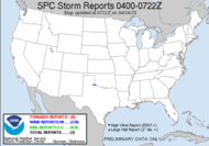
SYNOPTIC PATTERN IS ONE OF EARLY SPRING KINEMATICS WITH LATE SPRING THERMODYNAMICS. A SIGNIFICANT SVR WEATHER OUTBREAK IN TERMS OF BOTH COVERAGE AND INTENSITY APPEARS LIKELY...ESPECIALLY OVER THE MDT RISK REGION...WHERE BOTH TORNADOES AND WIDESPREAD DMGG WINDS APPEAR LIKELY. GIVEN QUALITY OF MOISTURE INFLOW AND MERIDIONAL EXTENT OF WARM SECTOR...THESE COULD YIELD STRONG...LONG TRACK TORNADOES.
Strong wording, huh? Of course, a Public Severe Weather Outlook has been issued. THE NWS STORM PREDICTION CENTER IN NORMAN OK IS FORECASTING WIDESPREAD DAMAGING THUNDERSTORM WINDS...STRONG TORNADOES AND LARGE HAIL OVER A LARGE PART OF THE EASTERN PLAINS AND THE UPPER MISSISSIPPI VALLEY THIS AFTERNOON THROUGH TONIGHT.
A worse consideration is that this same area is the target area for a moderate risk for severe weather tomorrow, and a slight risk for severe weather on Saturday. Conditions are ripe. My heart sunk when I saw the outlook for today. The folks in these areas, this very large area need to be vigilant about watching the weather and heeding EVERY warning issued.
THE AREAS MOST LIKELY TO EXPERIENCE THIS ACTIVITY INCLUDE
MUCH OF IOWA
CENTRAL AND EASTERN KANSAS
SOUTHERN AND CENTRAL MINNESOTA
WESTERN AND NORTHERN MISSOURI
CENTRAL AND EASTERN NEBRASKA
WESTERN...CENTRAL AND NORTHERN OKLAHOMA
EASTERN SOUTH DAKOTA
WESTERN AND CENTRAL WISCONSIN
1800EDT Update: THE NWS STORM PREDICTION CENTER HAS ISSUED A TORNADO WATCH FOR PORTIONS OF
God bless,
PARTS OF EASTERN KANSAS
PARTS OF WESTERN MISSOURI
EFFECTIVE THIS THURSDAY AFTERNOON FROM 455 PM UNTIL MIDNIGHT CDT.
...THIS IS A PARTICULARLY DANGEROUS SITUATION...
DESTRUCTIVE TORNADOES...LARGE HAIL TO 3 INCHES IN DIAMETER... THUNDERSTORM WIND GUSTS TO 90 MPH...AND DANGEROUS LIGHTNING ARE POSSIBLE IN THESE AREAS.
THE TORNADO WATCH AREA IS APPROXIMATELY ALONG AND 65 STATUTE MILES EAST AND WEST OF A LINE FROM 55 MILES SOUTHWEST OF CHANUTE KANSAS TO 50 MILES NORTHEAST OF FALLS CITY NEBRASKA.
~Dewdrop
Thursday, June 05, 2008
Mackerel sky, mackerel sky. Never long wet and never long dry.
Labels:
High Risk,
sky watch Friday,
Tornado Outbreak 2008
Subscribe to:
Post Comments (Atom)


wonderful clouds. great catch
ReplyDeleteToday will break all the records!
ReplyDeleteSCM
Thanks, Tommy.
ReplyDeleteMikey, I agree with you! It could be a really awful day.
We have had tornado warnings here the past few days. Glad it is over. I like your photos. This is quite beautiful.
ReplyDeleteLike a field of cotton clouds!
ReplyDeleteDew: Holy Mackrel, what a sky for SWF. Very nice with the music.
ReplyDeleteI see cotton, too! But so very far away! Beautiful sky.
ReplyDeleteWhat an amazing year, I keep wishing i could be out there. One day, one day. Have a great weekend, my dewriffic friend!!
ReplyDeleteLike cotton... that clowds.
ReplyDeleteAnd I learnd some thinng in this post too. Thank you.
What a fabulous photo. I'd call them popcorn clouds. I must be hungry. Have a great weekend!
ReplyDeleteHoly Mackerel. You learned me something today.
ReplyDeleteAbraham, Where are you located? May not be over... Thanks...
ReplyDeleteQuint, I like that... cotton.
Fishing guy, LOL!!! Glad you likes it.
Sandy, Cotton fields are plentiful here in south Georgia.
Jess, We'll get out there again. Have a terrific weekend, Meso Momma!!!
Anemone, Glad you learned something. Thanks.
Musings, Good luck with the move. Popcorn clouds... cool. I like it.
Texican, Glad I was able to teach you something... :O)
Weather is fascinating, and the clouds on your picture is great!
ReplyDeleteThose cumulus clouds are really something! A sight worth photographing! Happy skzwatching!
ReplyDeleteThanks for the post and service!
ReplyDeleteMrs. Darcy, I am definitely captivated by weather, as if my blog doesn't give that away.
ReplyDeleteMirage, I couldn't agree more!!!! Ditto to you!
For the people, Wow, gladly. You're very welcome.
ReplyDeleteGreat sky watch :)
ReplyDeleteGreat photo.
ReplyDeleteGreat information.
Great music.
Life is good.
Thanks for visiting my wet sky,
Troy
PS: I try to visit often, but don't comment too much. Just know that you are a favorite and I like everything that you do Dew.
Marie, THANKS!
ReplyDeleteTroy, Wow, thanks!!! I really appreciate that! Life IS good! :O)
Very cool!! Love this post!
ReplyDeleteWell done Dew, one of my favourite skies this.. great post.... again.
ReplyDeleteChamp, Thanks. Love it?! Wow. Thanks.
ReplyDeleteTom, You are so kind.
Simply wonderful, his photo. Congratulations.
ReplyDeleteAnother excellent post.
ReplyDeleteDoes your name translate to "Voice of my Heart"? How beautiful... Thanks. I love sky shots.
ReplyDeleteDaniel, Same to you. I just want to run away to the places you capture. Thank you.
I don't think I have ever been so lucky as to capture clouds like this...I really like this photo.
ReplyDeleteRose, Just keep looking to the sky. It will happen for you. Amazing stuff up there. Thanks!
ReplyDeletewow i really love those clouds great catch!
ReplyDeleteMagnificent demonstration of the sky
ReplyDeleteLyn, Thanks a BUNCH!!!
ReplyDeleteLuz, I thought so too. Thanks!
Gosh, I'm seeing spots. I guess I'm not supposed to adjust my monitor or anything silly like that, hey? That's a great shot.... those skies actually make me sick to my stomach when walking in a large field... seriously. Yeh, I'm a wuss... LOL.
ReplyDeleteI still get car sick believe it or not...
Great post. =)
Rocky Mountain Retreat
Lol, Michele. You make me laugh. I actually still get car sick... it's not a good thing. I also get sea sick and I get sick on spinny rides. THANKS!!!
ReplyDeleteGreat shot. :)
ReplyDeleteThe best thing is everything i learn from your posts.
Thanks for sharing.
It`s interesting!
You would be bored here at my place. I haven`t seen a drop of rain in six weeks.... ;)))
Thanks, Ida. Glad you're enjoying learning about weather stuff from my blog and that you find it interesting. Wonderful!!! All I've had is about a drop in six weeks... it's frustrating.
ReplyDeletelike a cotton field
ReplyDeleteI can't wait to get a picture of a cotton field with an altocumulus mackerel sky over it.
ReplyDeleteYou make me giggle sometimes, I love how you explain everything. I can't possibly leave without complimenting you on the skywatch photo!
ReplyDeleteHope you have an exciting skywatch weekend!
Cotton Candy in the sky!
ReplyDeleteAlways a "treat" here!
Wonderful clouds!
ReplyDeleteLately in southern Arizona we've not seen many clouds at all.
ReplyDeleteNow I know why...........
thanks
Very interesting post - and "Louis" likes the 'cotton ball cloud' sky, or mackerel sky, if you prefer.
ReplyDeleteTo fog or not to fog: that is the question.
Great information, though I'd have identified these as altocumulous perlucidus. Perhaps Mackerel is just another name? Very nice, in any case.
ReplyDeleteSounds like a scary but exciting year, weatherwise. Thanks for the lesson.
ReplyDeleteLove the mackerel sky... and all the great information you post along with your photos! Most instructive!
ReplyDeleteSandy, Glad I make you giggle, and I am so glad you commented. I am glad you enjoy my posts. I will definitely keep my eyes to the sky. Saw another sea breeze thunderhead like last night... tonight... pretty obscured by trees along my route, but magnificent, nonetheless.
ReplyDeleteCarletta, You're so kind to me... glad you enjoyed the "treat".
Sandpiper, Yes, very cool, I think, too.
Gusto! Gotta have moisture. I can't imagine how dry it must get out there... it's gotta be better than the suffocating humidity here. I imagine they sell lots of moisturizer there though.
Glad "Louis" likes the sky shot. Cotton Candy. You guys are great!!!
Chuck, I am not familiar with that cloud type... and haven't been able to find anything on it... could you share a link? THANKS!
EG Tour, Very scary how this year is working out... the numbers will only continue to rise. You're very welcome.
Neal, Thanks. They were very cool. I remember taking that pic that morning. A neighbor drove by... no telling what they thought...
Pat, So glad you like the info!!! When are we chasing? ;O)
Oh Wow! Stay safe!
ReplyDeleteGreat cloud shots!!
Thanks, Lana g! I will!
ReplyDeleteWonderful clouds formation.
ReplyDeleteJohn, Isn't it complete coolness?!
ReplyDelete