Proud mommy moment... Mini-Dew woke up this morning and asked, "You know what I dreamed about last night?"
I was intrigued... "What?"
Mini-Dew: "I dreamed that I was in Atlanta, and I saw 8 1/2 tornadoes."
Me: "8 1/2?"
Mini-Dew: "I could only see part of the other one."
Me: "Oh, so it was more like a funnel cloud?"
Mini-Dew: "No, I could see the top, and I could see the bottom, but the middle, I couldn't see." (9 tornadoes!!!! What a dream!!!)
Me: "So, was this a good dream or a scary dream?"
Mini-Dew: "Oh, it was cool!"
My little budding storm chaser... dreaming about tornadoes. How cool is that?!  Speaking of tornadoes, several folks in Louisiana early were awakened this morning by the sound of their weather radios (I sure hope!) blaring warnings of tornadoes, as the tail of the snow storm up by the Lakes has been generating some rotating storms with large hail and strong winds on the southside, with Louisiana, Arkansas and Mississippi falling within an are of moderate risk for severe weather today and into tonight in Mississippi. A public severe weather outlook has been issued by the Storm Prediction Center (SPC).
 BASED ON GREATER INSTABILITY THAN EARLIER EXPECTED A SMALL AREA OF LA AND MS HAS BEEN UPGRADED TO A MDT RISK. VERY STRONG SHEAR PROFILES EXPECTED TO REMAIN IN PLACE MUCH OF LOWER MS VALLEY THRU THE DAY...SUPPORTIVE OF ORGANIZED THUNDERSTORMS INCLUDING POTENTIAL TORNADIC SUPERCELLS.
Despite tornado warnings this morning, the only reports so far are for large hail that occurred in Texas. Should be an interesting day.
WITH DAYTIME HEATING AND CONTINUED INCREASING GULF MOISTURE...SEVERE THUNDERSTORMS EXPECTED TO INCREASE IN NUMBER AND INTENSITY. SUPERCELLS INCLUDING THE POSSIBILITY OF STRONG TORNADOES ARE POSSIBLE GIVEN THE STRENGTH OF THE WINDS FIELDS ALONG WITH THE EXPECTED INSTABILITY.
11:00AM tornado warning headed toward Alexandria, LA...
Update 1:27PM1727 ALEXANDRIA, RAPIDES PARRISH, LA
Still going too...
TWO TORNADOES ON THE GROUND. REPORTED BY RED CROSS.
1645 ALEXANDRIA, RAPIDES PARRISH, LA
ACME REFRIGERATOR ON EMPRIRE DRIVE HAD A CINDER BLOCK WALL ALMOST COMPLETELY BLOWN OUT. REPORTED BY KALB TV5 IN ALEXANDRIA.  Try to have a lovely day!
Dewdrop
Tuesday, December 09, 2008
Dreaming of tornadoes


Thursday, June 05, 2008
Mackerel sky, mackerel sky. Never long wet and never long dry.
 Sky Watch Friday post time!!! Yes, yes, I know it's early... for one, I have a full day meeting tomorrow that will prevent me from getting my post out, and this way, maybe I won't be number 190 on the sky watch list. Now, I need to find inspiration quickly, as Thursdays are busy...(Please visit our host, Tom's blog to participate in Sky Watch Fridays. So much fun!!! I highly recommend it!) Today, I am posting a picture of Altocumulus Clouds (Specifically an Altocumulus mackerel sky)...
Altocumulus mackerel sky
The photograph was taken in January of this year... seeing this type of sky always reminds me of snow days from the days when I lived up north. Anytime I see it, I think of cold weather, which is a welcome relief, as we have been coping with 90 plus degree temps lately... eww. (I know, I know... I complain when it's too cold, I complain when it's too hot. Told you I am geographically misplaced. I should live a more migratory lifestyle.)
Genus Alto- (mediumhigh) -cumulus (heaped)
A mackerel sky is an indicator of moisture (the cloud) and instability (the cumulus form) at intermediate levels (2400-6100 m, 8000-20,000 ft). If the lower atmosphere is stable and no moist air moves in, the weather will most likely remain dry. However, moisture at lower levels combined with surface temperature instability can lead to rainshowers or thunderstorms should the rising moist air reach this layer. In the winter it is often said to precede snowstorms and flurries. There is an old saying, "Mackerel sky, mackerel sky. Never long wet and never long dry." The phrase 'mackerel sky' came from the fact that it looks similar to the markings of an adult king mackerel.

SYNOPTIC PATTERN IS ONE OF EARLY SPRING KINEMATICS WITH LATE SPRING THERMODYNAMICS. A SIGNIFICANT SVR WEATHER OUTBREAK IN TERMS OF BOTH COVERAGE AND INTENSITY APPEARS LIKELY...ESPECIALLY OVER THE MDT RISK REGION...WHERE BOTH TORNADOES AND WIDESPREAD DMGG WINDS APPEAR LIKELY. GIVEN QUALITY OF MOISTURE INFLOW AND MERIDIONAL EXTENT OF WARM SECTOR...THESE COULD YIELD STRONG...LONG TRACK TORNADOES.
Strong wording, huh? Of course, a Public Severe Weather Outlook has been issued. THE NWS STORM PREDICTION CENTER IN NORMAN OK IS FORECASTING WIDESPREAD DAMAGING THUNDERSTORM WINDS...STRONG TORNADOES AND LARGE HAIL OVER A LARGE PART OF THE EASTERN PLAINS AND THE UPPER MISSISSIPPI VALLEY THIS AFTERNOON THROUGH TONIGHT.
A worse consideration is that this same area is the target area for a moderate risk for severe weather tomorrow, and a slight risk for severe weather on Saturday. Conditions are ripe. My heart sunk when I saw the outlook for today. The folks in these areas, this very large area need to be vigilant about watching the weather and heeding EVERY warning issued.
THE AREAS MOST LIKELY TO EXPERIENCE THIS ACTIVITY INCLUDE
MUCH OF IOWA
CENTRAL AND EASTERN KANSAS
SOUTHERN AND CENTRAL MINNESOTA
WESTERN AND NORTHERN MISSOURI
CENTRAL AND EASTERN NEBRASKA
WESTERN...CENTRAL AND NORTHERN OKLAHOMA
EASTERN SOUTH DAKOTA
WESTERN AND CENTRAL WISCONSIN
1800EDT Update: THE NWS STORM PREDICTION CENTER HAS ISSUED A TORNADO WATCH FOR PORTIONS OF
God bless,
PARTS OF EASTERN KANSAS
PARTS OF WESTERN MISSOURI
EFFECTIVE THIS THURSDAY AFTERNOON FROM 455 PM UNTIL MIDNIGHT CDT.
...THIS IS A PARTICULARLY DANGEROUS SITUATION...
DESTRUCTIVE TORNADOES...LARGE HAIL TO 3 INCHES IN DIAMETER... THUNDERSTORM WIND GUSTS TO 90 MPH...AND DANGEROUS LIGHTNING ARE POSSIBLE IN THESE AREAS.
THE TORNADO WATCH AREA IS APPROXIMATELY ALONG AND 65 STATUTE MILES EAST AND WEST OF A LINE FROM 55 MILES SOUTHWEST OF CHANUTE KANSAS TO 50 MILES NORTHEAST OF FALLS CITY NEBRASKA.
~Dewdrop
Thursday, May 22, 2008
Colorado tornado outbreak currently underway!!


 Boulder County... Fort Collins, CO... Milliken, CO... tornadoes being reported... Windsor (SE of Fort Collins) has reported SEVERE damage and baseball sized hail... Wellington, CO... Folks, this is bad.
 EXTREMELY LARGE TORNADO in Milliken... wow. There is one fatality reported, but that is not confirmed. Some fatalities (more than one) reported by the Weld County sheriff. He is sharing an emotional discussion of his encounter with the complete demolition of the Windsor area on this live stream (thanks, Paul). Schools on lock down... trouble responding because street signs are gone... another tornado warning up... God, be with these people...
Mikey (thanks, Mikey) sent me a link to this story... and it had a link to this... as part of a video stream of the Milliken tornado which appears to have been a LARGE WEDGE TORNADO...  Greeley, CO... here is the report...
 DIRECT HIT ON STATE FARM BUILDING. CARS TOSSED OFF OF ROAD. TREES DOWN. SWIFT COMPANY ROOF TORN OFF. TORNADO 3/4 TO 1 MILE WIDE
Better video capture of that wedge. Thanks, Mikey... for the link.
Unfortunately, it seems that it is Kansas and Nebraska's turn... a Particularly Dangerous Situation Tornado watch has been issued for the area outlined. 1636EDT: My heart just sunk as I read the updated outlook for today issued by the Storm Prediction Center, with Kansas being placed in a HIGH RISK for severe weather. People need to be ready for extremely dangerous weather.
  I am still watching the live stream out of Denver. It's tough to watch and listen to people's reactions and just know how devastating it was.
1706EDT Update: More incoming. Tornado in Gove... 1712EDT

GOVE, KS REPORT RELAYED FROM SPOTTER NETWORK
1733EDT: Looks like another tornado warning for around the Windsor area... Denver/Boulder radar went down as I was going after a capture. Here we go... Nunn, CO under fire... 1818EDT Update: I just noticed that Steve Miller TX is en route to a cell that I expect will be tornado warned momentarily. I guess he didn't have to work so much after all... it lured him away... I can understand. Go Steve, go!!!
 1900EDT Update: Steve Miller, TX is making headway and it has held together and been tornado warned...
 2209EDT Update: 36 tornado reports...so far...
 ~Dew
~Dew
Monday, May 12, 2008
Nesting... and the races... and other severe stuff...
 Another Monday, another "Odd Shots Monday" shot. This time, my shot would most likely fall under the rare part of odd... not really just odd. This bird's nest is located in bf's car port. We actually watched as the mommy and daddy birds worked feverishly to build the nest, and then, bf actually noted the eggs in there and wanted me to photograph that. Well, by the time we finally made it there for the shot, I saw feathers in the picture. I had to hold the camera over my head, so we climbed to get closer. About 4 baby birds filled that little nest. Bf made mommy bird sounds to get the birds to crane their necks... teasing those poor little babies. It was SO sweet though!!!
 In order to participate in "Odd Shots", visit Katney's blog. I will post about the very active and deadly weather weekend shortly. (Sadly, I was able to keep that sentence from last week's post... what a horrific year of destructive weather...)
First let me share a little of my weekend with you... as I mentioned, bf and I were headed to the drag races. Turns out it was a pretty big drag racing event, a televised NDRL drag race... for what it's worth. It was a first for both of us, but we were actually both quite surprised how much we actually enjoyed it. It was amazing how fast these vehicle were going! 191.02mph in 3.947 seconds! Amazing. We did witness one wreck, as the driver lost control while manually shifting since he had no 3rd gear. He fish tailed a ways and then slammed into the wall. The driver was ok. All the race fans around us were picking on me for taking more pictures of the sky than the races. lol. Who me? Here are some of my favorite shots from the races.


 We had a great time, and if anyone reading ever has the opportunity, I HIGHLY recommend it.
As for the weather... this weekend was a ferocious weather weekend. Ma Nature went on a rampage all through the plains on Saturday and all over Georgia, North Carolina, South Carolina, Kentucky and Ohio on Sunday. For many, it turned out to be a nightmarish Mother's Day. I have heard that there were 22 deaths attributed to the tornadoes. In addition to that, the images of destruction being shown on TWC today presented an unimaginable glimpse into the horror that lies ahead for these folks. Buildings obliterated. Vehicles crushed. Homes and livelihoods destroyed. This year's tornadoes are historic. Saturday's storms included a horribly destructive and deadly EF-4 tornado in Missouri. Reports on the Missouri portion of the storm are located here. Unlike previous storms, I will not offer a list of all the storm reports... With 52 tornado reports on Saturday and 20 on Sunday, it would be much easier just to direct you over to the NWS main page. From there, you can select the area of the country that interests you the most and get the local survey results for those areas. The Springfield, MO NWS office did do a great synopsis of the storm on May 10, which is located here. For a summary of the storm reports, feel free to click on the two graphics below.
For Saturday: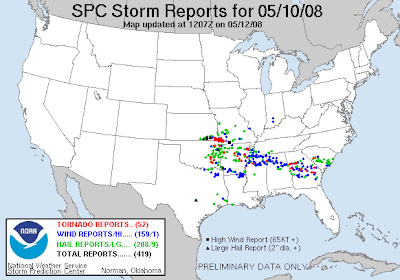

 Just to revisit the trend analysis graphic that just amazes me. This puts us almost at the total number of tornado reports from the ENTIRE year last year, and we are currently only 1/4 of the way through the peak tornado season! This year is definitely making history.
 Bf and I did go out and "storm chased" a little thunderhead that blazed on through the area... didn't catch anything (at all) except a little dust storm from the ferocious winds we were experiencing all day. We really didn't expect to catch anything, but having just been issued the second tornado watch of the day, we figured why not... we were headed out anyhow. The next local weather event is projected to arrive... THURSDAY and Friday. Sheesh.
 Have a blessed Monday,
~Dewdrop
Saturday, May 10, 2008
Rough Scene Today - Tornado outbreak...

 As I type, there are 4 tornado warnings in Arkansas, and there is one a few counties from here in Georgia. I hate nighttime events! God be with all those in these storms paths. God be with everyone tomorrow as the event continues into tomorrow. I am headed to bed after a very exciting night at the drag strip. There is a tornado watch in place 4 counties to my north. I'll have my weather radio on... just in case.
1. PICHER, OTTAWA COUNTY, OK *** 5 FATAL ***
God bless y'all,
EM REPORTS 20 BLOCKS OF STRUCTURES HEAVILY DAMAGED
2. SENECA, NEWTON COUNTY, MO *** 3 FATAL ***
TORNADO HAS STRUCK NUMEROUS RESIDENCES BETWEEN SENECA AND NEOSHO. THREE FATALATIES AND NUMEROUS INJURIES HAVE BEEN REPORTED AND HIGHWAY 60 IS CLOSED DUE
3. PURDY, BARRY COUNTY, MO *** 1 FATAL ***
DAMAGE TO 4 TRAILER HOMES...A CHURCH...HOMES...AND SEVERAL OUTBUILDINGS IN THE PURDY AREA. 1 FATALITY REPORTED BY EMERGENCY MANAGER.
4. CARTHAGE, JASPER COUNTY, MO *** 1 FATAL ***
TREE LANDED ON TRAILER HOUSE APPROXIMATELY 4 MILES EAST OF CARTHAGE SOUTH OF HIGHWAY 96 NEAR COUNTY ROAD 80. DAMAGE PATH FROM COUNTY ROAD 80 TO COUNTY R
5. RACINE, NEWTON COUNTY, MO *** 10 FATAL ***
TORNADO DAMAGED OR DESTROYED NUMEROUS BUILDINGS. PRELIMINARY REPORTS INDICATE 10 FATALITIES...EIGHT NORTHWEST OF RACINE AND TWO NORTH OF RACINE. NWS ST
~Dew
Friday, May 09, 2008
Solar halo and sun dogs and TORNADOES... oh my...
Sky Watch Friday post time!!! (Please visit Tom's blog to participate.) Today, I have chosen my solar halo shot to post. It is my first and only time witnessing a solar halo first hand. I had seen photographs of solar halos taken by others but had never personally caught one. I saw this one on the way to work one morning. 
A halo (also known as the 22° Halo, nimbus, icebow or Gloriole) is an optical phenomenon that appears near or around the Sun or Moon. There are many types of optical halos, but they are mostly caused by ice crystals in cold cirrus clouds located high (3–6 miles) in the upper troposphere. The particular shape and orientation of the crystals is responsible for the type of halo observed. Light is reflected and refracted by the ice crystals and may split up into colors because of dispersion, similarly to the rainbow. Source.
On this specific solar halo, there were sun dogs on either side. I see sun dogs all the time, and I love them! Here is a photograph of my favorite sun dog shot.
22º radius halos are visible all over the world and throughout the year. Look out for them whenever the sky is wisped or hazed with thin cirrus clouds. These clouds are cold and contain ice crystals in even the hottest climates. The halo is always the same diameter regardless of its position in the sky. Sometimes only parts of the complete circle are visible.
When looking for halos ALWAYS shield both eyes from the sun. Never stare close to it even for a moment. Preferably, hide the sun behind the edge of a building or post. Take care when photographing halos if the unshielded sun is in the field of view. It is dangerous to look at the sun through some camera viewfinders, especially SLRs - do not take risks! Source.
A sun dog or sundog (scientific name parhelion, plural parhelia, for "beside the sun") is a common bright circular spot on a solar halo. It is an atmospheric optical phenomenon primarily associated with the reflection or refraction of sunlight by small ice crystals making up cirrus or cirrostratus clouds. Often, two sun dogs can be seen (one on each side of the sun) simultaneously. Source.
Now, let me touch on this horrific situation in Myanmar, just to offer an update. I can't imagine... I just can't imagine. Those innocent people, victims of a militaristic regime, which places absolutely no value on human life. They must not realize that their actions will wipe out their population... after this, they won't have anyone left to torture or hold captive. The much needed aid that the UN sent over was confiscated by the junta, forcing the UN to stop the aid, and now there are a million or so folks in desperate need of safe food and water. Not to mention, they are living among rotting carcasses. Horrendous. Here is an article if you are interested.
Onto yesterday's severe weather outbreak. I am struck by the one two three... four punch being offered up for the southern states by Ma Nature. Check this out...
Thursday's Outlook: Friday's Outlook:
 Saturday's Outlook (now with a moderate risk for severe weather):
 ... and Sunday's Outlook (happy Mother's Day to me!!! A chasetunity!):
IF CONVECTIVE CONTAMINATION DOES NOT OCCUR FROM DAY2 ACTIVITY...A POTENTIALLY SIGNIFICANT SEVERE EVENT COULD OCCUR ACROSS THE OUTLOOK REGION AS PROFILES FAVOR VERY FAST MOVING SUPERCELL STRUCTURES. AN UPGRADE MAY BE REQUIRED IN LATER OUTLOOKS IF MODEL DATA CONTINUES TO SUPPORT THIS EVOLUTION.
With the limited visibility yesterday, which prevented Alabama Mike from seeing anything, he sure has been given a few do-overs. Btw, he posted a youtube video that he found of the Leighton, AL tornado that passed through a parking lot tossing cars around like pieces of scrap paper. Check it out.
Now, as for yesterday's weather, there were a total of 21 tornado reports, with one tornado in NC resulting in a fatality and some injuries. 
Some reports are available for yesterday's tornadoes:
1. Storm Survey Report for northeast MS (click here), done by the
Memphis, TN - NWS office
Photographs and Local Storm Reports yesterday
2. Storm survey report for north Alabama, done by the
Huntsville, AL - NWS office
3. Nashville, TN - NWS office (no report yet)
Local Storm Reports
4. Storm survey report for western Kansas done by the
Goodland, KS - NWS office
5. Wilmington, OH - NWS office (no report yet)
6. Raleigh, NC - NWS office (no report yet) (this is the area that had a fatality reported)
Stay tuned.
Toodles,
~Dewdrop
Wednesday, February 06, 2008
Deadly tornadoes in Arkansas, Tennessee, and Kentucky leave a wake of Destruction

 Today, a large part of the eastern CONUS (Continental US) has been placed under a slight risk for severe weather by the SPC (Storm Prediction Center). I must give kudos to the SPC; yesterday, they placed the area struck the hardest under a high risk for severe weather, and they were strikingly accurate in their forecast for this intensely dangerous weather event. Today's slight risk has already produced tornado reports in Alabama and several tornado warnings have been issued this morning in eastern Alabama and northwest Georgia. I heard from Rick that Alabama Mike had a tornado within miles of his home, and Rick was able to offer some data support for Mike. I have not spoken with Mike yet to get his first-hand account of the events that transpired this morning, but I am awaiting that update. The SPC has a discussion about the outlook for today...
 MODEST INSTABILITY /MLCAPES OF 500-1000 J PER KG/ AND FORCING ALONG COLD FRONT SHOULD MAINTAIN A LINE OR CLUSTERS OF STORMS THROUGH THE MUCH OF THE DAY. THE PRESENCE OF 50-60 KT OF DEEP LAYER SHEAR SHOULD SUPPORT A CONTINUED THREAT OF SUPERCELLS AND BOWING STRUCTURES WITHIN LARGER CONVECTIVE BAND. ISOLATED TORNADOES WILL BE POSSIBLE ALONG WITH THE POTENTIAL FOR ISOLATED DAMAGING WINDS. THE TORNADO THREAT APPEARS HIGHEST THIS MORNING INTO EARLY AFTERNOON.
The most intense part of the remaining storm appears to be targeting the area further north of here, where it is likely that the outlook will be upgraded to a moderate risk for severe weather as the day continues... and there appears to be some question regarding the storm's life... HOWEVER...IT REMAINS QUESTIONABLE WHETHER ONGOING...PRE-FRONTAL LINE OF STORMS WILL CONTINUE TRANSLATING EWD OR IF STORMS WILL DIMINISH ACROSS THE CENTRAL APPALACHIANS AND ALLOW COLD FRONT TO FOCUS DEVELOPMENT LATER TODAY AND EARLY THIS EVENING.
This bit that they are referencing is more commonly known as "the Dewvoid". As a storm chaser, I have had more storms dissolve prior to getting to me than I can even mention.  In all seriousness though, this is a messy, destructive and deadly system. I don't wish this storm anywhere near any populated areas, so if the Dewvoid will save lives, I am all for it.... granted, if it holds together and makes it to my neck of the woods, I am on it. ;O) This is a look at what lies ahead for my neck of the woods. Stay tuned...
For some excellent coverage of the events of this horrific tornado outbreak, check out these sites...
Steve Miller - out of Oklahoma
Tony Laubach - out of Colorado
Jeff Gammons - out of Florida
David Drummond - out of Texas
Mike Wilhelm - out of Alabama
Chris Collura - out of Florida but temporarily in Chicago (he was in it, but he hasn't updated yet)
Michael Detwiler - out of Tennessee
This in from a blog visitor... Megan said...
If anyone has information about Angue, please get in touch with me, so I can pass the word along to Megan.
My sister in law was working at the hospital at the time of the tornado. My brother and their kids were at home and are fine, but no one in my family has heard from my sister n law. Her name is Angula McDonald. If anyone has any information about the hospital or other areas of Mtn. View, please post them here and I will check back frequently. My brother tried to get to the hospital last night, but he couldn't get past the security to make sure that Angue was okay.Donna said...
Ditto, with Sue Parracino, so I can let Donna know. Y'all might check with emergency management in those areas.
Hi my breeder of my dog lives in Mountain View her name is Sue Parracino does anyone know if she is OK. Thank you Donna 1:30 PM Update: I will be leaving shortly for a Doctor's appointment... here is a current radar snapshot of what's coming my way, just a solid squall line event, no really isolated cells worthy of storm chasing at this point. The NWS (National Weather Service) in Tallahassee issued a Special Weather Statement for the counties to my west, as a cell over that way has pulsed and bowed slightly... but otherwise, still just watching and waiting.
7:10 update: Of course, the "Dewvoid" prevails. The system fell apart, and there wasn't even one strike of lightning for me to capture... got a few drops of rain, but that is all. It seriously fell apart...
I got this comment from an anonymous reader: anonymous said...
So, feel free to check that out, and thanks a bunch to the anonymous reader for the update about Mountain View.
My mom lives in MV and she finally called me an hour or so ago. The hospital was hit, but all people from there are safe. The Chevy dealership was hit and some homes, but mostly the tornado went through open fields. She said only one lady died in MV. I guess they know no one else is dead because they have checked all damaged places. However, the power system was also hit, for the whole town. So no one has power at all and probably for a few days.
I've tried to find more info online, but it's hard. I did find a couple pictures of damage on Highway 5 at Arkansas Matters site
or just go to their homepage and scroll to the "Sever Weather Photos" and you can see more.
God be with all those affected or about to be affected.
~Dewdrop





















